| Western Terminus: |
Downtown Crystal Falls at US-2/US-141 (cnr Superior Ave & Crystal Ave) |
| Eastern Terminus: |
US-2/US-41 between Bark River and Hyde west of Escanaba |
| Length: |
65.260 miles |
| Maps: |
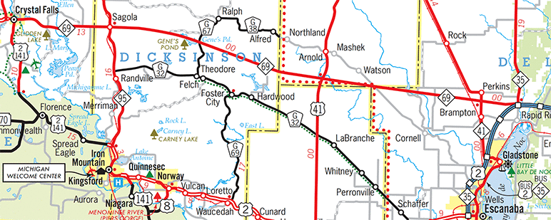
Route Map of M-69 |
| Notes: |
M-69 is a very rural, low-traffic-volume route in the central Upper Peninsula, serving as somewhat of an alternate route to US-2 between Crystal Falls on the west and west of Escanaba on the east. It is approximately six miles shorter and can be up to ten minutes less time to use M-69 between those two cities, especially since US-2 travels through the Iron Mountain–Quinnesec–Norway metropolitan area while the communities M-69 travels through are very small in comparison. Unfortunately, neither M-69 nor US-2 between Crystal Falls and Escanaba were included in the segments of highway increased to 65 mph in 2017, even though M-69 can be classified as rather desolate along most of its route and has few sharp turns nor any major vertical alignment changes. This being Michigan, one can assume average actual speeds along much of M-69 are likely to be greater than those along US-2, though. |
| |
In a case of ultimate irony, the easternmost 69% of M-69—the segment from M-95 near Randville in Dickinson Co to US-2/US-41 near Bark River in Delta Co—has been the subject of some jurisdictional contention over the years. This portion of the route was the last segment of the current route to be completed. The current iteration of M-69 (1927–present) was initially open to the hamlet of Hardwood in eastern Dickinson Co. for its first two years, but even after it was completed and open to traffic in 1929 all the way to US-2/US-41, it was a narrow (16-foot wide) low-volume, gravel roadway through relatively uninhabited territory. Then a decade later, State Highway Commissioner Murray D Van Wagoner unilaterally cancelled this eastern portion of the route without consulting the three counties it ran through, infuriating them in the process. Refusing to take M-69 back as a jurisdictionally-transferred route, the counties refused to maintain the roadway or clear it of snow in the winter. The standoff between the counties and the State Highway Dept lasted well over a year and was not resolved until the segment was "reinstated" as a trunkline in late 1940. However, twenty years later, the MSHD and the three counties apparently came to agreement and the same segment was officially abandoned as a trunkline and transferred to county control. (A dozen years later, the segment was designated as Intercounty route G-30.) Then, just over three decades after being abandoned, MDOT decided to re-establish this same eastern segment of M-69 as a state trunkline route once again! (In yet another "69"-related irony, this also created the interesting situation of M-69 intersecting G-69 at Foster City, which it still does.) The story, related to the webmaster, why this segment was re-established as a state highway was primarily due to political arrangements. For example, a downstate state legislator needed support for a bill or project so a U.P. legislator agreed to support it in exchange for, in this instance, additional state trunkline mileage. For a lightly-traveled highway in a sparsely-settled area, this route definitely has had a rather tumultuous history! |
| |
In "State Trunkline Needs, 1960–1980," a set of maps prepared by the State Highway Dept's Office of Planning, Programming Division in 1960 showing possible additions, upgrades and improvements to the state trunkline system over the ensuing twenty years, MSHD staff recommended one major change to M-69 during that timeframe:
- The turnback of the route of M-69 from M-95 in Dickinson Co easterly and southeasterly to US-2/US-41 in Delta Co is shown—and would come to fruition later that same year—but the MSHD planners had major ideas for the route east of M-95. Beginning at the M-95 & M-69 jct in Sagola, the proposed M-69 would continue due easterly for 5 miles before slowly bending southeasterly traveling through present-day Gene's Pond and passing just south of Norway Lake and continuing into Marquette Co running east-southeasterly to an intersection with a proposed new-route US-41 in Sec. 36 of T42N, R26W. The proposed M-69 would continue east-southeasterly just barely missing the northeastern corner of Menominee Co, crossing the Escanaba River at the Boney Falls Dam, intersecting M-35 (proposed to be redesignated as M-41) about a mile south of Perkins, finally terminating at a freeway interchange on the proposed US-2 freeway at the existing route of US-41 (proposed to be redesignated as a rerouted M-35) approximately 2 miles north of Rapid River. (See illustration below.)
|
 |
| History: |
1915 (Aug 27) – A 21-mile state trunkline highway route is officially designated in Iron Co consisting of two separate segments: From the Wisconsin state line on the Brule River 11 miles south of downtown Crystal Falls northerly for 10.0 miles via the communities of Stager and Mastodon to the southern city limit of Crystal Falls, and from the northern limit of Crystal Falls north-northwesterly for 11.0 miles to the community of Amasa. These two trunkline segments are assigned the designation of T.L. 69 (Trunk Line 69). |
| |
1919 (July 1) – T.L. 69 is signed in the field as M-69 as all state trunkline highways in Michigan are signed with route markers. The gaps in the officially established state trunkline route at the City of Crystal Falls consists of two locally-controlled roadway segments along with a state-controlled segment of T.L. 12 (now M-12) and is still signed as part of the route of M-69. The through-town route of M-69 consists of city-controlled 5th St northerly to Superior Ave, then northerly one additional block on 5th St and westerly 7 blocks along Crystal Ave (part of M-12 under state jurisdiction), then dirverting northerly along a locally-maintained roadway for 0.8 mile to the beginning of the 11-mile Crystal Falls–Amasa segment of state trunkline highway route. |
| |
1919 (Nov 18) – The 0.8 mile of 5th St in Crystal Falls from the southern city limit northerly to jct M-12 at the cnr of Superior Ave & 5th St is assumed into the state trunkline highway system as part of M-69. From Superior Ave & 5th St, M-69 continues as it had to this point. |
| |
1920 (June 21–July 28) – A total of 23.17 additional miles are added onto the northern end of M-69 when two trunkline establishments are made. On June 21, a 14.8-mile segment is established as a state trunkline route from the northern end of M-69 at Amasa northerly to the Iron/Baraga Co line. Five weeks later on July 28, an additional 8.37 mile segment of state trunkline is designated from the Iron/Baraga Co line northerly to a new terminus at M-28 at the present-day intersection of Murphy Rd & Haapa Rd approximately 1½ mile southeast of Covington. M-69 now officially travels from the Wisconsin state line south of Crystal Falls to M-28 southeast of Covington (with a 0.8-mile segment on the west side of Crystal Falls that has yet to be officially assumed into the trunkline system), however the portion from Amasa northerly toward Covington is not yet completed and opened to traffic and will likely not be until the end of 1921 or partway through 1922. |
| |
1921 (Jan 10) – The short approach roadway connecting M-45 (later M-95, now Bass Lake Rd) with the Upper Twin Falls Bridge over the Menominee River and Twin Falls Flowage along the Wisconsin state line north of Iron Mountain and the bridge itself are assumed into the state trunkline highway system. At approximately 0.1 mile, it is unclear if the bridge approach is posted in the field with any route designation. One source does show the M-69 designation applied to this short spur of highway on the Michigan side of the river, which would be logical as the highway on the Wisconsin side of the river is designated as STH-69 (State Trunk Highway 69), which leads back into Michigan south of Crystal Falls where the route continues as M-69. |
| |
1924 (Sept 24–26) – On Sept 24, the entire 19.0-mile length of M-28 from the Baraga/Houghton Co line easterly through Covington to M-15 (later US-41) at the hamlet of Tioga is cancelled as a state trunkline highway. Most of the westernmost 8 miles of the 19-mile route west of Covington is immediately re-established as a state trunkline route for M-28, with a few minor route changes, however, while the new route of M-28 from Covington easterly is routed to the north of Vermilac (Worm) Lake. Two days later on Sept 26, the 8.37 miles of M-69 in Baraga Co from the Iron Co line northerly to the former route of M-28 southeast of Covington is cancelled as a state trunkline route. Simultaneously, all but the northernmost ½ mile of the route of M-69 in Baraga Co is re-established as a state trunkline route along the same path. From ½ mile south of the former route of M-28, the route of M-69 is redirected to the northwest on a more direct alignment into Covington and a new northern terminus at the realigned M-28 there. |
| |
1926 – With the debut of the U.S. Highway system, the entire routing of M-69 is replaced by two of these new route designations. A few sources from 1926 show M-69 being replaced by a US-2/US-41 designation between the Wisconsin state line and Crystal Falls and by just US-41 from Crystal Falls to Covington. However, these 1926 maps were made from preliminary system maps and were often wrong, being corrected in 1927. When the U.S. Highway system is finalized, M-69 is to be replaced by a solo US-2 from Wisconsin into Crystal Falls and by US-102 (present-day US-141) from there to Covington. The M-69 designation is then to be transferred onto a route tanget to and perpendicular to its former one. The "new" M-69 will begin at US-2 in downtown Crystal Falls (it's present-day western terminus) and will proceed easterly replacing a portion of M-12 to M-45 (present-day M-95) at Sagola, then continue southerly via M-45 for approximately 7 miles, before turning easterly easterly again to supplant the M-90 designation through Metropolitan and Foster City in central Dickinson Co and terminating just east of the community of Hardwood, approximately 3 miles east of Foster City. |
| |
1927 (Feb 9) – The future M-69 is extended southeasterly when 27.0 miles of new state trunkline routing is officially assumed into the state highway system from the eastern terminus of existing M-90 just east of Hardwood in east-central Dickinson Co heading southeasterly parallel to the Chicago & North Western RR line through northern Menominee Co and into Delta Co, terminating at US-2/US-41 approximately 2 miles east of Bark River. Construction on the extension and several of the river crossings would not be complete until 1929 when it was fully opened to traffic. |
| |
1927 (May 2) – The new US Highway designations across the state of Michigan officially become effective today, with a small portion of US-2 and the entirety of US-102 superceeding the entire route of M-69 in Michigan, as noted above. Road crews erect temporary cardboard route markers over the existing state trunkline route markers for all new US Highways and changed state highways as a result of the new US Highways. While this marks the end of the first iteration of M-69 after just 12 years, the second (and current) iteration of M-69 immediately debuts along a portion of the former M-12 and all of the completed and open former M-90 between Crystal Falls and Hardwood (as also noted above). The State Highway Dept plans to have permanent markers in place by midsummer. |
| |
1929 (late?) – Four new timber bridges are completed at various river crossing along M-69 in northern Menominee Co between Hardwood and Perronville which marks the completion and opening to traffic of the segment of M-69 officially added to the trunkline system in February 1927. M-69 now exists (roughly) along its entire present-day routing at this time. For several decades later in the century, though, this would not be the case. |
| |
1931 (Aug 31) – A 7.9-mile realignment of M-69 in eastern Iron Co is officially assumed into the state trunkline system, beginning just east of Johanson Rd on the east side of Crystal Falls and continuing easterly along its present-day alignment to Colonys Corners where it merges back into the existing route. The new route shaves 0.9 mile off the overall route of M-69. The former 8.8-mile long route along Runkle Lake Rd (within the limits of Crystal Falls) and Old M-69 outside the city is simultaneously turned back to local control. |
| |
1937 (Aug 30) – Two realignments and abandonments in the route of M-69 on this date:
- A 7.9-mile realignment of M-69 in eastern Iron Co is officially assumed into the state trunkline system, beginning just east of Johanson Rd on the east side of Crystal Falls and continuing easterly along its present-day alignment to Colonys Corners where it merges back into the existing route. The former route along Runkle Lake Rd (within the limits of Crystal Falls) and Old M-69 outside the city is simultaneously turned back to local control.
- A new 3.79-mile segment of trunkline highway is officially established along the route of M-69/M-95 south of Sagola in west-central Dickinson Co. The 3.9-mile long former route, running generally alongside the Chicago, Milwaukee & St Paul RR line, is partly turned back to County control (a portion of today's Kramer Rd) and partly obliterated or abandoned as a public roadway (including a portion under the current Louisiana Pacific OSB manufacturing facility near Cary's Spur.
|
| |
1939 (July 26) – The State Highway Dept gives notice to the Dickinson, Menominee and Delta Co Road Commissions it is abandoning the 52.4 miles of M-69 in those counties between M-95 near Randville and US-2/US-41 east of Bark River and turning back the roadway to the respective counties. The department is looking to turn back any routes having a an average daily traffic count of 300 vehicles or less and this segment of M-69 has a traffic volume lower than that. Both Dickinson and Delta Cos immediately protests against the transfer with the State Transportation Commission stating "the transfers are not within the interest of the public welfare." County road officials are concerned that without the trunkline, the communities along this portion of M-69 will likely become abandoned themselves, as their livelihoods depend on highway access. The abandonment of M-69 east of M-95 is essentially held in limbo for well over a year while the situation is sorted out between the counties, State Highway Commissioner Murray D VanWagoner and involving the State Attorney General's office. |
| |
1940 (Sept 10) – While the portion of M-69 in Dickinson, Menominee and Delta Cos between M-95 near Randville and US-2/US-41 east of Bark River has technically not been a state trunkline highway route since mid-1939—according to the State Highway Dept—and never officially accepted back by the counties in a jurisdictional transfer, the MSHD essentially backs down to rectify the situation and approves that routes "reinstatement" as a trunkline route, approved by the State Administrative Board on this date. It refers to the reinstatement as "a bookkeeping" action, implying the cancellation on Juy 26 of the previous year was in error and this action is to fix that error. |
| |
1956 (Nov 15)–1957 (June 11) – The Groveland Mine in west-central Dickinson Co had started as an underground iron mine in the late 1800s, but during the 1940s and 1950s began converting over to an open air strip mining operation which needed the land through which M-69 ran. A new 8.5-mile realignment of M-69 was completed and opened to traffic around Nov 15, 1956. The realignment was officially assumed into the state trunkline system on June 11, 1957, the same day the 8.0-mile former route was cancelled as a state trunkline. The portions of the former M-69 west of the mine (E Randville Rd) and east of the mine (Groveland Mine Rd) are transferred to County control, while the portion through the mine area is abandoned as a public road. A portion of the former highway is obliterated by the expanded open pit mining operations. The new route of M-69 intersects M-95 approximately 0.9 mile north of the former alignment, thereby shortening its concurrency by nearly a mile. |
| |
1960 (Dec 5) – Twenty-one years after first attempting such a move, the State Highway Dept succesfully cancels all 47.44 miles of M-69 east of M-95 as a state trunkline highway route. With that, the six-mile M-69/M-95 concurrency becomes just M-95, which, in total, trims 53.44 miles from M-69's 65.44-mile route. The former route of M-69 east of M-95 is transferred to County control, becoming Co Rd 569. |
| |
1972 – The former M-69 routing between M-95 and US-2/US-41 is designated as G-30, one of many new Intercounty (County-Designated) Highways. |
| |
1991 (Oct 1)  – In a rash of new highway route establishments and extensions in the early 1990s, M-69 is extended by the 53.44 miles it lost in 1960, restoring the highway to its 1956–1960 routing. The old county G-30 designation along the 47.44 miles of the formerly county-maintained roadway, of course, becomes history as M-69 supplants that entire route when it is re-re-established as a state trunkline route and transferred from county to state control. (This is the same segment of highway the State Highway Dept attempted to cancel in mid-1939, re-established in the fall of 1940 as a "bookkeeping action," then finally properly cancelled in late-1960.) – In a rash of new highway route establishments and extensions in the early 1990s, M-69 is extended by the 53.44 miles it lost in 1960, restoring the highway to its 1956–1960 routing. The old county G-30 designation along the 47.44 miles of the formerly county-maintained roadway, of course, becomes history as M-69 supplants that entire route when it is re-re-established as a state trunkline route and transferred from county to state control. (This is the same segment of highway the State Highway Dept attempted to cancel in mid-1939, re-established in the fall of 1940 as a "bookkeeping action," then finally properly cancelled in late-1960.) |
| Controlled Access: |
No portion of M-69 is freeway or expressway. |
| NHS: |
No portion of M-69 is on the National Highway System (NHS). |
| Memorial Highways: |
The following Memorial Highway designations have been officially assigned to parts of M-69 by the Michigan Legislature:
- United Spanish War Veterans' Memorial Highway – runs across the entire Upper Peninsula, but this segment applies to the portion of M-69 from its western terminus to Sagola and southerly its southern jct with M-95 near Randville. From MDOT: "The United Spanish War Veterans was an American Veterans organization which consisted of veterans of the Spanish–American War, Philippine–American War and China Relief Expedition."
- Oscar G. Johnson Memorial Highway – "The portion of highway M-69 beginning at the intersection of highway M-69 and US-2 in Delta County and continuing northwest through Menominee County to the intersection of M-69 and M-95 in Dickinson County..." From MDOT: "During World War II, 463 soldiers earned the Congressional Medal of Honor, the highest honor the United States gives for heroism and bravery above and beyond the call of duty in combat action. One of the recipients—indeed, the Upper Peninsula of Michigan’s only recipient, according to committee testimony—was Oscar G. Johnson, then a private in the U. S. Army. Private Johnson’s heroism on September 16-18, 1944 was extraordinary. While serving as a mortar gunner and rifleman in the fight for Monticelli Ridge in the Apennines Mountains of northern Italy (near Scarperia), Johnson protected the left flank of his company’s position against five German paratrooper companies, and repelled six enemy attacks. He killed at least 20 enemy soldiers, was credited with capturing 25 others, and helped rescue two fellow soldiers during a two-day siege."
|
| Photographs: |
|
| Weblinks: |
|
| |
|