

| Back to Previous Route: M-106 |
 |
On to Next Route: Former M-108 |
| M-107 is a former state trunkline route existing, most recently, from January 7, 1935 until June 4, 2008. | |
| Western Terminus*: | Lake of the Clouds Overlook access in Porcupine Mountains Wilderness State Park, 9½ miles west of Silver City |
| Eastern Terminus*: | M-64 at Silver City in western Ontonagon Co |
| Final Length*: | 9.576 miles |
| Maps: | M-107: Proposed Westerly Extension (1965) |
| Notes: | * The termini and final length for M-107 reflect the beginning and ending of the route and its length as of the time of its decommissioning in mid 2008. |
| Former M-107 is the main access road into Porcupine Mountains Wilderness State Park from the east. The park visitor center, park headquarters, Union Bay Campground, Winter Sports Complex and Lake of the Clouds Overlook are all located on or just off the route. The western terminus of the former M-107 was at the state park contact station for the Lake of the Clouds Overlook. From that point westerly for ½ mile, a State Park Recreation Passport (or motor vehicle permit) was necessary for access to the overlook. All other traffic had to turn around. (Since the decommissioning of M-107, the DNR has relocated the state park contact station from that point up to the actual Lake of the Clouds Overlook parking area.) | |
| The former M-107 was the remnant of a planned Lake Superior shoreline highway running westerly in 1935 from Silver City via Lake of the Clouds through the rest of what had yet to become the Porcupine Mountains State Park, and on to the Black Harbor area on Lake Superior north of Bessemer. At that point, the highway would have turned south to follow Co Rd 513/Black River Rd (Black River Harbor Dr) southerly to US-2 in Bessemer. In this era, the push was to create shoreline drives along much of the Great Lakes shoreline throughout the state. Some of these routes were built as planned, but many others, including several across the U.P., never came to fruition. Most people today will agree not completing all of these "drives" ended up being a very positive thing for the Porcupine Mountains area, which has been cited as the largest unspoiled wilderness area east of the Mississippi. A state highway through the middle of such an area would have increased logging activities and possibly stalled the creation of the state park. For those reasons, M-107 was forever to be a "spur route" ending at Lake of the Clouds. | |
| This highway was only snowplowed as far as the state park's Winter Sports Complex (downhill and cross-country ski area) in the winter. The rest of the former M-107 from the ski area westerly to the Lake of the Clouds Overlook was classified as "seasonal" and was maintained as a cross-country ski and snowmobile trail. As a county roadway, it is assumed this policy remains in effect. | |
| The entire 9.58 mile route of M-107—in existence for 73 years as a state trunkline highway and even pre-dating Porcupine Mountains Wilderness State Park by a decade—was transferred to county control in 2008. According to an MDOT press release, "The Ontonagon County Road Commission decided ... to rename the road the 107th Engineers Memorial Highway, in honor of the Michigan National Guard unit based in the Upper Peninsula." | |
| The July 1, 1966 edition of the Michigan Dept of State Highways "Control Section Atlas" indicates the total length of M-107 between termini as 10.262 miles. This distance, however, seems to include the Lake of the Clouds Overlook access roadway which extended off the western end of M-107, leading up to the overlook parking area. The state park access road was never signed as part of M-107, however. | |
| An even earlier iteration of M-107 existed in the Ingham Co seat of Mason from 1928–c.1935 as a connector route between US-127 and M-49 (until February 1931, when M-49 was redesignated as M-36). After this first version of M-107 was redesignated as a US-127A routing by 1935, the M-107 designation was then transferred onto the new spur route leading into the Porcupine Mountains from Silver City in the western Upper Peninsula. | |
| In "State Trunkline Needs, 1960–1980," a set of maps prepared by the State Highway Dept's Office of Planning, Programming Division in 1960 showing possible additions, upgrades and improvements to the state trunkline system over the ensuing twenty years, MSHD staff recommended absolutely no changes to the route of M-107 during that timeframe. M-107 is shown on the maps in the same configuration as it would have until its decommissioning in 2008. | |
| History: | 1928 (May 25) – As originally designated in 1919 and 1920, the primary north-south state trunkline route through the City of Mason in Ingham Co—M-14—enters the city from the south along Hull Rd and S Jefferson St. Until 1923, M-14 continues into downtown via S Jefferson St, then westerly along W Maple St, northwesterly via State St, westerly again via W Columbia St to Cedar St where it turns northerly, leaving Mason. In 1923, M-14 is realigned to depart from S Jefferson St running northwesterly and northerly via Lansing St, then westerly along Ash St to Cedar St, then northerly back to its existing alignment at Columbia. (In 1926 M-14 becomes US-127 and is signed as such during 1927.) On May 25, 1928, the 0.6-mile segment of S Jefferson St from US-127 at Lansing St northerly to Oak St is re-transferred to State control to act as a connector route between US-127 south of the city to M-49 (present-day M-36) downtown. The one block of Jefferson between Oak St and M-49/Ash St is signed as part of the new trunkline route, but remains under municipal control. The new trunkline route is designated as M-107. |
| 1931 (May 19) – Act 131 of 1931—the Dykstra Act—is passed allowing the State Highway Dept to take over control of state highways running into and through incorporated cities, thereby officially incorporating them as state trunkline highways. The one block of M-107/S Jefferson St (from Oak St to M-36/Ash St) in the City of Mason is officially assumed into the state trunkline highway system and now under state jurisdiction. | |
| 1934–35 – The M-107 designation is removed from S Jefferson Ave at Mason and likely replaced at this time with a new routing of US-127A, which continues westerly from the former northern terminus of M-107 at Jefferson St & Ash St downtown via M-36/Ash St back to US-127 at the cnr of Ash St & Lansing St west of downtown. Thus the first iteration of M-107 comes to an end. | |
| 1935 (Jan 7) – A new state trunkline routing, bearing the M-107 designation, is established along the Lake Superior shoreline, beginning at M-64 in Silver City in northwestern Ontonagon Co and proceeding westerly through the Porcupine Mountains and into Gogebic Co, connecting with the northern end of present-day Black River Dr, the road leading southerly into Bessemer. Technically, the trunkline is only established as far as the Ontonagon/Gogebic Co line, as the part in Gogebic Co is proposed, but not yet established. Further extension from the Black River to the westernmost tip of the Upper Peninsula at the mouth of the Montreal River is also considered, but not acted upon at this time. Construction on the roadway is scheduled to begin later in the year. For now, the only access into the area along the route of future M-107 is a roadway serving the Carp Lake Mine and, later, the Mead Mine, which closed in 1919 and 1928, respectively. | |
| 1935 (Late) – Construction is completed on the first 4.348 miles of M-107 from M-64 at Silver City in western Ontonago Co, westerly around Union Bay to a point near the present-day Porcupine Mountains Winter Sports Area. Work on the 21-foot wide, two-course gravel road is a National Recovery Administration (NRA) project and costs $99,000. Work on the second 4.5 miles of M-107 from the western end of the first segment to the vicinity of Lake of the Clouds is begun. | |
| 1936 (Aug 30) – The remaining 4½ miles of M-107 leading to the area of Lake of the Clouds in the Porcupine Mountains in western Ontonagon Co is completed as a two-course gravel highway and officially dedicated by State Highway Commissioner Murray D. Van Wagoner. This second segment runs from the portion completed in 1935 and continues westerly up the ridge to the Lake of the Clouds area. Funds from federal work relief programs were used by the State Highway Dept to construct the new roadway, which currently terminates at a parking area near Lake of the Clouds with parking space "provided for several hundred cars," according to local media reports. The remainder of M-107 from Lake of the Clouds westerly to the Gogebic Co line remains a established-but-unbuilt trunkline route, while extension farther west is only proposed. | |
| 1945 (Summer) – The Porcupine Mountains State Park is established, including nearly all the land surrounding M-107. At this time, M-107 ends at Lake of the Clouds, about halfway across the width of the park. While not immediate, it is likely the creation of the park, one of the largest state parks in the Midwest, causes the rest of M-107 to never be completed. | |
| 1946 (May) – Media reports, quoting first Porcupine Mountains State Park superindentent Knox Jamison, state a contract to construct a 25-mile long "automobile road through the interior of the park." It is assumed at least part of this proposed roadway would comprise the westerly extension of M-107 through the park to the Presque Isle River area. Also noted, "the aim is to keep the road on the tops of the hills." The contract was purportedly to be let sometime in 1947. | |
| 1947 (Oct 9) – At a dinner hosted by the Upper Peninsula Development Bureau at Silver City, P.J. Hoffmaster, director of the Michigan Dept of Conservation announces any extension of M-107 beyond Lake of the Clouds is no longer planned, nor are there any plans for a "Lake Superior shoreline road" either. This either marks a change in overall thinking over the previous dozen years or a difference of opinion between the Conservation and State Highway departments. Regardless, this is the first major indication that M-107 will remain a 9½-mile long spur route and not be extended westerly into Gogebic Co and on to Bessemer or elswhere. | |
1949 (Mar 31) – Two developments on M-107 include:
|
|
| 1951 (Fall) – The ½-mile access road to Lake of the Clouds and the accompanying parking area are constructed from the western end of M-107 in Porcupine Mountains Wilderness State Park. The western terminus of M-107 remains as-is. | |
| 1954 (June 13) – The entirety of M-107 is designated as the "107th Engineer Memorial Highway"by the Michigan Legislature. Members of the 107th Engineers Association of Word War II along with Highway Commissioner Charles M. Ziegler gather at Gull Point to celebrate the dedication of the highway as such. A large boulder holding a brozne plaque is sited at a scenic turnout specifically created for the memorial at approximately the midpoint of M-107, 3.3 miles west of Silver City. | |
| 1956 – M-107 is hard-surfaced in its entirety. | |
| 1955–65 – The South Boundary Rd, connecting the eastern and western extremities of the Porcupine Mountains Wilderness State Park by skirting its eastern and southern boundaries, is begun in 1955 and largely completed in 1964, with finishing work completed in 1965. (The road is paved from 1967–69.) With the westerly extension of M-107 from Lake of the Clouds into Gogebic Co assumedly abandoned forever, as far as the Dept of Conservation is concerned, South Boundary Rd fills the original purpose of such an extension of M-107, to a certain degree. | |
| 1961 (Mar 10) – The Michigan Conservation Commission officially rejects a proposal by Russell Glynn of the Ironwood Chamber of Commerce to extend M-107 westerly from Lake of the Clouds and into Gogebic Co. Glynn surmised the route would attract tourists—and, therefore, tourist dollars—to the region, much like the completion of Ontario Hwy 17 around the north shore of Lake Superior was doing. In its rejection, the Commission noted the $100,000 it had earmarked to complete a roadway along the periphery of the park, which would help to to keep the park's wilderness interior intact. | |
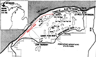 1965 (June, July) – The Michigan legislature passes a bill in June, sponsored by Sen. Joe Mack (Ironwood) and Rep. Russell Hellman (Dollar Bay), prohibiting the Michigan Conservation Commission from continuing its policy of forbidding any westerly extension of M-107 from Lake of the Clouds through the western portion of Porcupine Mountains Wilderness State Park. Gov. George Romney takes a personal tour of the park on July 1, including a six-mile hike from Lake of the Clouds to the Summit Peak Overlook, a visit to the Presque Isle River waterfalls and a helicopter tour of the park from the air to help him decide whether or not to sign or veto the legislation. Western U.P. civic leaders, business owners, lawmakers and news editors have been strongly campaigning for the "completion" of M-107 for several decades. Romney vetoes the bill, which was sponsored by Ironwood's State Senator Joseph Mack on July 21 which, along with the completion of South Boundary Rd at the edges of the park, seems to answer the question once and for all as to "completing" M-107 through the park. See map: M-107: Proposed Westerly Extension (1965). 1965 (June, July) – The Michigan legislature passes a bill in June, sponsored by Sen. Joe Mack (Ironwood) and Rep. Russell Hellman (Dollar Bay), prohibiting the Michigan Conservation Commission from continuing its policy of forbidding any westerly extension of M-107 from Lake of the Clouds through the western portion of Porcupine Mountains Wilderness State Park. Gov. George Romney takes a personal tour of the park on July 1, including a six-mile hike from Lake of the Clouds to the Summit Peak Overlook, a visit to the Presque Isle River waterfalls and a helicopter tour of the park from the air to help him decide whether or not to sign or veto the legislation. Western U.P. civic leaders, business owners, lawmakers and news editors have been strongly campaigning for the "completion" of M-107 for several decades. Romney vetoes the bill, which was sponsored by Ironwood's State Senator Joseph Mack on July 21 which, along with the completion of South Boundary Rd at the edges of the park, seems to answer the question once and for all as to "completing" M-107 through the park. See map: M-107: Proposed Westerly Extension (1965). |
|
| c.1970s – While a date of cancellation for the portion of M-107 proposed to continue west from Lake of the Clouds is not known, the "line on the map" survived into the 1970s before finally being officially dropped by the State Highway Dept. | |
| 1975 (April) – The concept of extending M-107 from its terminus in Porcupine Mountains Wilderness State Park at Lake of the Clouds westerly into Gogebic Co to the Presque Isle River area again crops up, this time due to a serious push by the Michigan Dept of Natural Resources and Gov. William Milliken's office to have all of M-107 from South Boundary Rd westerly to Lake of the Clouds abandoned as both a state trunkline and as a public roadway and turned over to DNR control as a park road, where state park entry fees would be required to traverse the segment of roadway. The backlash against the proposal reignites the still-smouldering local resentment over the still "incomplete" M-107 across the park. This time, however, the Western Upper Peninsula Planning & Development Region (WUPPDR) studies rerouting M-107 onto South Boundary Rd as one way to increase highway access to the region. Agitation for "completing" the route would simmer for another several years before dying down by the end of the 1970s. | |
| 2008 (June 4) – The entire 9.58 mile route of M-107, in existence for 73 years as a state trunkline highway and even pre-dating the Porcupine Mountains Wilderness State Park by a decade, is transferred to county control. | |
| Controlled Access: | No portion of former M-107 upon decommissioning existed as freeway or expressway. |
| NHS: | No portion of former M-107 was on the National Highway System (NHS). |
| Memorial Highway: | The following Memorial Highway designation was officially assigned to the entirety of former M-107 by the Michigan Legislature:
|
| Photographs: |
|
| Weblinks: |
|
| Back to M-106 | Route Listings Home | On to Former M-108 |