| Southern Terminus: |
I-75 at Exit 352 six miles north of St Ignace at Rogers Park |
| "Northern" Terminus: |
M-28 three miles south of downtown Newberry (see "Notes" below) |
| Length: |
96.071 miles |
| Maps: |
Route Map of M-123 |
| Notes: |
The route of M-123 is rather interesting in that from I-75 to Paradise it is essentially a north-south highway, but then heads westerly from Paradise through the Tahquamenon Falls area, then arcs southwesterly and southerly into Newberry, becoming a north-south highway (or south-north highway, as it may be) at that point. Thus, the "northern terminus" of the route, while north of the southern terminus, is south of nearly half of the length of the route and quite far west of the the southern terminus as well! (See Map.) |
| |
 M-123 is one of Michigan's "directionally-challenged" routes, in that its cardinal directions change at some point along the route. While most of these kinds of routes change from either being north–south to east–west or vice versa, M-123 is one of just two Michigan state highways—M-22 in the Leelanau Peninsula is the other—which essentially doubles-back on itself. But whereas M-22 at its "double-back point" in Northport features no cardinal directions on the route signs (e.g. so the motorist isn't foreced to choose between "SOUTH M-22" or "SOUTH M-22"), at M-123's directional change location at the blinker light in Paradise, both directions are actually signed as "SOUTH M-123." M-123 is one of Michigan's "directionally-challenged" routes, in that its cardinal directions change at some point along the route. While most of these kinds of routes change from either being north–south to east–west or vice versa, M-123 is one of just two Michigan state highways—M-22 in the Leelanau Peninsula is the other—which essentially doubles-back on itself. But whereas M-22 at its "double-back point" in Northport features no cardinal directions on the route signs (e.g. so the motorist isn't foreced to choose between "SOUTH M-22" or "SOUTH M-22"), at M-123's directional change location at the blinker light in Paradise, both directions are actually signed as "SOUTH M-123."
|
| |
This highway serves as a popular route for tourists, directly connecting I-75 north of St Ignace with Tahquamenon Falls State Park, featuring two large waterfalls—the second or third most voluminous waterfalls east of the Mississippi River (Niagara being first, Cohoes being the second... when water is actually flowing over it!). M-123 also provides access to other points of interest, such as the community of Paradise, Whitefish Point Lighthouse & Maritime Museum, Crisp Point Lighthouse, the Curley Lewis Scenic Byway, the Tahquamenon Logging Museum, and the community of Newberry. |
| |
Although the northern terminus of US-23 and the southern terminus of M-123 are only separated by 13.6 miles and those termini are essentially due north and south of each other, M-123 and US-23 are completely unrelated routes, having absolutely nothing to do with each other. |
| |
In the late-1930s and into the 1940s (and possibly beyond), the original long-term State Highway Dept plans had M-123 continuing north from its earliest terminus at the logging ghost town of Emerson (at the mouth of the Tahquamenon River) through Paradise to the Whitefish Point area, then heading westerly along the Lake Superior shoreline past Muskallonge Lake in Luce Co to M-77 at Grand Marais and a connection with another proposed shoreline route connecting Grand Marais with Munising to the west. While discussed as recently as the 1990s, such a Lake Superior shoreline route has never advanced beyond the discussion stages. |
| |
In "State Trunkline Needs, 1960–1980," a set of maps prepared by the State Highway Dept's Office of Planning, Programming Division in 1960 showing possible additions, upgrades and improvements to the state trunkline system over the ensuing twenty years, MSHD staff recommended no changes to the route of M-123—as it existed at that time. In 1960, the northern terminus of M-123 was at the "hamlet" of Emerson at the mouth of the Tahquamenon River in northwestern Chippewa Co. It had not yet been extended to Paradise, then westerly and southwesterly past the Lower and Upper Tahquamenon Falls and onward to Newberry. Two interesting notes, however. First, it would be within a year that the State Highway Dept would announce plans to extend M-123 to the Tahquamenon Falls and another year later when it would achieve its current routing, although department planners had no inkling of this in 1960 and did not include this on their planning maps! Second, the 1960 MDSH planning maps had M-117 (which, at the time began at Four Mile Corner four miles north of Newberry and continues south through Newberry and then onward toward Engadine) planned to be turned back to local control between Four Mile Corner (present-day jct of M-123 & H-37/CR-407) and McMillan Ave in downtown Newberry, leaving the northerly M-117 "stub" from M-28 serving just Newberry from M-28. Not only did this jurisdictional transfer not occur, this segment proposed to be transferred is now part of present-day M-123! |
| History: |
1927 (Mar 21) – The chairmain of the Chippewa Co Road Commission, A.J Short, formally requested State Aid from the State Administrative Board for a roadway beginning at M-48 in Trout Lake and continuing notherly through Strongs and then onward toward Tahquamenon Falls. Short related to the Ad Board how the Tahquamenon Falls were a wonderful tourist attraction and an improved roadway was necessary to facilitate tourist traffic. |
| |
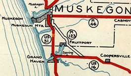 1929 (Dec 2) – A 12.7-mile long trunkline route is officially established from US-16 at Nunica in northern Ottawa Co northwesterly into Muskegon Co, through Fruitport and on into Musekgon Heights to the cnr of Peck St & Sherman Blvd, utilizing the alignment of the recently-abandoned Grand Rapids, Grand Haven and Muskegon Railway, an electric interurban line linking Grand Rapids and Muskegon, with a spur into Grand Haven. At this time, no physical roadway runs along the route and only the old interurban right-of-way, sans tracks, exists. Initially, no work is done to convert the route into a driveable highway, but the future highway route is assigned the M-123 route designation. (See map excerpt—from a 1929 State Highway Department map.) 1929 (Dec 2) – A 12.7-mile long trunkline route is officially established from US-16 at Nunica in northern Ottawa Co northwesterly into Muskegon Co, through Fruitport and on into Musekgon Heights to the cnr of Peck St & Sherman Blvd, utilizing the alignment of the recently-abandoned Grand Rapids, Grand Haven and Muskegon Railway, an electric interurban line linking Grand Rapids and Muskegon, with a spur into Grand Haven. At this time, no physical roadway runs along the route and only the old interurban right-of-way, sans tracks, exists. Initially, no work is done to convert the route into a driveable highway, but the future highway route is assigned the M-123 route designation. (See map excerpt—from a 1929 State Highway Department map.) |
| |
1930 (June 30) – The 1.5-mile stretch of Getty St from Airline Hwy (established as a new state trunkline route M-123 seven months prior) northerly to Sherman Blvd east of downtown Muskegon Heights (southeast of Muskegon) is established as a state trunkline route—the first step in creating a "Muskegon East Belt" to route through traffic out of downtown Muskegon—although no roadway exists between Norton Ave and Broadway Ave and the remainder of the segment still needs to be rebuilt to state trunkline standards. |
| |
1932 (Oct 29) – The remainder of the new "Muskegon East Belt" bypassing downtown Muskegon is established as a state trunkline route, consiting of the 3.5 miles of Getty St from Sherman Blvd northery to Marquette Ave and westerly along Marquette Ave to US-31/Ottawa St northeast of downtown. The new Getty–Marquette trunkline route is assigned the M-123 designation, meaning the future highway designated M-123 now begins at US-16 at Nunica and continues northwesterly through Fruitport via Airline Hwy into Norton Twp where it turns northerly along Getty St and westerly via Marquette Ave to a terminus at US-31. |
| |
1933 (Fall)  – By the Fall of 1934, the established (but not-yet-constructed) trunkline route from Nunica through Fruitport into Muskegon Heights and Muskegon is redesignated as M-126. In the end, the M-123 designation along this route is only used during the planning process and never actually signed along the route. – By the Fall of 1934, the established (but not-yet-constructed) trunkline route from Nunica through Fruitport into Muskegon Heights and Muskegon is redesignated as M-126. In the end, the M-123 designation along this route is only used during the planning process and never actually signed along the route. |
| |
1934 – A ten-mile stretch of new roadway is constructed as Federal Forest Highway 9 (FFH-9) in western Chippewa Co, from M-28 one mile south of Eckerman northerly to Sec 18, T47N R6W (just south of East-and-West Rd), 9 miles north of Eckerman. While not officially established as a state trunkline route, this nearly 10-mile long Forest Highway is constructed along the route of what is to become M-123 early the next year. |
| |
1935 (Jan 7) – The ten miles of FFH-9 highway built in 1934, plus 6.3 additional miles from south of East-and-West Rd northerly to the mouth of the Tahquamenon River at the community of Emerson are assumed into the state trunkline system and designated M-123. The highway is only maintained for the first 9.6 miles north of M-28, though, with the remainder to Emerson continuing to be maintained by the county as a county road. |
| |
1937 (Aug 30) – The official trunkline routing for M-123 from Eckerman in western Chippewa Co had the highway running due southeasterly from Eckerman to M-28, while it used the previously-constructed highway running due southerly to M-28. On this date, the proposed southeasterly alignment is cancelled and the due southerly route is officially assumed into the trunkline system. |
| |
1939 – The existing ten (maintained) miles of M-123 are completely hard-surfaced. |
| |
1954 (May 15) – The length of M-123 is increased by 33.5 miles from M-28 south of Eckerman to US-2 north of St Ignace. From M-28 southerly to Trout Lake, 10.5 miles of new trunkline are established. At Trout Lake, M-123 is signed concurrently with M-48 for approximately one mile before again striking out southeasterly on 22.0 miles of newly-established trunkline via Moran and Allenville, terminating at US-2 at Rogers Park, 8 miles north of downtown St Ignace. All 33.5 miles of new trunkline mileage are gravel-surfaced. The State Highway Dept announces that M-123 markers will be placed along the new segment of M-123 "in time for early summer traffic." |
| |
1954 – In addition to the southerly extension noted above, the April 1 edition of the official highway map indicates M-123 is extended (as a signed route) northerly to the Tahquamenon River bridge at Emerson. This 6.5-mile long segment has officially been part of the established route of M-123 since January 1935, although the State Highway Dept has only maintained (and signed) the route to a point 9.6 miles north of Eckerman Corner since that time. However, the October 1 map shows the northernmost five miles of this new "extension" once again not depicted as a state trunkline route and assumedly maintained as a county road (the mapped extension to the Tahquamenon River bridge at Emerson was likely a cartographic error). A such, by the end of 1954, the signed route of M-123 settles in for a net gain (from 1953) of 1½ miles. |
| |
1954 (Aug) – A 4.5-mile long project to pave Tahquamenon Falls Rd from Paradise westerly toward Tahquamenon Falls is completed and opened to traffic. Grading and graveling was completed on this segment approximately three years prior. It is anticipated this segment of highway may someday become part of the state trunklne route of M-123 toward Tahquamenon Falls. |
| |
1957 – The northerly extension of 1954 to the Tahquamenon River bridge at Emerson is shown again on official maps starting this year. It seems as if this portion of the route is now fully signed and maintained as part of M-123, event though it had been established this far north in 1935. |
| |
1957 (Dec 26) – M-123 is realigned just south of the Tahquamenon River in Chippewa Co. A 1.3-mile long direct routing replaces a 1.7-mile long curve, with the former route being partially turned back to local control and partially abandoned as a public way. (One State Highway Dept source, however, indicates this transfer may have take place on Dec 1.) Paving on this segment is completed during the following year. |
| |
1961 (Feb 8) – The State Highway Dept announces plans to extend both M-117 and M-123 via existing county roads to reach Tahquamenon Falls, which are two of the top tourist attractions in the Upper Peninsula. |
| |
1961 (Nov 15) – Two sharper curves along M-123 at Castle Rock Rd and at the hamlet of Allenville are replaced by more sweeping curves. Much of the former route is obliterated and removed as a public roadway. |
| |
1962 (May 18, July 1) – After strongly lobbying State Highway Commissioner John C. Mackie to provide trunkline access to Tahquamenon Falls State Park, Joseph P. Rahilly of Newberry, member of the State Conservation Commission, finally achieves his goal when the State Highway Dept plans to extend M-123 north from its current terminus to Paradise, then westerly through the state park, then southwesterly to Four Mile Corner north of Newberry at the northern terminus of M-117. There, M-123 will supplant the M-117 designation southerly through Newberry to a new terminus at M-28 at Newberry Corner. The 37.79 miles of new M-123 trunkline in Chippewa and Luce Cos is officially established on May 18 while the signing of the new route and the re-signing of M-117 between Four Mile Corner and M-28 to M-123 occurs by July 1. The concurrent M-28/M-117 between Newberry Corners and Deweys Corner southwest of Newberry becomes just M-28 when the new northern terminus of M-117 becomes M-28 at Deweys Corner. |
| |
1962 – M-123 is now fully paved throughout. The last two unpaved segments of M-123 which are hard-surfaced this year are:
- From the community of Moran in central Mackinac Co northwesterly to the Mackinac/Chippewa Co line, and
- From the community of Trout Lake in southwest Chippewa Co northerly to M-28 at Eckerman Corner.
|
| |
1963 (Dec 5) – With the completion of the I-75/US-2 freeway northerly from M-123 toward Rudyard, the 0.2-mile portion of M-123 from the new freeway to the former US-2 along H-63 is cancelled as a state trunkline. |
| |
1966 – The segment of M-123 from M-28 at Eckerman Corner northerly to Paradise (as well as the portion of Whitefish Point Rd from M-123 at Paradise northerly to the end of the road at Whitefish Point) is titled the "Gitchi Gumee Trail" by local interests "in an effort to point out the historical and legendary aspects of the area." |
| |
1998 – The 26.9 miles of M-123 from Co Rd 500 in eastern Luce Co (approx 4½ miles west of Upper Tahquamenon Falls) easterly through Paradise then southerly to Galloway Creek at the southern boundary of Tahquamenon Falls State Park are designated as the Tahquamenon Scenic Heritage Route. |
| |
2007 (Nov 9) – The Tahquamenon Scenic Heritage Route is expanded from its original 26.9 length as designated in 1998 to encompass the entire 62.4-mile portion of the route north of M-28, from the northern terminus south of Newberry to M-28 at Eckerman Corner. |
| Controlled Access: |
No portion of M-123 exists as freeway or expressway. |
| NHS: |
No portion of M-123 is on the National Highway System (NHS). |
| Circle Tour: |
 Lake Superior Circle Tour – From northern terminus at M-28 south of Newberry to jct M-28 at Eckerman Corner south of Eckerman in western Chippewa Co. Lake Superior Circle Tour – From northern terminus at M-28 south of Newberry to jct M-28 at Eckerman Corner south of Eckerman in western Chippewa Co. |
| Pure Michigan Byway: |
 Tahquamenon Scenic Byway – The portion of M-123 north of M-28 (from the northern terminus south of Newberry to M-28 at Eckerman Corner). This the name of this Scenic Heritage Route first evolved into the Tahquamenon Scenic Heritage Route. Then as the entire Heritage Routes program transitioned to the Pure Michigan Byways branding in 2015, this route was one of the first to similarly rebrand as the Tahquamenon Scenic Byway. Tahquamenon Scenic Byway – The portion of M-123 north of M-28 (from the northern terminus south of Newberry to M-28 at Eckerman Corner). This the name of this Scenic Heritage Route first evolved into the Tahquamenon Scenic Heritage Route. Then as the entire Heritage Routes program transitioned to the Pure Michigan Byways branding in 2015, this route was one of the first to similarly rebrand as the Tahquamenon Scenic Byway. |
| Photographs: |
|
| Weblinks: |
|
| |
|