| Southern Terminus: |
Cedarville at M-134 |
| Northern Terminus: |
BS I-75 in southern Sault Ste Marie (at cnr Ashmun St & Interstate 75 Business Spur) |
| Length: |
33.159 miles |
| Maps: |
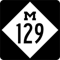
Route Map of M-129 |
| Notes: |
One of four north-south trans-peninsular M-numbered state highways in the Upper Peninsula. M-129 had been M-12 in the pre-US Highway days, and later became the original routing of US-2 in this area before the more modern and shorter Mackinac Trail routing was completed. The highway's first post-US-2 designation was M-121 before it was redesignated as M-5, but was later 'upped by eight' from its old route number to become M-129. |
| |
Over 76% of M-129 travels along Michigan's Principal Meridian, while the remainder runs parallel to the Meridian, exactly ½ mile east of it. The Michigan Meridian, located at 84° 21' 53" W longitude, is the primary north-south reference line for all land surveys in the entire State of Michigan and that portion of Michigan that has been occupied by the "state" of "Ohio" since 1835 (e.g. the Toledo Strip). One of the road names for M-129 for the portion running along the Meridian is, indeed, Meridian Rd. And, for those with a working knowledge of the relative position of M-129 within the Upper Peninsula, it becomes obvious just how much of the U.P. exists west of the Principal Meridian and how little of it sits to the east! |
| |
There have been three iterations of M-129 since the 1920s, all in the Upper Peninsula. The first existed in the Western U.P. from around 1927 until it swapped places with M-64 in mid-1931 to bring the simultaneous end of the first and debut of the second iterations. The second M-129 lasted four years until it was replaced by an extened M-26 routing. The third and current iteration of M-129 dates to late 1939 when it replaced what had been designated M-5 between Cedarville and Sault Ste Marie when the State Highway Department decided to reserve all single-digit route designations for a future system of "superhighways" (e.g. likely a freeway or tollway system). That system never came to fruition, as World War II interrupted a great many highway-building plans around the world and then, in the 1950s, the Interstate Highway System ended up filling the role the State Highway Department likely envisioned for those single-digit route numbers. |
| |
In "State Trunkline Needs, 1960–1980," a set of maps prepared by the State Highway Dept's Office of Planning, Programming Division in 1960 showing possible additions, upgrades and improvements to the state trunkline system over the ensuing twenty years, MSHD staff recommended absolutely no changes to the route of M-129. (It, apparently, was perfect as it was!) In fact, the only recommended change which would have affected the route of M-129 was to have been the loss of the concurrent M-48 designation in the Pickford area, but even that change never came to fruition, thus M-129 remains today essentially the same as it was in 1960. |
| History: |
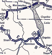 1927 – Several official and quasi-official sources indicate the first iteration of M-129 debuts on a short spur trunkline route beginning at US-2 five miles east of Marenisco in Gogebic Co running easterly to the Gogebic Co Park at the southern tip of Lake Gogebic, then northerly along the west shore of the lake to Lake Gogebic State Park along present-day M-64. Interestingly, the Official State Highway Department Trunkline Determination maps make no mention of this spur route and they indicate this route was not assumed into the trunkline system until July 1, 1931! 1927 – Several official and quasi-official sources indicate the first iteration of M-129 debuts on a short spur trunkline route beginning at US-2 five miles east of Marenisco in Gogebic Co running easterly to the Gogebic Co Park at the southern tip of Lake Gogebic, then northerly along the west shore of the lake to Lake Gogebic State Park along present-day M-64. Interestingly, the Official State Highway Department Trunkline Determination maps make no mention of this spur route and they indicate this route was not assumed into the trunkline system until July 1, 1931! |
| |
1929 (Dec 2) – A new 9.3-mile long trunkline is established beginning at US-2 in Marenisco and running southerly to the Wisconsin state line at Winegar (present-day Presque Isle), Wisc. This new route is given the designation of M-129 and it can be assumed the five miles of US-2 between Marenisco and the existing M-129 spur route to Lake Gogebic State Park is signed concurrently with M-129 at this time. |
| |
1930 (Dec 2) – A 19.0-mile long segment of state trunkline highway route in western Ontonago Co from M-28 at Bergland northerly to the Lake Superior shore at Silver City, then easterly for two miles to the western end of existing M-35 (present day M-64) is officially assumed into the state trunkline system and designated (initially) as an extension of M-35. However, this route is not yet constructed or open to traffic and, as such, is not signed as part of any trunkline route. At some point soon after (between now and early 1931), it is re-designated as a northerly extension of M-129. |
| |
1931 (July 1) – A 10.2-mile long state trunkline route beginning at the eastern jct of US-2 & M-129 (present-day cnr M-64 & CC Rd) northeast of Marenisco and proceeding easterly to the Gogebic Co Park, then northerly up the western shore of Lake Gogebic to the Gogebic/Ontonagon Co line. It encompasses the approximately 6½ miles of M-129 already apparently signed as M-129 from US-2 northerly to Lake Gogebic State Park as well as approximately 3¾ mile of unbuilt highway from the state park to the county line which is proposed to become a northerly extension of M-129 to M-28 at Merriweather west of Bergland in Gogebic Co. |
| |
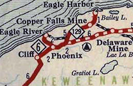 1931 (Aug–Sept) – By August or September, the M-129 and M-64 designations in the western Upper Peninsula are flip-flopped, trading places... for reasons which have not been made apparent to date. Up to this time, M-64 has been designated along the five-mile long "Eagle Harbor Cut-off" in Keweenaw Co running from US-41 between Phoenix and Central northeasterly through Copper Falls to Eagle Harbor on Lake Superior. This route had formerly been one of the three M-15 spurs in Keweenaw Co prior to the arrival of US-41 in 1927, then was designated as M-9 from 1927–28 before it was signed as M-64 from 1928–1931. The open and signed portion of M-129 from the Wisconsin state line northerly through Marenisco to Lake Gogebic State Park is re-signed as M-64 (and, simultaneously, the portion of M-35 from Ontonagon westerly along the Lake Superior shoreline toward Silver City is also redesignated as M-64, leaving that route as a disconnected, two-segment route at this point). At the same time, M-129 is designated along the five miles of what had been M-64 from US-41 to Eagle Harbor in Keweenaw Co. Thus, the first iteration of M-129 comes to an end at the same moment the second iteration begins. 1931 (Aug–Sept) – By August or September, the M-129 and M-64 designations in the western Upper Peninsula are flip-flopped, trading places... for reasons which have not been made apparent to date. Up to this time, M-64 has been designated along the five-mile long "Eagle Harbor Cut-off" in Keweenaw Co running from US-41 between Phoenix and Central northeasterly through Copper Falls to Eagle Harbor on Lake Superior. This route had formerly been one of the three M-15 spurs in Keweenaw Co prior to the arrival of US-41 in 1927, then was designated as M-9 from 1927–28 before it was signed as M-64 from 1928–1931. The open and signed portion of M-129 from the Wisconsin state line northerly through Marenisco to Lake Gogebic State Park is re-signed as M-64 (and, simultaneously, the portion of M-35 from Ontonagon westerly along the Lake Superior shoreline toward Silver City is also redesignated as M-64, leaving that route as a disconnected, two-segment route at this point). At the same time, M-129 is designated along the five miles of what had been M-64 from US-41 to Eagle Harbor in Keweenaw Co. Thus, the first iteration of M-129 comes to an end at the same moment the second iteration begins. |
| |
1933 (Jul 12) – A new 13.8-mile state trunkline highway is established from Eagle Harbor easterly along the Lake Superior shore to US-41 at Copper Harbor and is designated as an easterly extension of M-129, although final construction on the route itself will not be fully completed until the summer of 1934. The 0.4-mile segment of the former M-129 through Eagle Harbor along Front St and North St to the Eagle Harbor Lighthouse point is redesignated as M-206. |
| |
1934 (Oct 13) – The final 3¾-mile segment of the M-129 lakeshore drive between Eagle Harbor and Copper Harbor is completed and opened to traffic from Agate Harbor easterly to just east of present-day Hebard Park. Approximately ten miles of the 13.8-mile segment had been completed for over a year as work on the segment progressed for either end. The scenic drive is expected to be extremely popular with tourists. |
| |
1935 (Summer) – Between July and September, the M-26 designation is extended northeasterly concrrently with US-41 from Calumet/Laurium to central Keweenaw Co, then northeasterly supplanting M-129 to Eagle Harbor and easterly to Copper Harbor, where it now terminates. Thus, the M-129 designation is completely decommissioned in the process and bringing the second iteration of the M-129 routing to a close. |
| |
1939 (Dec) – By December 1939, with the State Highway Dept in a frenzy to remove all single-digit state route designations and place them in reserve for a planned "Superhighway network," all of M-5 in Mackinac & Chippewa Cos from Cedarville northerly to US-2 in Sault Ste Marie is redesignated M-129. (Similarly, the route near the new M-129's southern terminus is redesignated from M-5 to M-134 at this same time.) |
| |
1960 – The final stretch of gravel-surfaced M-129, just south of Sault Ste Marie, is paved. |
| |
1963 (Jan 25) – The 0.2-mile spur of M-129 in Cedarville south of M-134 into the center of town is turned back to local control, moving the southern terminus of M-129 north to M-134. |
| |
1967 (Oct 27) – A minor realignment at the northern end of M-129 bends the highway westerly to ⊤-intersection into BS I-75 in Sault Ste Marie at a 90° angle. The route of M-129 shrinks by 0.082 mile in the process (the new route is 0.088 miles in length, while the cancelled route length is 0.170 mile). |
| Controlled Access: |
No portion of M-129 exists as freeway or expressway. |
| NHS: |
No portion of M-129 is on the National Highway System (NHS). |
| Circle Tour: |
 Lake Superior Circle Tour: From the southern jct of M-48 south of Pickford to the northern terminus of M-129 at BS I-75 in Sault Ste Marie. Lake Superior Circle Tour: From the southern jct of M-48 south of Pickford to the northern terminus of M-129 at BS I-75 in Sault Ste Marie. |
| Memorial Highway: |
At present, no portion of M-129 has been designated as part of a Memorial Highway. |
| Photographs: |
|
| Weblinks: |
|
| |
|