

Historic Auto Trails
 Before
the Interstates in 1956, before the coming of the US Highways in 1926,
before the numbering of the familiar "M"-numbered routes in Michigan
in 1918-19, there were the Auto Trails. These routes were designated
with names—sometimes fanciful, oftentimes utilitarian or descriptive—and
marked with colored bands on telephone and eletric poles. According to
some sources, the first Auto Trail had its beginning in 1911 in Iowa
and spread rapidly from there.
Before
the Interstates in 1956, before the coming of the US Highways in 1926,
before the numbering of the familiar "M"-numbered routes in Michigan
in 1918-19, there were the Auto Trails. These routes were designated
with names—sometimes fanciful, oftentimes utilitarian or descriptive—and
marked with colored bands on telephone and eletric poles. According to
some sources, the first Auto Trail had its beginning in 1911 in Iowa
and spread rapidly from there.
According to Dave Schul's North American Auto Trails website: "A few of the trails achieved national or international fame, and allowed adventurous people to get from coast to coast if the mood struck them. Others performed the same duties at a more localized level, showing drivers the way from the city to the mountain resorts and back."
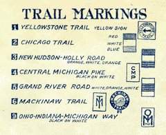
Within only a few years, the proliferation of "marked" highways was reaching crisis proportions. Countless automobile clubs, tire companies, oil companies and tourist associations erected signs along randomly-chosen routes. Sometimes these routes would veer far from the best or most direct path only to pass through a city which paid a fee to have the marked route run though the center of town. Michigan was home to many of these trails.
 The first state to understand the problem and propose a solution was
Wisconsin, Michigan's neighbor to the west. In 1917, the Wisconsin State
Legislature went so far as to enact a law which prohibited the marking
and posting of any "trails" within the state without prior authorization
from the state. By 1919, there was only one such "trail," the Yellowstone
Trail, marked within Wisconsin. As a replacement for the multitude of
marked auto trails, the Wisconsin legislature, authorized the creation
and signing of a numbered highway system. Michigan had also recognized
the problem and followed closely behind Wisconsin as the second state
marking and signing its state trunklines with numbers in 1918.
The first state to understand the problem and propose a solution was
Wisconsin, Michigan's neighbor to the west. In 1917, the Wisconsin State
Legislature went so far as to enact a law which prohibited the marking
and posting of any "trails" within the state without prior authorization
from the state. By 1919, there was only one such "trail," the Yellowstone
Trail, marked within Wisconsin. As a replacement for the multitude of
marked auto trails, the Wisconsin legislature, authorized the creation
and signing of a numbered highway system. Michigan had also recognized
the problem and followed closely behind Wisconsin as the second state
marking and signing its state trunklines with numbers in 1918.
The Auto Trails soon began fading as additional states began to follow suit and number and sign their state trunklines. The death knell for the Auto Trails was likely the creation of the US Highway system in 1926. Only a few states had no numbered and signposted state highways in the mid-1920s, but the US Highway system drove the final nail in the Auto Trails' coffin.
After the colored bands had faded from roadside utility poles and the state and US Highway route numbers became firmly engrained in motorists' minds, vestiges of the old Auto Trails remained. Even today one can find segments of roads named "Dixie Highway," "Grand River Ave" and "Mackinac Trail" around the state, hinting to those roads' link to the past.
For a listing of the Historic Auto Trails which once criss-crossed Michigan, please proceed to the Auto Trails Listing page...
Additional Information
- North American Auto Trails – by Dave Schul (archived). "This site is a catalog of marked auto trails that were found in the United States and Canada in the 1910s and 1920s," according to Dave.
- From Names to Numbers: The Origins of the U.S. Numbered Highway System – an in-depth article by Richard F. Weingroff of the Federal Highway Administration (FHWA) on the beginnings of the US Highway System.
- Whatever Happened to the Dixie Highway? – an excellent (archived) resource regarding the historic Dixie Highway, which had two main legs and several auxillary routes within Michigan.
- Auto Trail Links – a page with dozens of Auto Trail-related links from the American Roads website.