

| Back to Previous Route: I-696 |
 |
On to: Unsigned Routes |
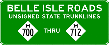
| With the transfer of Belle Isle Park from the City of Detroit to the Michigan Dept of Natural Resources to become a State Park under a 30-year lease (with two 15-year renewal options), all roads on the island became unsigned state trunkline highways. The 13 unsigned routes are presented below followed by general notes, historical information and weblinks after. | |
| UNSIGNED M-700: | |
| Northern Terminus: | Northern end of Gen Douglas MacArthur Bridge at cnr East Grand Blvd & E Jefferson Ave |
| Eastern Terminus: | Cnr Riverbank Dr (M-700/M-712) & Inselruhe Ave (M-708) on the north shore |
| Length (M-700): | 5.545 miles |
| Roads Followed: | Douglas MacArthur Bridge, Sunset Dr, The Strand, Lakeside Dr, Riverbank Dr |
| Notes (M-700): | Unsigned M-700 not only includes the General Douglas MacArthur Bridge, which spans the north channel of the Detroit River giving access to Belle Isle from the mainland, it nearly encircles the entire island on all of the shoreline roadways with the exception of the last two "blocks" of Riverbank Dr from Inselruhe Ave (M-708) to the foot of the MacArthur Bridge. Why MDOT chose to not give one (unsigned) route designation to the entirety of the outermost roadway on the island is somewhat puzzling, unless doing so—and causing it to intersect itself and, therefore causing there to be a three-legged M-700 junction—would cause issues with their asset-tracking software or other database programs. (see map) |
| The portion of Unsigned M-700 on the island (the portion which is not on the Gen Douglas MacArthur Bridge) is one-way only in a counter-clockwise direction. | |
| UNSIGNED M-701: | |
| Western Terminus: | Cnr Casino Way (M-704) & Central Ave, approximately 625 feet north of the Belle Isle Casino |
| Eastern Terminus: | Lakeside Dr (M-700) on the east end of the island, between the Blue Heron Lagoon Trailhead and the Belle Isle Nature Center |
| Length (M-701): | 1.937 miles |
| Roads Followed: | Central Ave across the entire island (see map) |
| Notes (M-701): | Unsigned M-701 follows Central Ave for the entire length of the roadway and is one-way eastbound for its entirety. |
| UNSIGNED M-702: | |
| Southern Terminus: | Cnr The Strand (M-700) & Fountain Dr (M-702) south of the James Scott Mem Fountain |
| Northern Terminus: | Cnr Sunset Dr (M-700) & Fountain Dr (M-702) north of the James Scott Mem Fountain |
| Length (M-702): | 0.286 miles |
| Roads Followed: | The southern and northern legs of Fountain Dr and Fountain Circle around the James Scott Mem Fountain. (see map) |
| Notes (M-702): | Unsigned M-702 follows Fountain Dr as it cuts across the western tip of the island and follows Fountain Circle which encircles the James Scott Memorial Fountain. M-702 is a two-way roadway with the exception of Fountain Circle around the fountain which travels in a counter-clockwise direction (behaving much like a traffic rotary with large fountain in its center). |
| Unsigned M-702 (Fountain Dr) is one of three transverse routes/roads completely crossing the width of the island. (Picnic Way does it in two segments with a jog at Loiter Way while it also bears two separate unsigned route designations. Vista Ave used to, but is now interrupted between Loiter Way [M-705] and Central Ave [M-701] by the abandoned Belle Isle Zoo.) | |
| UNSIGNED M-703: | |
| Western Terminus: | Fountain Dr (M-702) at the circle around the James Scott Mem Fountain |
| Eastern Terminus: | Casino Way (M-704) at the Belle Isle Casino |
| Length (M-703): | 0.126 miles (665.28 feet) |
| Roads Followed: | The eastern leg of Fountain Dr (see map) |
| Notes (M-703): | The street sign on Fountain Circle on Belle Isle at th James Scott Mem Fountain indicates this roadway (Unsigned M-703) is also named Fountain Dr, making it a third, eastern leg of said roadway heading toward the Casino from the Fountain. However, Google Maps labels it as a third, western leg of Casino Way... but Google Maps is so often incorrect, so is anyone surprised? MDOT mapping data also labels it as Fountain Dr. |
| UNSIGNED M-704: | |
| Southern Terminus: | Cnr The Strand (M-700) & Casino Way just south of the Belle Isle Casino |
| Northern Terminus: | Cnr Sunset Dr (M-700) & Casino Way northeast of the James Scott Mem Fountain |
| Length (M-704): | 0.422 miles |
| Roads Followed: | Casino Way in its entirety (see map) |
| Notes (M-704): | The northernmost segment of M-704/Casino Way from Sunset Dr (M-700) to Central Ave (M-701) is one-way only southbound, while the remainer of the roadway is open to two-way travel. |
| Unsigned M-704/Casino Way is one of three transverse routes/roads completely crossing the width of the island. (Picnic Way does it in two segments with a jog at Loiter Way while it also bears two separate unsigned route designations. Vista Ave used to, but is now interrupted between Loiter Way [M-705] and Central Ave [M-701] by the abandoned Belle Isle Zoo.) | |
| UNSIGNED M-705: | |
| Western Terminus: | Cnr Central Ave (M-701) & Muse Rd (M-705) near the former Newsboys Shelter |
| Eastern Terminus: | Cnr The Strand (M-700) & Vista Ave (M-705) at the Rev Samuel Francis Smith Flagpole east of the scoccer field |
| Notes (M-705): | 1.293 miles |
| Roads Followed: | Muse Rd, Loiter Way, Vista Ave (south segment) (see map) |
| Notes (M-705): | Unsigned M-705 is open to two-way travel in its entirety and passes by some of the islands main attractions: the Anna Scripps Whitcomb Conservatory, the Belle Isle Aquarium, the Oudolf Garden, the Nancy Brown Peace Carillion Tower, the Giant Slide, and the Athletic Building. |
| UNSIGNED M-706: | |
| Southern Terminus: | The Strand (M-700) just west of the Dossin Great Lakes Museum |
| Northern Terminus: | Loiter Way (M-705) at the Oudolf Garden west of the Anna Scripps Whitcomb Conservatory |
| Length (M-706): | 0.130 miles (686.40 feet) |
| Roads Followed: | Picnic Way (south segment) (see map) |
| Notes (M-706): | Unsigned M-706 follows the southern segment of Picnic Way, which is not continuous with the northern segment, and serves as a short connector route between Loiter Way and The Strand. It is a two-way roadway. |
| UNSIGNED M-707: | |
| Southern Terminus: | Cnr Loiter Way (M-705) & Picnic Way (M-707) just west of the Oudolf Garden |
| Northern Terminus: | Cnr Riverbank Dr (M-712) & Picnic Way (M-707) at the Belle Isle Boathouse parking lot entrance |
| Length (M-707): | 0.354 miles |
| Roads Followed: | Picnic Way (north and central segments) (see map) |
| Notes (M-707): | Unsigned M-707 follows the northern and central segments of Picnic Way, which is not continuous with the southern segment. The northernmost segment of Picnic Way (Central Ave–Riverbank Dr) is one-way, northbound only, while the central segment is open to two-way travel between Central Ave and Loiter Way. |
| UNSIGNED M-708: | |
| Southern Terminus: | Cnr The Strand (M-700) & Inselruhe Ave (M-708) east of the Dossin Great Lakes Museum |
| Northern Terminus: | Cnr of Riverbank Dr (M-700/M-712) & Inselruhe Ave (M-708) north of the police substation |
| Length (M-708): | 0.403 miles |
| Roads Followed: | Inselruhe Ave in its entirety (see map) |
| Notes (M-708): | Unsigned M-708 follows Inselruhe Ave in its entirety, which is a two-way roadway. Inselruhe Ave is named for the structure along its route now also commonly referred to as "The White House" which was formerly used as the park headquarters for many years. The Greek Revival house was constructed in 1863 by R Stoors Willis who had married the widow of the owner of the island and named it "Inselruhe," meaning "island rest" in German. |
| Unsigned M-708/Inselruhe Ave is one of three transverse routes/roads completely crossing the width of the island. (Picnic Way does it in two segments with a jog at Loiter Way while it also bears two separate unsigned route designations. Vista Ave used to, but is now interrupted between Loiter Way [M-705] and Central Ave [M-701] by the abandoned Belle Isle Zoo.) | |
| UNSIGNED M-709: | |
| Western Terminus: | Riverbank Dr (M-700) at the Belle Isle Beach on the north shore |
| Eastern Terminus: | |
| Length (M-709): | |
| Road Followed: | Oakway Trail in its entirety (see map) |
| Notes (M-709): | |
| UNSIGNED M-710: | |
| WESTERN SECTION: | |
| Western Terminus: | The Strand (M-700) west of the Belle Isle Coast Guard Station on the south shore |
| Eastern Terminus: | |
| EASTERN SECTION: | |
| Western Terminus: | |
| Eastern Terminus: | Lakeside St (M-700) north of the Blue Heron Lagoon Trailhead on the east end of the island |
| Length (M-710): | |
| Roads Followed: | Woodside Dr in its entirety (see map) |
| Notes (M-710): | Unsigned M-710 follows Woodside Dr, which is a two-way road, in its entirety. (Google Maps initially incorrectly showed Woodside Dr as a one-way, eastbound only, roadway, which was incorrect.) |
| UNSIGNED M-711: | |
| Southern Terminus: | Cnr Central Ave (M-701) & Vista Ave (M-711) at the Dante Bust statue |
| Northern Terminus: | Cnr Riverbank Dr (M-700) & Vista Ave (M-711) west of the Belle Isle Beach on the north shore |
| Length (M-711): | 0.054 miles (284.60 feet) |
| Roads Followed: | Vista Ave (north segment) (see map) |
| Notes (M-711): | Unsigned M-711 follows the northern segment of Vista Ave (which MDOT labels as "Vista Dr" in its mapping data), a short, two-way street connecting Central Ave (M-701) and Riverbank Dr (M-700) on the north side of the abandoned Belle Isle Zoo. Vista Ave used to connect through to the south but was severed in the 1980s during a zoo upgrade project. |
| Unsigned M-711 is not only the shortest of the Belle Isle unsigned trunkline routes at 0.054 miles or 284.60 feet, but when considering all "types" of state trunkline routes (signed, unsigned, etc.), it would be the shortest trunkline route in the entire state of Michigan as well. | |
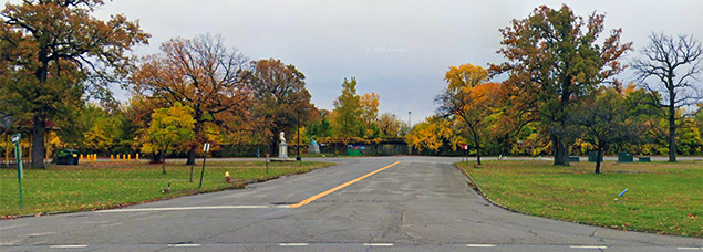 A view of the entirety of Unsigned M-711 looking south from Riverbank Dr (M-700). |
|
| UNSIGNED M-712: | |
| Western Terminus: | Cnr Sunset Dr (M-700) & Riverbank Dr (M-712) at the southern end of the Gen Douglas MacArthur Bridge (M-700) |
| Eastern Terminus: | Cnr Riverbank Dr (M-700/M-712) & Inselruhe Ave (M-708) on the north shore |
| Length (M-712): | 0.514 miles |
| Roads Followed: | Riverbank Dr between Sunset Dr and Inselruhe Ave (see map) |
| Notes (M-712): | Unsigned M-712 consists of the westernmost two "blocks" of Riverbank Dr (between Sunset Dr/the Gen Douglas MacArthur Bridge and Inselruhe Ave) and is the only portion of the island's outer, circumfrencial route which is not part of Unsigned M-700. Why MDOT chose to not give one (unsigned) route designation to the entirety of the outermost roadway on the island is somewhat puzzling, unless doing so—and causing it to intersect itself and, therefore causing there to be a three-legged M-700 junction—would cause issues with their asset-tracking software or other database programs. (see map) |
| Length (Total): | 12.557 miles |
| Map: | Route Map of Belle Isle Roads (Unsigned M-700 – M-712) |
| Notes: | "In 2013, the city of Detroit declared bankruptcy and a State Emergency Manager was appointed by the state government to oversee the city's finances. As part of the process, the state proposed taking over Belle Isle and converting it into a state park. Michigan Governor Rick Snyder signed a lease on October 1, 2013 to lease the park from the city for 30 years; while the city council rejected that offer in mid-October, the Michigan Emergency Loan Board opted for the state's proposal on November 12. It set a 90-day transition period beginning on December 1 to turn the park operations over to the state. As a state park, admittance by car or motorcycle is no longer free, but requires a user to either pay the standard state park user entrance fee or to have a Michigan Recreational Passport sticker on their license plate. There is no charge for those who walk, bicycle or jog to the park." Source: Wikipedia |
|
|
| History: | 2012 (Sept) |
| 2013 (Nov 12) – With the signing of the lease agreement between the State of Michigan and the State Emergency Manager for the City of Detroit, the public roads on Belle Isle automatically become unsigned state trunkline highways, although the "secret" unsigned route designations are probably not assigned to each route by MDOT until sometime in the next year. There are now nearly 13 miles of state-maintained roadway on the island. | |
| 2014 (Fall) – A short segment of The Strand (Unsigned M-700) immediately east of Casino Dr (Unsigned M-704) south of the Belle Isle Casino is realigned to move closer to the shoreline and to decrease the sharpness of a curve in the roadway. | |
| 2020 (Fall) |
|
| 2021 (Aug 12) – Oakway Tr (Unsigned M-709) is closed to vehicular traffic and the removal of the roadway commences as part of a project to replace certain road infrasturcture on the eastern end of Belle Isle with non-motorized trails. The project will also help restore "one of the largest wet-mesic flatwoods in existence and one of only six high-quality occurrences left in Michigan, providing habitat for a variety of rare plants, wildlife species and migrating songbirds, according to the Michigan DNR. Once MDOT completes bridge maintenance activities on the span over the Sylvan Canal (Lake Muskoday outlet) in late 2022, the new replacement trail will open to non-motorized traffic. According to "Belle Isle Flatwoods Restoration" plan maps from August 2018, only short stubs of the eastern- and westernmost ends of existing Oakway Tr will remain to access trailheads. Whether or not these stub roadways will remain designated Unsigned M-709 is unclear at this time. | |
| 2022 (June–July) |
|
| Controlled Access: | No portion of M-700 – M-712 exist as freeway or expressway. |
| NHS: | No portion of M-700 – M-712 are on the National Highway System (NHS). |
| Photographs: | |
| Weblinks: |
|
| Back to I-696 | Route Listings Home | On to Unsigned Routes |