

| Back to Previous Route: M-61 |
 |
On to Next Route: M-63 |
| Western Terminus: | M-140 approximately 2.5 miles east of downtown Eau Claire |
| Southern Terminus: | Indiana state line (connection w/IN SR-23), 3 miles south of Edwardsburg |
| Length: | 28.328 miles |
| Maps: | Route Map of M-62 |
| Notes: | |
 re to US-31, while "established" as a trunkline route, was unbuilt and remained a proposed highway, including a planned St Joseph River span just downstream of the present-day US-31/St Joseph Valley Pkwy bridges. (Also, at this time, M-140 didn't exist—it would be four more years before that highway would come into existence.) The unbuilt segment of M-62 remained on the books until it was officially cancelled as a state trunkline route in early-November 1949. re to US-31, while "established" as a trunkline route, was unbuilt and remained a proposed highway, including a planned St Joseph River span just downstream of the present-day US-31/St Joseph Valley Pkwy bridges. (Also, at this time, M-140 didn't exist—it would be four more years before that highway would come into existence.) The unbuilt segment of M-62 remained on the books until it was officially cancelled as a state trunkline route in early-November 1949.Apparently no official M-62 extension westerly from Eau Claire then existed until planning for the US-31 freeway through Berrien Co begins in earnest. At that point, proposals to connect a western M-62 extension with the new freeway emerged by 1970. A public meeting was even held at Eau Claire High School in 1977 to present the three alternatives the Dept of State Highways & Transportation had come up with for making the connection with the freeway. One route continued M-62 westerly through downtown Eau Claire via Main St then westerly to the new freeway, likely at the present-day Tabor Rd interchange, while the other two either bypassed Eau Claire to the north or south, then returning to the Tabor Rd interchange. The portion of M-62 from M-140 east of Eau Claire easterly to Dowagiac was earmarked for modernization during 1979 and state transportation officials indicated work to extend M-62 through/around Eau Claire and toward the projected US-31 freeway route would likely happen in conjunction with that project. However, to the present-day, the M-62 westerly extension from M-140 either through or bypassing Eau Claire, then on to an interchange with the US-31 freeway has never ocurred. |
|
In "State Trunkline Needs, 1960–1980," a set of maps prepared by the State Highway Dept's Office of Planning, Programming Division in 1960 showing possible additions, upgrades and improvements to the state trunkline system over the ensuing twenty years, MSHD staff recommended a couple changes to M-62 during that timeframe, including:
|
|
| History: | 1913 (Oct 2) – An 18.5-mile new state trunkline route is officially established in Cass Co, beginning at the Indiana state line southwest of Edwardsburg and continuing north along Conrad Rd to present-day US-12, then east-northeasterly via present-day US-12 to Edwardsburg where it turns northeasterly and northerly via present-day M-62 to the southern limits of the Village of Cassopolis. Then from the village limits at the northwestern corner of Cassopolis, the newly-established trunkline route runs generally along the present-day route of M-62 through Lagrange to the eastern limits of the City of Dowagiac. This new trunkline is designated as T.L. 62. |
| 1916 (Mar 28) – T.L. 62 in its entirety is cancelled as a state trunkline route, but is simultaneously re-established with two changes. T.L. 62 now begins at the Indiana state line southeast of Edwardsburg and continues northwesterly along Elkhart Rd to the eastern limits of the Village of Edwardsburg. T.L. 62 re-starts again at the northern Edwardsburg village limits and continues along its 1913–1916 route to Cassopolis. The Cassopolis-to-Dowagiac segment is identical to the 1913 version. (Why the State Highway Dept cancelled the entire trunkline rather than just the portions superseded by other segments is unclear.) | |
| 1919 (July 1) – T.L. 62 is signed in the field as M-62 as all state trunkline highways in Michigan are signed with route markers. Gaps in the route within Edwardsburg, Cassopolis and Dowagiac are signed as M-62 but is not officially under state jurisdiction. | |
| 1919 (Dec 17) – Most of the signed route of M-62 through the Village of Cassopolis is officially established as state trunkline, with the exception of one block of Broadway St downtown. From the southern village limit, the now-state-controlled route of M-62 follows O'Keefe St northerly, South St westerly, then northerly via Broadway St (concurrently with M-60) to Jefferson St. There, M-62 continues northerly for one block as a city-maintained street. State control now resumes at State St (northern jct with M-60) and continues to the western limits of Cassopolis. | |
| 1923 (May 18) – M-62 is realigned from Edwardsburg southerly as the present-day route of the highway is established as a state trunkline route between the state line and the northern limits of the village of Edwardsburg (3.0 miles). This realignment facilitates a connection with what would become Indiana SR-23 in the future. The former 2.7 mile route of M-62 southeasterly from Edwardsburg along Elkhard Rd is turned back to county control. | |
| 1923 (Oct 23) – The route of M-62 in the southern part of Cassopolis is rerouted when Reid St from O'Keefe St westerly to Broadway St and Broadway from Reid northerly to South St is transferred to state control. (M-60—recently extended southwesterly from Cassopolis to Niles is concurrently designated along the portion of Broadway St.) The former route along O'Keefe St from Reid St to South St and via South St from O'Keefe to Broadway is turned back to village jurisdiction. | |
| 1925 (Oct 5) – Most of the signed route of M-62 into the City of Dowagiac is officially established as state trunkline, with the exception of two blocks of Division St downtown. From the eastern village limit, the now-state-controlled route of M-62 follows Division St westerly to the New York Central RR crossing. There, M-62 continues westerly for two blocks as a city-maintained street to its terminus at M-40 (present-day M-51) at Front St. | |
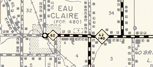
| 1928 (Oct 19) – The State Highway Dept advisory board designates, pending approval by the State Administrative Board, a new, 22-mile long state trunkline route beginning at Dowagiac and continuing westerly through Eau Claire and terminating in Benton Harbor as a westerly extension of M-62. | |
| 1930 (Dec 2) – A 13.8-mile long state trunkline route is established beginning in Cass Co at M-40 (present-day M-51) on the west side of Dowagiac and continuing westerly into Berrien Co, through the Village of Eau Claire and to a terminus at US-31 (present-day M-139) between Berrien Springs and Scottdale. From Laberdy Rd westerly across the St Joseph River to US-31, no roadway exists and the trunkline route itself is not signed west of Old Pipestone Rd in downtown Eau Claire. The State Highway Dept plans to construct a crossing at the St Joseph River to complete the physical highway in the future. This new route becomes a westerly extension of the route of M-62. | |
1931 – Act 131 of 1931—the Dykstra Act—is passed allowing the State Highway Dept to take over control of state highways running into and through incorporated cities, thereby officially incorporating them as state trunkline highways. The following segments of formerly city-controlled streets are established as part of M-62:
|
|
| c.1945-46 – A paving and "straightening" project begun before World War II is completed. The project involves the hard-surfacing of the last eight gravel-surfaced miles of M-62, between Cassopolis and Dowagiac. Some sharp curves are "smoothed" out and about one mile is shaved from the route. | |
| 1948–49 – The 4 miles of M-62 from M-40 at Dowagiac to Indian Lake Rd west of Dowagiac shows up as "gravel-surfaced" on Michigan official highway maps from 1948 into 1949. This portion of the route is re-hard-surfaced by the end of 1949. This is actually not a totally uncommon experience in Michigan in the late-1940s. During the World War II when materials were in short supply, many hard-surfaced roads were not maintained very well, and after the War, there were so many paved highways in bad shape, the State Highway Dept had a tough time resurfacing them all. | |
| 1949 (Nov 4) – All of the officially-established trunkline route of M-62 from downtown Eau Claire at Old Pipestone Rd westerly to US-31/US-33 is cancelled as a state trunkline route. Main St from Pipestone Rd westerly to Hochberger Rd and Staley Rd from Hochberger to Laberdy Rd had never been actually marked or maintained as a state trunkline, while the remainder of the never-built route would remain forever unbuilt. | |
| 1950–53 – The five miles of M-62 from Indian Lake Rd west of Dowagiac into Eau Claire show up as "gravel-surfaced" on Michigan official highway maps beginning in 1950. Most of this segment is re-surfaced by 1952, with the remainder done in 1953. (Same explanation as 1948–49 note above.) | |
| 1957 (June 24) |
|
| 1979 (Apr–Nov) |
|
| 1980 (June 18) |
|
| 1990 (Oct 8) – The route of M-51/M-62 through downtown Dowagiac is realigned when the portion of Division St between Main St and Front St is established as a state trunkline route, while the former route along Main St (from Division St to Front St) and Front St (from Main St to Division St) is cancelled as a state trunkline route and turned back to city control. The realignment results in a shorter and more direct route for both trunklines. The intersection of Main St & Division St is also reconfigured to favor the through trunkline route, requiring eastbound Main St traffic at Division St to make a 90° turn to continue into downtown via Main St. | |
| Controlled Access: | No portion of M-62 is freeway or expressway. |
| NHS: | No portion of M-62 is on the National Highway System (NHS). |
| Memorial Highway: | The following Memorial Highway designation has been officially assigned to part of M-62 by the Michigan Legislature:
|
| Continue on: | |
| Photographs: | |
| Weblinks: |
|
| Back to M-61 | Route Listings Home | On to M-63 |