| Back to Previous Route: M-124 |
 |
On to Next Route: Former M-126 |
| Southern Terminus: | Ohio state line, five south of Erie |
| Northern Terminus: | US-24/Telegraph Rd, five miles north of Monroe |
| Length: | 19.480 miles |
| Maps: | Route Map of M-125 |
| Notes: | M-125 is designated as such since the highway traverses a portion of the former US-25 in Michigan. This highway essentially runs parallel to, and within approximately 1,200–5,000 feet of, US-24 for its entire length. Additionally, US-24/Telegraph Rd, M-125/Dixie Hwy and I-75/Detroit–Toledo Expwy all run in a corridor where the maximum distance between the farthest of the three routes is never more than 2.6 miles. As such, according to internal MDOT sources, M-125 has long been a "turnback candidate" whereby MDOT would prefer to transfer the road to the local authorities and the route would no longer be designated M-125. As the Monroe Co Road Commission has yet to accept jurisdiction over the former route of US-223 running through Ottawa Lake in the southwest corner of the county, which has been unsigned and a jurisdictional transfer candidate since 1977, it is unlikely the County or City of Monroe will be willing recipients of M-125 at any point in the near future. |
| The portion of M-125 through downtown Monroe was designated as one of Michigan's first Historic Heritage Routes. From MDOT: "The City of Monroe in conjunction with MDOT nominated the portion of M-125 which runs through the Old Village Historic District, and is contiguous to the East Elm–North Macomb Historic District, and the Custer Equestrian Monument." | |
There have been three separate iterations, or versions, of M-125 in existence since 1931, all very different types of highways, each in very different parts of the state. They include:
|
|
| In "State Trunkline Needs, 1960–1980," a set of maps prepared by the State Highway Dept's Office of Planning, Programming Division in 1960 showing possible additions, upgrades and improvements to the state trunkline system over the ensuing twenty years, there was no recommendation from MSHD staff for the route of M-125—as in 1960, there was no M-125! The previous iteration of the route in Bay Co had been turned back to county control in 1957 and the current iteration would not exist for another 13 years! | |
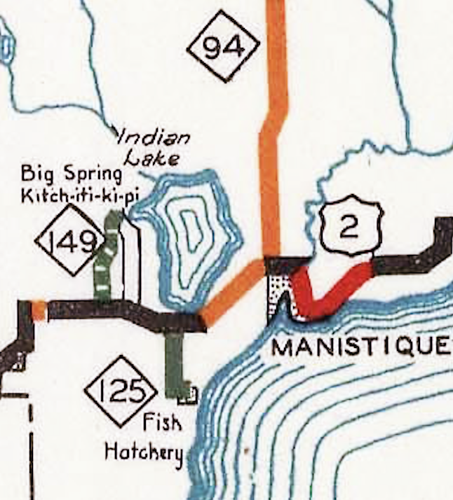
| History: |  1931 (June 19, Aug 31) – On June 19, the State Administrative Board approves a new short spur highway from US-2 west of Manistique to serve the new Thompson State Fish Hatchery as part of 30 additional miles of roadway approved to be added to the trunkline sytem. (At this time, US-2 runs along present-day Co Rd 442 west of Manistique via Cooks instead of the present-day shoreline routing—see map at right.) Then 10½ weeks later on August 31, a new 1.5-mile long spur route, designated M-125, is established as a state trunkline highway five miles west of Manistique, beginning at US-2 at the southern tip of Indian Lake and continuing southerly to the Thompson State Fish Hatchery just north of the hamlet of Thompson. 1931 (June 19, Aug 31) – On June 19, the State Administrative Board approves a new short spur highway from US-2 west of Manistique to serve the new Thompson State Fish Hatchery as part of 30 additional miles of roadway approved to be added to the trunkline sytem. (At this time, US-2 runs along present-day Co Rd 442 west of Manistique via Cooks instead of the present-day shoreline routing—see map at right.) Then 10½ weeks later on August 31, a new 1.5-mile long spur route, designated M-125, is established as a state trunkline highway five miles west of Manistique, beginning at US-2 at the southern tip of Indian Lake and continuing southerly to the Thompson State Fish Hatchery just north of the hamlet of Thompson. |
| 1936 (early July) |
|
| Backtracking a bit for a moment... |
1931 (Nov 11) – The State Administrative Board approves adding the three miles of Parish Rd in Bay Co from US-23 (present-day M-13) westerly as a state trunkline highway on the same day it approves 39 other state trunkline changes, most of them the elimination of many of the short (1–3 mile long) spur routes leading into small hamlets and communities from nearly state trunkline routes across the state. Ironic that on the day so many seemlingly superfluous routes are okayed for deletion that a three-mile long spur route from "nowhere" to "three miles west of nowhere" is added, although some media reports state Parrish Rd is desitined to become the first segment of a much longer "Houghton Lake cut-off route" from the Bay CIty area northwesterly through Gladwin Co on its way to its namesake lake. |
 1938 (Dec 6) – Parish Rd from US-23 (present-day M-13) to Seven Mile Rd in central Bay Co is assumed into the state trunkline system at a length of 3.0 miles and is designated the second interation of M-125. Other than ititial improvement work during the latter part of this year to bring the roadway up to modern standards, nothing else is done to the short spur route at this point. An additional 2¼ miles of additional trunkline route to the west along the line of Parish Rd through the nearby hamlet of Beaver are proposed as part of this trunkline route, but never officially established and M-125's western terminus remains at Seven Mile Rd. 1938 (Dec 6) – Parish Rd from US-23 (present-day M-13) to Seven Mile Rd in central Bay Co is assumed into the state trunkline system at a length of 3.0 miles and is designated the second interation of M-125. Other than ititial improvement work during the latter part of this year to bring the roadway up to modern standards, nothing else is done to the short spur route at this point. An additional 2¼ miles of additional trunkline route to the west along the line of Parish Rd through the nearby hamlet of Beaver are proposed as part of this trunkline route, but never officially established and M-125's western terminus remains at Seven Mile Rd. |
|
| 1945 (late June) – The entirety of M-125—three miles total—is hard-surfaced as one of five "bituminous non-skid surface treatment projects" in Bay and Tuscola Cos during late June. Previously, M-125 had been gravel-surfaced throughout. | |
| 1956 (June 13) – After being informed by the State Highway Dept of their plans to abandon the short spur M-125 route to nowhere and turn it back to County control, the Bay Co Road Commission approves the impending transfer, although the state agrees to resurface the short route prior to transferring it. As part of the turnback process, 3.12 miles of 20-foot-wide bituminous aggregate surfacing is applied to the entirety of M-125 as part of a $37,672 contract let by the State Highway Dept. on August 10. | |
| 1957 (Jun 24) – The short 3-mile spur trunkline designated M-125 in Bay Co is cancelled as a state trunkline route and transferred back to local control. After 19 years as a "three-mile spur route to nowhere," it never fulfills the original proposals as the beginning of a "cut-off route" to Houghton Lake. The second iteration of M-125 thus comes to a close. | |
| 1973 (Sept 26) – The Michigan State Highway Dept announces that now that I-75 is completed and opened to traffic through Detroit, the US-25 designation in Michigan will be discontinued. Michigan and Ohio transportation officials have been considering decommissioning US-25 in both states since 1969. It will be five more months before all US-25 route markers are removed in Michigan. As the segment of US-25 between the Ohio state line and US-24/Telegraph Rd north of Monroe is remaining on the state trunkline highway system, a new route designation will be required for this segment of roadway and the Dept of State Highways & Transportation assigns the M-125 designation to this segment. | |
| 1974 (Winter) – All US-25 route markers in the State of Michigan come down as a result of that route's decommissioning and are replaced with M-125 signage along the portion of the route from the Ohio state line south of Erie northerly through Monroe to US-24/Telegraph Rd in Frenchtown Twp. | |
| 1996 (mid-March) – The portion of M-125 through the City of Monroe becomes the state's first Historic Heritage Route. "The City of Monroe in conjunction with MDOT nominated the portion of M-125 which runs through the Old Village Historic District, and is contiguous to the East Elm–North Macomb Historic District, and the Custer Equestrian Monument," notes MDOT. The department approves the designation in February and it becomes official one month later after 30-day waiting period and no comments against the designation were received. | |
| Controlled Access: | No portion of M-125 exists as freeway or expressway. |
| NHS: | No portion of M-125 is on the National Highway System (NHS). |
| Pure Michigan Byway: | |
| Memorial Highways: | The following Memorial Highway designations have been officially assigned to M-125 by the Michigan Legislature:
|
| Photographs: | |
| Weblinks: |
|
| Back to M-124 | Route Listings Home | On to Former M-126 |

