| M-145 is a former state trunkline route existing from August 20, 1931 until March 23, 1956 |
| Southern Terminus*: |
 Wildwood Ave roughly at the Airport Rd intersection, approximately 2.3 miles west-northwest of downtown Jackson Wildwood Ave roughly at the Airport Rd intersection, approximately 2.3 miles west-northwest of downtown Jackson |
| Northern Terminus*: |
M-50/Clinton Rd on the Blackman/Sandstone Twp line northwest of Jackson |
| Final Length*: |
4.808 miles |
| Maps: |
Route Maps of Former M-145 |
| Notes: |
* The termini and final length of M-145 reflect the beginning and ending of the route and its length as of the time of its decommissioning in March 1956. |
| |
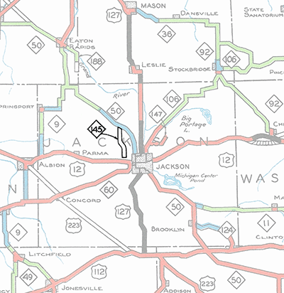 In August 1931, the State Highway Dept established a 4.808-mile trunkline on the northwest side of the Jackson area along modern-day Airport, Springport and Rives Junction Rds from Wildwood Rd west of downtown northerly to M-50 northwest of the city. It was to have been the first segment in an ultimate westerly and southerly bypass of Jackson which never came to be. However, while some progress was made on beginning the first phase of the route in the early 1930s, no evidence exists that M-145 was ever signed in the field and it never appeared on any publicly-distributed State Highway Dept maps. After the initial work stalled, no further progress was made on the route of M-145 and the remainder of the originally-proposed bypass route south of US-12 then curving to the southeast and east to a junction with M-50 at Meridian Rd was never officially established as a state trunkline. The coming of the freeways in the 1950s signaled an end fo the western and southern bypass route around Jackson and in 1956, the entirety of M-145 was cancelled as a state trunkline route. In August 1931, the State Highway Dept established a 4.808-mile trunkline on the northwest side of the Jackson area along modern-day Airport, Springport and Rives Junction Rds from Wildwood Rd west of downtown northerly to M-50 northwest of the city. It was to have been the first segment in an ultimate westerly and southerly bypass of Jackson which never came to be. However, while some progress was made on beginning the first phase of the route in the early 1930s, no evidence exists that M-145 was ever signed in the field and it never appeared on any publicly-distributed State Highway Dept maps. After the initial work stalled, no further progress was made on the route of M-145 and the remainder of the originally-proposed bypass route south of US-12 then curving to the southeast and east to a junction with M-50 at Meridian Rd was never officially established as a state trunkline. The coming of the freeways in the 1950s signaled an end fo the western and southern bypass route around Jackson and in 1956, the entirety of M-145 was cancelled as a state trunkline route. |
| |
For a short time in the mid-1940s, a proposed realignment for US-127 was included on internal Michigan State Highway Dept maps beginning at the existing route northwest of Mason in central Ingham Co on the Alaiedon/Vevay Twp line and curvng due southerly to follow the Tuttle–Blackmore Rds corridor (one mile to the west of much of the existing route between Mason and Leslie) into Jackson Co. In Jackson Co, the route would follow a newly-built highway across the Grand River into Rives Junction, then continue southerly via Rives Junction Rd to M-50 where it would, in theory, follow the already established (but not signed) route of M-145 around the west side of Jackson to Horton Rd where it would resume its southerly course along its existing route. If the entire M-145 bypass route had been constructed as originally proposed as well as this US-127 realignment from Mason southerly, it is likely the M-145 designation would have been decommissioned and M-50 routed along the portion of the route between the M-50 junctions and US-127 routed along the portion from Horton Rd southwest of Jackson northerly toward Mason. This proposed route for US-127 is missing from the internal State Highway Dept maps by 1948, however, and does not seem to be under consideration as a potential route after this point. |
| History: |
1930 (Apr 11) – The State Administrative Board approves the creation of a state trunkline northwest of Jackson consiting of the first segment of a longer westerly and southerly bypass of the city, although it would be more than a year before the trunkline is actually established by the State Highway Dept. |
| |
1931 (Aug 20) – A 4.808-mile state trunkline route is established beginning at Wildwood Ave west of Jackson and running northerly along Airport Rd, then northwesterly via Springport Rd and northerly again on Rives Junction Rd to a terminus at M-50/Clinton Rd northwest of Jackson. While the highway is not signed as M-145, internal State Highway Dept maps show a proposed route for M-145 continuing southerly from Wildwood Ave, crossing US-12/Michigan Ave and proceeding southerly to M-60/Spring Arbor Rd where it turns southeasterly crossing US-127/Horton Rd then bending east-southeasterly to pass north of the Vandercook Lake area, meeting M-50 again at Meridian Rd southeast of Jackson, although this segment is not yet established as a trunkline route. (See 1953 Map.) |
| |
1932 – During the 1932 construction season, initial work on the first phase of the route of M-145 from Wildwood Ave northerly to M-50/Clinton Rd is completed, consiting mostly of "grading and drainage structures." This means basic earthmoving and general grading of the roadway is completed and any culverts, bridges and other such drainage structures are put in place as well. The only segment of the route shown on internal State Highway Dept maps as being "improved" is the 0.9 mile stretch of Springport Rd from Airport Rd–County Farm Rd northwesterly to Rives Junction Rd. That portion is indicated to have a nine-foot wide surface of "two-course gravel, stone or waterbound macadam"—essentially an extremely narrow gravel road. The remainder of the route is considered as being "not improved" by highway department standards. |
| |
1956 (Mar 26) – After not having been constructed as originally intended as a western and southern bypass of Jackson and with plans for the US-12 "Jackson North Belt" and US-127 "Jackson East Belt" in the works, the State Highway Dept cancels M-145 in its entirety. The M-145 route designation has not been used in the state trunkline system since. |
| Controlled Access: |
No portion of Former M-145 was freeway or expressway, existing largely before modern-day control of access principles are practiced. |
| Photographs: |
|
| Weblinks: |
|