

Mackinaw Scenic Shortway
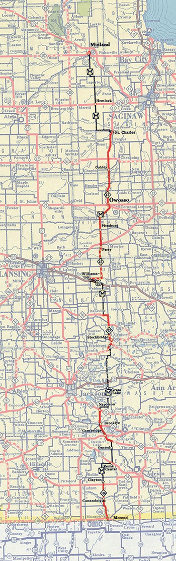
 The Mackinaw Scenic Shortway was a short-lived route which, in its approximately three-year existence, ran from the Ohio state line at Morenci northerly to US-10 at Midland. It was a unique route in many ways, not the least of which was that it never came within 175 miles of its namesake terminus!
The route, which was conceived of in the late 1930s as a shorter alternative taking tourists from Southern Michigan northerly toward the resort and vacation areas in the Straits of Mackinac region, was locally-designated and actually ran along a mixture of state trunklines, county roads and city streets. However, one of the most unique aspects of the Mackinaw Scenic Shortway was that it was a rarity among routes the State Highway Department allowed to be depicted on its state highway map. Even in more modern times, routes such as the Great Lakes Circle Tours, the Michigan Heritage Routes and Michigan Byways—all shown on the Michigan Transportation Map—are all technically special state trunkline route designations assigned and posted by the Michigan Dept of Transportation. Not the Mackinaw Scenic Shortway, however, as it was designated and signed by a private booster organization made up of local business owners and civic leaders. (See map.)
 Like many other similar routes over the years, the Mackinaw Scenic Shortway got its start as the project of an association of business owners and other interested individuals along a route which not only did not have one, cohesive route designation, but was largely served by secondary state trunkline routes, in piecemeal fashion. On June 22, 1939, members of the Mackinaw Scenic Short-Way Association, the Straight-to-the-Straits Association and the Ogemaw County Tourist & Sportsmen's Association all met in Rose City in northern Ogemaw Co to pursue the designation of a route "between US-27 and US-23" that would funnel vacationers and tourists north through the Lower Peninsula toward the Straits of Mackinac. The groups knew efforts of build a Straits Bridge were gaining traction and felt that "present highways will be utterly unable to accommodate north-and-south traffic through this region," according to T.F. Marston of the East Michigan Tourist Association. Deputy State Highway Commissioner G. Donald Kennedy (who would become State Highway Commissioner in 18 months) agreed with this assessment and noted the Shortway route would be "placed on the [Department's] future program" for road improvements, assumedly as a new, connected trunkline route.
The stated goal of the backers of the Shortway were to first create and sign the route to help promote tourism and economic benefit for their communities and, second, to convince state officials of the need to designate the route as a new state trunkline highway. Less than six weeks after the June 1939 meeting in Rose City, State Highway Commissioner Murray D. Van Wagoner stated on August 3 the Mackinaw Scenic Shortway would be added to the next edition of the official state highway map. Its initial Morenci-to-Midland route appeared on the December 1, 1939 (Winter 1939–40) edition of the map with a simplified rendering of the route signs which were placed by the Mackinaw Scenic Short-Way Association along the route that fall. While the route only extended as far north as US-10 at Midland, Van Wagoner suggested any northerly extension at least temporarily use M-30 to the West Branch area where it could pick up existing M-33 to Onaway, then run along US-23 to Cheboygan and the Straits.
By June 1941, the Association noted it had erected more than 400 signs since 1939 along the route and wanted to extend the route from Midland northerly toward the Straits of Mackinac, using the existing route of M-33 and a southerly extension thereof. The group also requested now-State Highway Commissioner Kennedy have the state officially take over the Shortway route and designate it as a state trunkline route with a single, common route designation. Kennedy stated his engineers at the Department would study a northern extension of the route, but that it would be impossible at that time to take over the county roads which were not under state jurisdiction. Most of the state highway budget was required to be spent on main routes targeted by the War Department as "military access routes" as preparations for entering World War II loomed on the horizon.
But, alas, six months later the U.S. officially entered the war with the bombing of Pearl Harbor. With all focus and resources aimed at supporting the war effort, unnecessary and pleasure travel was sharply curtailed, as was any further planning on the Mackinaw Scenic Shortway. The route was last depicted on the Summer 1942 official road map and, when the State Highway Department had Rand McNally & Co redraw the official map for the 1945 edition, the Shortway was left off. No more mention of the route was made in the media during or after the War and it's unclear how long the existing route markers remained before being removed.
Ultimately, the Mackinaw Scenic Short-Way Association was partially successful in getting part of its route included on the state trunkline system. Originally, M-52 ran only from the Ohio state line northerly to US-112 at Clinton, while M-92 ran from US-12 at Chelsea to M-36 north of Stockbridge and M-47 linked US-16 at Williamston with US-10 at Saginaw. Three decades would pass, but eventually M-52 would be extended northerly and take over the M-92 route before being extended again to the Webberville area and then replace M-47 from there to M-46 west of Saginaw. And while M-33 was finally extended from M-55 in Ogemaw Co southerly to M-76 at Alger in Arenac Co, linking M-33 and M-47 via a new trunkline route was proposed in the 1960s and ‘70s, but never came to fruition.
 Like the similarly designated Green Arrow Route along M-66 from Sturgis northerly through Battle Creek, Ionia and Kalkaska, then via US-131 into Petoskey from the early 1960s, the arrival of the state's freeway system from the late 1950s through the ‘60s and ‘70s greatly shifted long-haul traffic patterns. While most highways prior to the mid-1950s were all largely two-lane, uncontrolled access routes all with the same speed limit, once more of the high-speed freeway network was complete, the "in-between" routes like the Mackinaw Scenic Shortway and Green Arrow Route became secondary highways relegated more to serving regional and local traffic needs.
In the end, the Mackinaw Scenic Shortway remains one of the only—if not the only—non-State-designated route to ever be depicted on the official state highway map. The precise reasons why this occurred have never been made known.
Additional Information
- There is very little information on the Mackinaw Scenic Shortway avaialble, either online or in print. One of the only modern sources is LeRoy Barnett's A Drive Down Memory Lane: The Named State and Federal Highways of Michigan published in 2004 by Priscilla Press and, unfortunately, out of print but often available via online booksellers and at used bookshops around the Great Lakes.
- Route Listings, in order south-to-north, associated with the Mackinaw Scenic Shortway:
- Mackinaw Scenic Shortway map, 1939