M-7 is a former state trunkline route existing from May 15, 1927 to May 25–26, 1940*.
|
| Western Terminus*: |
Jct US-131 & M-60 at the cnr of Main St & Michigan Ave in downtown Three Rivers |
| Eastern Terminus*: |
US-112/Chicago Rd (present-day US-12) approximately 2¼ miles west of downtown Coldwater in central Branch Co |
| Final Length*: |
38.986 miles* |
| Maps: |
 Route Map of Former M-7 Route Map of Former M-7
Colon Area State Trunklines map |
| Notes: |
* The termini and final length for M-7 reflect the beginning and ending of the route and its length as of the time of the route's decommissioning in 1940. |
| |
 M-7 is a former state trunkline route which had one iteration from May 1927 until May 1940 when it was redesignated as M-86 in its entirety. This route connected Three Rivers on the west with Centreville (the St Joseph Co seat), and Colon with Coldwater (the Branch Co seat). M-7 began as a (presumably unsigned) five-mile long spur route of M-13, the predecessor designation for today's US-131, connecting Centreville with Three Rivers. With the re-numbering of M-13 to US-131 in 1927, the Three Rivers-Centreville highway was assigned the M-7 designation. The route was extended easterly in the early 1930s and then completely renumbered a decade later, purportedly to reserve the single-digit route designations for an anticipated system of "superhighways" to be built around the state. This effort was stopped in its tracks by World War II and then, after the war, the coming of the Interstate Highway System rendered the need to reserve those designations for a system of freeways moot. While several single-digit route designations have since been re-used since the 1970s, largely in the Metro Detroit area, the M-7 designation has remained unused since 1940. M-7 is a former state trunkline route which had one iteration from May 1927 until May 1940 when it was redesignated as M-86 in its entirety. This route connected Three Rivers on the west with Centreville (the St Joseph Co seat), and Colon with Coldwater (the Branch Co seat). M-7 began as a (presumably unsigned) five-mile long spur route of M-13, the predecessor designation for today's US-131, connecting Centreville with Three Rivers. With the re-numbering of M-13 to US-131 in 1927, the Three Rivers-Centreville highway was assigned the M-7 designation. The route was extended easterly in the early 1930s and then completely renumbered a decade later, purportedly to reserve the single-digit route designations for an anticipated system of "superhighways" to be built around the state. This effort was stopped in its tracks by World War II and then, after the war, the coming of the Interstate Highway System rendered the need to reserve those designations for a system of freeways moot. While several single-digit route designations have since been re-used since the 1970s, largely in the Metro Detroit area, the M-7 designation has remained unused since 1940. |
| History: |
1923 (July 7) – While the M-7 route designation would not officially exist for almost four years, the first segment of what would eventually become M-7 is established as a state trunkline route in central St Joseph Co. As this is prior to the debut of the U.S. Highway System, the main north-south trunkline in St Joseph Co is M-13, running from the Indiana state line northerly generally along the present-day US-131 corridor through Three Rivers, Kalamazoo and on to Grand Rapids, Cadillac and Petoskey. Also during this time, M-13 ran between Constantine and Three Rivers on the east side of the St Joseph River via Featherstone Rd and Lutz Rd, entering Three Rivers from the south along Main St. A 5.0-mile long trunkline spur from M-13/Lutz Rd easterly along present-day M-86 into downtown Centreville is established as a state trunkline route and is officially a designated as part of the overall route of M-13, albeit a spur. In the early 1920s, various spur routes and, in some places, three-legged trunkline routes sharing the same designation are not uncommon. Whether the Three Rivers-Centreville spur is physically signed as part of M-13 or not remains unknown at present. |
| |
1927 (May 15) – The debut of the U.S. Highway System, originally formulated during 1925–26 but finally now signed in the field, necessitates numerous changes in state highway route designations across Michigan. The route formerly known as M-13 becomes part of the new US-131 route, for the most part (from Fife Lake northerly, it is initially designated M-131 for approximately a decade).The old practice of multi-legged trunkline routes (whether signed or unsigned) goes by the wayside at the same time, so the Three Rivers-Centreville "M-13 spur" is assigned the M-7 route designation. Interestingly, from the time when the state trunklines were first given designations (1913) as well as from when they were first signed with route markers in the field (1920), there were no single-digit route designations (1–9). |
| |
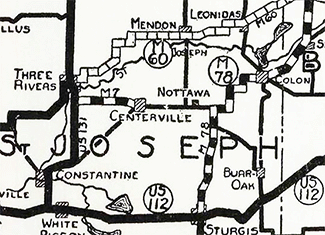
1930 (Dec 2) – An easterly extension of the route of M-7 from Centreville through Colon and onward into Branch Co toward Coldwater is accomplished in thee distinct segments:
- First, a 6.0-mile route from Centrevile northerly from Main St one block to Market St, then easterly out of town, continuing via Truckenmiller Rd to Nottawa Rd ½ mile north of Nottawa, then continues due easterly along a yet-to-be-constructed roadway from Nottawa Rd to M-78 (present-day M-66), about two miles east-northeast of Nottawa. Since a portion of this route is not yet built, M-7 is signed as a "marked-and-maintained" route along present-day M-86 easterly from Centreville via Nottawa to M-78 (present-day M-66) two miles east of Nottawa.
- Then, M-7 is concurrently designated with M-78, itself following another "marked-and-maintained" route (which has not yet been officially established as a trunkline route but is signed and maintained as one temporarily) northerly from the eastern end of the previous segment along M-78 for one mile, then easterly on Marvin Rd for a mile, northerly via Lepley Rd for ½ mile, easterly again on Mountain Rd for a 1¼ mile, then northerly for a mile via Fairfax Rd to Fairfax where both routes turn easterly to run into Colon via South St and Blackstone Ave into downtown.
- The established trunkline route picks back up from downtown Colon. M-7 continues easterly with M-78 on State St for ½ mile (M-78 splits off to head toward Sherwood and Battle Creek via Dallas St), then continues for a total of 14.5 miles via Colon Rd (present-day M-86) into Branch Co to a new eastern terminus at US-112/Chicago Rd (present-day US-12) just west of Coldwater.
See the Colon Area State Trunklines map to help make sense of the routes in the area, especially the "marked-and-maintained" route west of Colon.
|
| |
1933 (May 26) – Two new trunkline establishments in eastern St Joseph Co directly relate to the route of M-7:
- A 6.1-mile long route for M-78 from the south jct with M-7 (two miles east of Nottawa), then due northerly along the township line to M-60 (two miles east of downtown Mendon) is officially established as the state trunkline route, although much of this route has yet to be constructed.
- Simultaneously, a 4.4-mile route for M-7 from M-78 easterly into Colon is established, starting at the newly-established route of M-78 (present-day M-66) just south of the Michigan Central (later New York Central and Penn Central) R.R. and running easterly to the existing signed route at Fairfax, then easterly from Fairfax along the marked-and-maintained route into downtown Colon. The new alignment portion of this route from proposed M-78 northeasterly to Fairfax is also not yet constructed, so traffic remains along the currently-signed route (Marvin, Lepley, Mountain, and Fairfax Rds).
In the end, approximately 3.35 miles of this newly-established route for M-7, from Marvin Rd northerly (with M-78), then east-northeasterly along the Michigan Central line to Fairfax, is unconstructed. See the Colon Area State Trunklines map to help make sense of the routes in the area, especially the "marked-and-maintained" route west of Colon. |
| |
1933 (May 26) – After nearly four full years of the officially-established route from Centreville easterly to M-78 (present-day M-66) running along a different, and not yet fully-constructed, route than the signed route through Nottawa, the segment established in late 1930 via Truckenmiller Rd is cancelled as a state trunkline route, while the 6.4-mile long signed route through Nottawa to M-78 becomes the established route. |
| |
1935 (Oct 22) – After nearly four full years of the officially-established route from Centreville easterly to M-78 (present-day M-66) running along a different, and not yet fully-constructed, route than the signed route through Nottawa, the segment established in late 1930 via Truckenmiller Rd is cancelled as a state trunkline route, while the 6.4-mile long signed route through Nottawa to M-78 becomes the established route. |
| |
1936 (Dec 9) – A new alignment for US-131 between Constantine and Three Rivers on the west side of the St Joseph River is completed and opened to traffic and the northernmost 1.4 mile section of the former route between those cities, from M-7 northerly via S Main St to jct US-131 & M-60 in downtown Three Rivers, becomes an extension to the route of M-7. (The remainder of the former route of US-131 south to Constantine via Featherstone, Centreville-Constantine and Lutz Rds remains an unsigned state trunkline route for now. |
| |
1937 (Aug 30) – The 7.2-mile long section of the former route of US-131 between Constantine and M-7 just south of Three Rivers is cancelled and turned back to local control, while the northernmost 1.4-mile segment, as noted above, retains the M-7 route designation. |
| |
1940 (May 25–26) – The Michigan State Highway Dept makes the decision to withdraw all single-digit route designations, reserving them for a future system of superhighways which were anticipated to be built over the next few decades. (Single-digit route designations were never used for the proposed superhighway system and would reappear in the state in the 1970s.) One of these single-digit highways—M-7 from US-131 at Three Rivers to US-112 just west of Coldwater—is redesignated as M-86, bringing about the third iteraiton of that route. The MSHD crews spend the weekend of May 25–26 replacing all M-7 route markers with M-86 signs along the route. This marks the end of the only iteration of the M-7 route designation on the state trunkline system. (See the M-86 Route Listing for a continuation of the history of this route.) |
| Controlled Access: |
No portion of former M-7 upon decommissioning existed as freeway or expressway, existing largely before modern-day control of access principles are practiced. |
| Photographs: |
|
| Weblinks: |
|
| |
|