

Colon Area State Trunklines
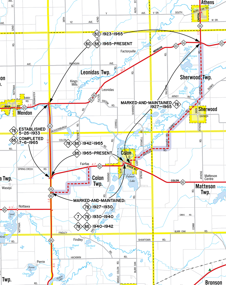
 The map below shows the state trunkline highways in and around the Colon area of eastern St Joseph and western Branch Counties, specifically the varying routes taken by M-78 and its replacement M-66 since the early 1920s. When M-78 was extended southerly from Battle Creek to the Indiana state line near Sturgis in the late 1920s, a segment of the route leading southerly toward Sturgis from M-60 did not physically exist in its entirety. Specifically, the section running along the Leonidas/Mendon and Colon/Nottawa township lines was established as a state trunkline route in May 1933, but for one reason or another, was not constructed and opened to traffic until July 1965! So, from 1927 until 1965, the the section of M-78 from M-60 south of Athens southerly through Sherwood to M-86 at Colon utilized a "marked-and-maintained route," where the highway is not officially established as a state trunkline and technically remains a county road or municipal street, but is "marked" with state highway signage and "maintained" as a state highway. Generally, this is a temporary arrangment where the permanently-established is not yet complete or will not be for a few years. In this case, it would exist for nearly four decades.
Interestingly, by the time the permanent M-78 route was completed, all of that route south of the Greater Battle Creek area was being re-designated as a southerly extension of M-66. Formerly a Battle Creek-to-Charlevoix route, with the new highway segment in St Joseph Co it now runs from the Indiana state line to Charlevoix—the entire length of the Lower Peninsula. So, while the 4½-mile portion of M-78 from M-86 northerly to M-60 was originally established as part of M-78 im 1933, it was actually signed as part of M-66 when it opened in 1965.
Since this represents a non-standard situation over a long period of time and involves several state trunkline routes, the map on this page was created to aid in the understanding of the current and former highway routes in this region. Please see the specific route listings linked below the map.
Back to: