

M-37: Hastings–Battle Creek Expressway
Site contributor Brian Reynolds sent in a gem of a map and information about a proposed expressway-freeway plan which never came to fruition. Much of the M-37 corridor from Hastings through Grand Rapids to Casnovia was upgraded to modern highway design and geometrics in the 1940s and 50s. South of Hastings, however, M-37 and parallel route M-43 remained on their original alignments from early in the century. In the 1960s, the State Highway Department proposed replacing these two substandard highways with a new expressway-freeway alignment, detailed by Brian below. Alas, it was not to be...
The information below is derived, nearly word-for-word, from Brian's report on this proposed highway. Many thanks to Brian for the contribution and permission to reprint it here. A detailed map of the never-built expressway-freeway is also available.
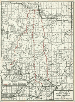 The
map [at right] is from Engineering Report 1718, Supplement B, approved
by State Highway Director Henrik E. Safseth, signature dated July 29, 1968.
The report proposed a right-of-way width to accommodate a fully-controlled
freeway, with only the southbound lanes to be constructed initially. Some
of the cross-roads would have been closed initially, some would have been
at-grade crossings. If built, the early version would have looked much
like M-37 between Sparta
and Casnovia. Of the 22.4 miles of new highway proposed, only about 3½
miles were actually built.
The
map [at right] is from Engineering Report 1718, Supplement B, approved
by State Highway Director Henrik E. Safseth, signature dated July 29, 1968.
The report proposed a right-of-way width to accommodate a fully-controlled
freeway, with only the southbound lanes to be constructed initially. Some
of the cross-roads would have been closed initially, some would have been
at-grade crossings. If built, the early version would have looked much
like M-37 between Sparta
and Casnovia. Of the 22.4 miles of new highway proposed, only about 3½
miles were actually built.
At the extreme north end, about 1½ miles of M-37/M-43 from
the current junction in the center of Hastings west to Heath Road was constructed
in the very early '70s. This replaced the Green Street routing west of Broadway
in Hastings, a mostly residential street not well suited to a busy duplexed
trunkline.
At the extreme south end, about 2 miles of the proposed road became M-96 (Dickman
Road) through Fort Custer, from about the Calhoun-Kalamazoo county line east
to its terminus at Business
Loop I-94. This section is well described in the M-96
listing.
Apparently both upgrades were done on their own merits, and not in the context
of the 1968 proposal. However, the relocation west of Hastings included what
would have been the freeway interchange. Enough limited access right of way
was acquired to have the east-west trunkline be a fully divided boulevard through
the freeway interchange. Only the (proposed) westbound lanes were actually
built. It was only in the early-to-mid 1990s that MDOT finally concluded the freeway
interchange would never happen. The "excess right-of-way" (for the
eastbound lanes) was sold to Rutland Charter Township for pennies. They get
offers of huge dollars every year, and thus far have declined all of them.
The Walmart store had to buy the access rights from MDOT to breach the previous
limited access line for their driveway.