

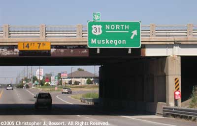
US-31 Freeway in Ottawa County
Jump to: History • A Changing of the Guard, A Change in Direction • Fast-Forward to the 1990s • A Solution is Chosen • Postponement • Work Begins • M-231 Opens & Future Plans • Additional Information
History
 In the years following the end of World War II, with traffic volumes on
Michigan's highways skyrocketing and the Baby Boom in full swing, it became
painfully aware to the Michigan State Highway Department that the existing
two- and three-lane highways connecting the major cities and travel destinations
around the state were woefully inadequate. The department, already trying
to catch up on years of deferred maintenance during the war, had actually
begun planning for the post-war travel boom in 1943 when it issued a major
state trunkline development map.
In the years following the end of World War II, with traffic volumes on
Michigan's highways skyrocketing and the Baby Boom in full swing, it became
painfully aware to the Michigan State Highway Department that the existing
two- and three-lane highways connecting the major cities and travel destinations
around the state were woefully inadequate. The department, already trying
to catch up on years of deferred maintenance during the war, had actually
begun planning for the post-war travel boom in 1943 when it issued a major
state trunkline development map.
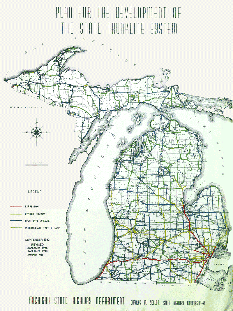 This
document and its associated plans were updated in 1946, 1948 and again
in 1951 and called for the
construction of "expressways," or freeways in modern day terms,
along today's I-94 corridor
from Indiana to Mount Clemens, along the I-75 corridor
from Toledo to Bay City and following today's I-96 from
Detroit to Brighton. All other major upgrades were to only consist of four-lane
divided highways, likely with little or no control of access. In the case
of US-31, the State
Highway Department had earmarked the entire route from the Indiana state
line northerly to US-10 at
Ludington for such four-lane divided upgrades, which likely included bypasses
of the larger communities along the way. At the time, the plan was ambitious
and seemed to address the current and anticipated traffic needs well into
the future.
This
document and its associated plans were updated in 1946, 1948 and again
in 1951 and called for the
construction of "expressways," or freeways in modern day terms,
along today's I-94 corridor
from Indiana to Mount Clemens, along the I-75 corridor
from Toledo to Bay City and following today's I-96 from
Detroit to Brighton. All other major upgrades were to only consist of four-lane
divided highways, likely with little or no control of access. In the case
of US-31, the State
Highway Department had earmarked the entire route from the Indiana state
line northerly to US-10 at
Ludington for such four-lane divided upgrades, which likely included bypasses
of the larger communities along the way. At the time, the plan was ambitious
and seemed to address the current and anticipated traffic needs well into
the future.
To implement this plan, the department under State Highway Commissioner Charles M. Ziegler began to improve the segments most in need of upgrades and realignments first. For US-31, the portion of the route from Holland northerly to Grand Haven was near the top of the list. Work began on the first of three "phases" of the Holland-Grand Haven upgrades in 1948 and the relocated US-31 opened to traffic from M-21/Chicago Dr on the east side of Holland northerly to West Olive in 1950, replacing the former, narrow two-lane route on N River Ave, 136th Ave and West Olive Rd. At the time, the new highway was only a two-lane road, but built to high standards on a right-of-way to accommodate an additional two lanes and a narrow grassy median strip.
The second "phase" of the planned upgrades was underway by 1953. This segment of the improved US-31 would begin at the southern end of the 1950 route at M-21/Chicago Dr east of Holland and continue southerly before swinging southwesterly and merging back into the existing route of US-31 along Washington Ave/Blue Star Hwy south of Holland. This is the so-called "Holland Bypass." When the bypass opened in 1955, it was a four-lane facility with control of access so that motorists could only enter or leave the highway at designated at-grade intersections. The former route of US-31 through downtown Holland was then redesignated as BUS US-31 at that time.
Simultaneous to the construction and completion of the "Holland Bypass," the State Highway Department also added a second carriageway alongside the existing two lanes of US-31 from West Olive northerly for 6.3 miles to the Ferris St intersection south of Grand Haven. While not controlled- or limited-access, the additional travel lanes and separation of traffic with a median was part of the overall upgrade plans, aiming at making US-31 a four-lane, mostly-divided highway from Niles to Ludington.
Two years later in 1957, the third "phase" of the Holland-to-Grand Haven improvements was completed when the relocated US-31 opened to traffic from Ferris St in Grand Haven Twp northwesterly to Robbins Rd at the Grand Haven city limit, then northerly through the city along the newly constructed Beacon Blvd to Jackson Ave. From Ferris to Robbins, the new highway was a four-lane divided, limited-access facility with access only at select intersections, while Beacon Blvd within the city was simply a four-lane boulevard with no control of access. The final stretch of two-lane US-31 from south of Holland to Grand Haven would be "twinned" next, however a retirement and an election at the state level would change Michigan highway plans in a major way.
A Changing of the Guard, A Change in Direction
 Charles M. Ziegler had been Michigan's State Highway Commissioner since
1943, which in those times was an elected post. It was no coincidence that
the state trunkline development map noted above was released in 1943 and
updated several times while Ziegler was at the helm of the department.
He retired and an election on April 1, 1957 brought
John C. Mackie into the commissioner's office. Immediately, Michigan's state
trunkline upgrade plans were scrapped and the whole system was re-thought
from the ground up. Ziegler had only envisioned a select few "expressways" in
the state, with the remainder of the major routes being upgraded only to
four-lane divided highways. While the Interstate Highway Act of 1956 a
year earlier had earmarked additional freeway mileage for the state, Mackie
decided many of the routes connecting major cities and recreational areas
to be constructed to freeway standards instead of merely four-lane divided
highways. It was at this time many of Michigan's non-Interstate freeway
corridors were conceived.
Charles M. Ziegler had been Michigan's State Highway Commissioner since
1943, which in those times was an elected post. It was no coincidence that
the state trunkline development map noted above was released in 1943 and
updated several times while Ziegler was at the helm of the department.
He retired and an election on April 1, 1957 brought
John C. Mackie into the commissioner's office. Immediately, Michigan's state
trunkline upgrade plans were scrapped and the whole system was re-thought
from the ground up. Ziegler had only envisioned a select few "expressways" in
the state, with the remainder of the major routes being upgraded only to
four-lane divided highways. While the Interstate Highway Act of 1956 a
year earlier had earmarked additional freeway mileage for the state, Mackie
decided many of the routes connecting major cities and recreational areas
to be constructed to freeway standards instead of merely four-lane divided
highways. It was at this time many of Michigan's non-Interstate freeway
corridors were conceived.
However, Mackie had one big problem: those segments of highway which had just been or were currently being upgraded to four-lane divided facilities (with no control of access) when he took office. For some of these routes, such as US-23 north of Ann Arbor and US-127 from Jackson to Mason, State Highway Department engineers set out to design plans to convert these routes to freeways with the addition of grade separations (over- and underpasses), interchange ramps and the removal of all other access points. US-31 from Holland to Grand Haven was not one of these routes, as there was a segment of uncontrolled-access from West Olive northerly to Ferris St in the middle of the other limited-access segments (Washington Ave south of Holland to West Olive and Ferris St northerly to Robbins Rd). The existing plans to add the second set of travel lanes to the two-lane, controlled access section from M-21/Chicago Dr northerly to West Olive were kept on the books, but Mackie and the department decided all upgrades to US-31 from Grand Haven northerly past Muskegon would be to full freeway standards, as would the proposed Interstate from Benton Harbor to Holland and then on toward Grand Rapids. Thus, one can see the genesis of the later debate on how to fill the glaring hole in the freeway route up the western side of the Lower Peninsula.
 As noted above, the two-lane segment of the relocated US-31 built
on four-lane, limited-access right-of-way from M-21/Chicago
Dr at Holland northerly to West Olive completed in 1950 was converted to
a four-lane divided facility with the addition of two extra lanes separated
from the original highway by a narrow median strip in 1958. Now US-31 was
a four-lane, divided highway from south of Holland all the way to the Grand
River bascule (draw) bridge in Grand Haven with a brand-new four-lane freeway
nearing completion from the drawbridge northerly past Muskegon.
As noted above, the two-lane segment of the relocated US-31 built
on four-lane, limited-access right-of-way from M-21/Chicago
Dr at Holland northerly to West Olive completed in 1950 was converted to
a four-lane divided facility with the addition of two extra lanes separated
from the original highway by a narrow median strip in 1958. Now US-31 was
a four-lane, divided highway from south of Holland all the way to the Grand
River bascule (draw) bridge in Grand Haven with a brand-new four-lane freeway
nearing completion from the drawbridge northerly past Muskegon.
Freeway upgrades along the US-31 route leading away from Ottawa Co in both directions were largely completed within the next five years. To the north, the US-31 freeway bypass of Muskegon pushed north from Ferrysburg to US-16 in 1958, was complete to M-46/Apple Ave in 1959 and was extended all the way past Whitehall and Montague by 1964. To the south, the proposed I-96/US-31 freeway from Benton Harbor to Holland was completed in December 1963, although it was opened as I-196/US-31 when the routes of I-96 and I-196 were switched earlier that year. By the mid-1960s, US-31 was built to freeway standards for 45 miles to the south of Holland and for 30 miles to the north of Grand Haven. (By 2003, this mileage has increased to 67 miles north of Grand Haven to Ludington, and south of Holland, 75 of the 77 miles of US-31 to the Indiana state line are currently freeway grade with the last two miles proposed for completion in the future.)
In an ironic twist, State Highway Commissioner Ziegler, trying to be proactive about solving many of the state's worst traffic and highway capacity issues, actually caused major ones decades later. Because the highway department had just finished upgrading all of US-31 from south of Holland to Grand Haven to a four-lane divided highway, much of it on new alignment, the state could not justify bypassing this section a few short years later with a brand new and expensive freeway alignment, especially since it was not on the newly-created Interstate Highway System. That reason alone was how the similarly-upgraded M-21 route (now M-121) along Chicago Dr from Holland to Grand Rapids was bypassed by the freeway (I-196) in the early 1970s, although that was the last portion of that highway to be completed, also as a result of Ziegler's upgrades. Thus, US-31 through Ottawa Co became a 24-mile divided highway segment sandwiched between freeway segments totaling over 140 miles.
Fast-Forward to the 1990s
In the ensuing forty years, not only did the cities along the US-31 corridor continue to grow and expand, traffic volumes up and down the west coast of the state continued to grow as well. Not only were there more cars using the highway which, in turn, began causing greater amounts of congestion, especially during the summer tourist season, but incidents of accidents increased and the bascule (draw) bridge over the Grand River at Grand Haven and Ferrsyburg also emerged as major choke point in the system. So much had the situation degraded that according to MDOT documents, in 1990 the department "prepared a preliminary assessment of conditions within the study area. This report recommended further study of several alternatives for the existing US-31 alignment, and identified the possibility of an alternate by-pass alignment to relieve traffic congestion on existing US-31." At this point, MDOT was beginning the process which would address the non-freeway gap across Ottawa Co.
 In support documentation prepared for the project, MDOT outlined
many of the reasons they felt a major upgrade to US-31 through
Ottawa Co was needed. Not only was the route a principal arterial on the National
Highway System and a route in the state's "Priority Commercial
Network" of highways, it was a major tourist access route to the beaches,
cities and other recreational opportunities of the state's Lake Michigan
coastal region all the way up to the Mackinac Bridge near the northern
terminus of US-31.
In addition, traffic volumes on the route were steadily rising. Average
daily traffic volumes in 1997 ranged from 11,500 to 50,000 in Holland,
from 21,000 to 24,000 in the rural area north of there and from 28,000
to 58,500 in Grand Haven. (To contrast, the average daily traffic
volume over the Grand Haven bascule bridge in 2004 was 65,500, well above
the high levels reported in 1997!) Also, MDOT figures
on crash data for US-31 showed that that "the accident rates in various
urban segments of US-31 (i.e., Holland and Grand Haven) were more than
double the average rates for comparable facilities in the Grand Region
and in the entire state." Nearly half of all the accidents from Holland
to Ferrysburg occurred within Grand Haven itself.
In support documentation prepared for the project, MDOT outlined
many of the reasons they felt a major upgrade to US-31 through
Ottawa Co was needed. Not only was the route a principal arterial on the National
Highway System and a route in the state's "Priority Commercial
Network" of highways, it was a major tourist access route to the beaches,
cities and other recreational opportunities of the state's Lake Michigan
coastal region all the way up to the Mackinac Bridge near the northern
terminus of US-31.
In addition, traffic volumes on the route were steadily rising. Average
daily traffic volumes in 1997 ranged from 11,500 to 50,000 in Holland,
from 21,000 to 24,000 in the rural area north of there and from 28,000
to 58,500 in Grand Haven. (To contrast, the average daily traffic
volume over the Grand Haven bascule bridge in 2004 was 65,500, well above
the high levels reported in 1997!) Also, MDOT figures
on crash data for US-31 showed that that "the accident rates in various
urban segments of US-31 (i.e., Holland and Grand Haven) were more than
double the average rates for comparable facilities in the Grand Region
and in the entire state." Nearly half of all the accidents from Holland
to Ferrysburg occurred within Grand Haven itself.
Even beyond those factors, it was also noted the US-31 bascule (draw) bridge spanning the Grand River at Grand Haven and Ferrysburg (completed 1959) was the only such crossing of the river between Lake Michigan and the 68th Ave bridge in Eastmanville, a distance of 20 miles, and only one of three Grand River crossings on that river's 34-mile journey through Ottawa County. Adding to that were problems with the mechanical and electrical workings of the bascule bridge resulting in improper closures and being stuck in the open position, sometimes for hours at a time. The resulting massive traffic jams, public safety headaches and negative impacts on the tourism and other industries in the area have all pointed toward the need to look at major improvements in the corridor.
After MDOT's preliminary assessment in 1990, a US-31 Location Design Study was initiated in 1993 and a year later, according to MDOT, "the environmental portion of the project required for the Draft Environmental Impact Statement (DEIS) was initiated." An engineering firm was brought on board in 1993 as well to begin the long, arduous process of first defining then narrowing down the list of proposed alternatives. In early 1994, a list of 15 corridors, ranging from ones incorporating the existing route of US-31 between Holland and Grand Haven to ones occupying parallel routes along 120th and 84th Aves were announced, igniting the usual firestorms from affected citizens residing within each of the 15 proposed corridors. By early December of that same year, 11 of the 15 corridors had been removed from consideration, including all of those running along 84th Ave in central Ottawa Co. The northern and eastern bypass of Zeeland, however, was re-added to the list of possible routes later on.
A Solution is Chosen
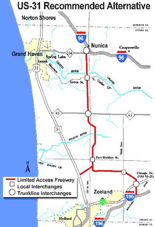
After two public hearings in 1998, MDOT announced the location of the preferred alternative for a US-31 freeway bypass through Ottawa Co on June 21, 1998, utilizing the Zeeland bypass and 120th Ave corridor routes northerly to Nunica. The freeway would begin at an interchange with I-196 east of Zeeland in the neighborhood of 72nd Ave and proceed northerly for a short distance before turning northwesterly across 84th Ave, then westerly paralleling Port Sheldon Rd to the south as it approached 120th Ave. An additional spur route connecting the existing route of US-31 with the new freeway would diverge from US-31 somewhere north of New Holland St and run northeasterly to meet up with the new bypass at 120th Ave south of Port Sheldon St where the mainline bypass would make a 90° turn to the north. From that point, the new freeway would run northerly along the 120th Ave corridor through Olive and Robinson Twps, crossing the Grand River on a new bridge approximately halfway between Grand Haven and Eastmanville, then continue northerly to a new interchange with I-96 and M-104 at Nunica.
 In conjunction with the new freeway alignment, the state also included
major plans for upgrading portions of the existing route of US-31 from
Holland northerly through Grand Haven, including adding through lanes to
the highway through Holland and Grand Haven and eventually replacing the
existing Grand Haven bascule (draw) bridge with a new, higher fixed span
across the Grand River. MDOT has
stated the existing route of US-31 will
remain on the state trunkline system after the new freeway bypass has been
completed. At the time it was announced the cost of entire project was
quoted at approximately $587 million, with about $315 million for the freeway
bypass portion and the remainder for the existing highway improvements.
In conjunction with the new freeway alignment, the state also included
major plans for upgrading portions of the existing route of US-31 from
Holland northerly through Grand Haven, including adding through lanes to
the highway through Holland and Grand Haven and eventually replacing the
existing Grand Haven bascule (draw) bridge with a new, higher fixed span
across the Grand River. MDOT has
stated the existing route of US-31 will
remain on the state trunkline system after the new freeway bypass has been
completed. At the time it was announced the cost of entire project was
quoted at approximately $587 million, with about $315 million for the freeway
bypass portion and the remainder for the existing highway improvements.
While the plans were generally supported by most area citizens as well as by the cities of Holland and Grand Haven, the Ottawa County Board of Commissioners, as well as the Macatawa Area Coordinating Council, the townships of Olive and Robinson opposed the selected route, citing mostly the potential loss of valuable farmland and the uncontrolled urban sprawl the freeway would likely bring. MDOT officials were quoted as saying they attempted to minimize the impact the freeway would have on farmland by only including eight interchanges along the entire route of the bypass, with only three interchanges at non-trunkline routes—North Cedar Dr (to provide local and emergency access to the new Grand River bridge), Port Sheldon Rd and 96th Ave. The other interchanges include trunkline-to-trunkline connections at I-196 at the south end of the freeway, M-121/Chicago Dr, the existing US-31 connector north of New Holland, M-45/Lake Michigan Dr and at M-104 and I-96 in Nunica at the north end. As for controlling sprawl, MDOT leaders noted that was an issue for local governments to address through their local zoning, master planning and ordinances. Opposition groups, however, noted it is difficult to enact proper zoning when development pressures spawned by a new freeway are so great.
To help evaluate the positive and negative impacts each of the five major alternatives—the four MDOT alternatives plus one put forth by a local citizen's opposition group—an independent research group was tapped to study the project. As noted on a website created to disseminate information about the team, the process and their results:
A team of researchers from the Basic Science and Remote Sensing Initiative (BSRSI) at Michigan State University (MSU) conducted a study of future secondary and cumulative impacts of several proposed transportation infrastructure improvements on or near US-31 for a 30 mile area between Holland and Muskegon, Michigan. Serious safety issues and traffic congestion prompted a transportation planning process at the Michigan Department of Transportation. A Draft Environmental Impact Statement (DEIS) prepared for MDOT by URS Corporation documents several possible transportation solutions. The MSU research team examined the future potential land use impacts of several of these alternatives by employing land use forecasting models. The results of the study [were] shared with the public and incorporated into the final EIS [at] a public meeting [on] February 7, 2002.
The results showed that while there were some minor differences between the amount of development, loss of open space and urban sprawl that would likely occur in each township, overall the results were nearly identical across all options studied.
Postponement
In 2003, worsening economic conditions forced newly-elected Governor Jennifer Granholm to postpone the US-31 bypass project, as well as several other large projects around the state, instead focusing the limited state transportation dollars on maintaining existing infrastructure in need of repair rather than building new highways. The project did get a shot-in-the-arm from the $286.5 billion transportation funding bill signed into law on August 10, 2005 by the president which earmarked $7.2 million for improvements to the US-31 corridor between Holland and Grand Haven. MDOT planned to use those dollars to begin planning on the first segment of the freeway—the new Grand River crossing near Nunica—which has been deemed the highest priority portion of the bypass. Underscoring that, MDOT leaders announced on June 27, 2005 that they hoped to begin construction on the bridge and its approaches within five years, beginning with purchasing several properties lying in the flood-prone portion of the river where the new span will be built.
 With the state's economy rebounding more slowly than expected, MDOT announced on March 13, 2006 a revision in the overall bypass plan. Instead of building the entire corridor from north to south, segment after segment, the state altered their plans instead to only construct one of the proposed two Grand River spans in the 120th Ave corridor and completing a two-lane, limited-access highway from I-96 & M-104 near Nunica southerly across the river, ending at M-45/Lake Michigan Dr. This two-lane expressway was constructed on a four-lane freeway right-of-way to accommodate its eventual conversion to a fully controlled-access facility in the future. Also changed was the highway's route designation. Since it would not connect directly with US-31, it was designated M-231 instead—a nod to its originally-intended route number and possible future designation should the remainder of the freeway ever be constructed. M-231 serves as a relief and detour route when the US-31 Grand Haven Drawbridge is stuck in the open position or experiences other mechanical problems.
The new plan also included widening two segments existing US-31 from two to three lanes in each direction. In Holland, a third lane was added from Lakewood Blvd northerly to Quincy St in an area featuring repeated rush hour back-ups and congestion. MDOT had studied extending the third lane southerly to through the BL I-196/Chicago Dr interchange to 8th St, but the expense of having to reconstruct and widen overpasses at Lakewood Blvd, the Black River/CSX Railroad and Chicago Dr was too much. In Grand Haven, the third lane was added between Franklin and Jackson Sts to, again, help alleviate congestion and back-ups that frequently happen in that area.
Work Begins
The M-231 Final Environmental Impact Statement (FEIS) was completed in 2007 and approved along with the Record of Decision by the Federal Highway Administration (FHWA) in 2010. The engineering and design of the new highway and bridge began in 2010 along with the first right-of-way acquisition. The first actual construction on phase one of the M-231 project began in 2011 and includes the new 3,700-foot long Grand River bridge, the roadway itself just to the west of existing 120th Ave, improvements to the I-96 & M-104 interchange (where M-231 terminates on the north), ramps to and from M-231 at I-96, and new ramps at the I-96 & B-31/112th Ave interchange.
The first part of the project completed was an overpass carrying the future M-231 over Cedar Dr in Robinson Twp. Completed in mid-2012, it was originally slated to be done a year earlier until funding was reallocated to other projects. Also in 2012, M-104/Cleveland St was widened and reconstructed from west of 124th Ave to B-31/112th Ave at Nunica, the B-31/112th Ave bridge over I-96 was replaced with a new four-lane structure, the existing ramps at the B-31/112th Ave & I-96 interchange 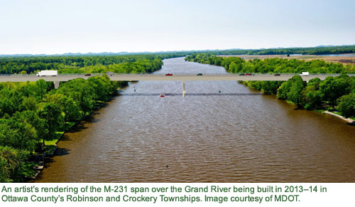 were reconstructed, a new westbound I-96 on-ramp was completed, and the Cleveland St/Apple Dr/112th Ave intersection was reconfigured.
In January 2013, however, crews began building the bridge carrying M-231 over the Grand River and Little Robinson Creek as well as 1.4 miles of the roadway itself. The new M-231 Grand River crossing is the seventh-largest public bridge in Michigan (noting that Michigan has its share of long bridges!), will be 3,700 feet in length and 47 feet high. The Little Robinson Creek bridge is 548 feet long and about 30 feet above the water. Additionally, new ramps from eastbound I-96 to M-231 & M-104 and to I-96 westbound were completed in 2013. This marked the technical completion of the first ¼ mile of M-231 along 120th Ave northerly from M-104/Cleveland St even though it would not be signed as such until the remaining seven miles of the route were completed and opened to traffic southerly to M-45/Lake Michigan Dr.
M-231 Opens & Future Plans
As of 2013, MDOT officials were optimistically looking at the new bridge and remainder of M-231 to be open to traffic "in 2016 or 2017," as long as the project funding held and no unforseen issues arose. After years of delays in the overall project, though, M-231 was completed ahead of that timeline in late 2015, officially 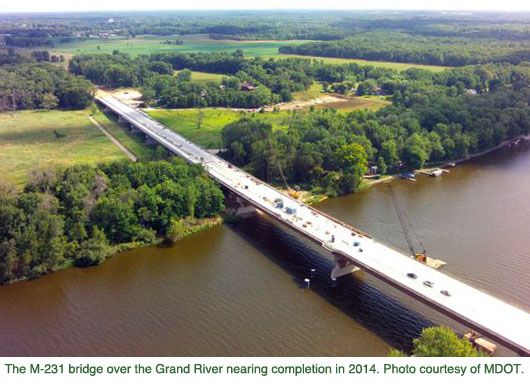 opening to all traffic over its entire route at the end of October. The full project, which also includes impovements to the route of US-31 in Holland and Grand Haven, won't be complete until 2019, however. Costs for the project are pegged from anywhere from $70 million to $200 million, depending on which parts of the overall project are included in the calculations.
Plans to complete the "US-31 Bypass" freeway from M-45/Lake Michigan Dr southerly to I-196 near Zeeland or to convert existing two-lane M-231 into a four-lane facility (freeway or expressway) are currently not in any of the near- or medium-term MDOT project planning documents. As such, it remains unknown if the remainder of the route will be completed as originally planned.
Additional Information
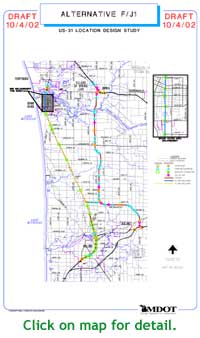
- Map of Proposed US-31 Freeway in Ottawa County – from MDOT.
- US-31 Route Listing
- M-231 Route Listing
- M-231 near Nunica, Ottawa County – archive of MDOT's project page on the M-231 project from I-96 to M-45.
- US-31 Bypass Public Meeting Presentation – a presentation given by MDOT at the September 22, 2010 public meeting for the M-231 project (via archive)
- US-31
Holland to Grand Haven Corridor Study - from MDOT,
giving information on the plans for the US-31 Freeway in Ottawa County.
- Draft Environmental Impact Statement (via archive)
 M-231 archaeology earns Governor's Award for Historic Preservation – a video press release from MDOT, May 2015.
- A sneak peek at M-231 – a time-lapse video from October 2, 2015 driving along M-231 prior to its opening to traffic.
- M-231 Bridge construction site visit – FOX 17 news story video clip from August 2014.
- MSU US-31 Land Use Study Homepage – from MSU (via archive): "A team of researchers from the Basic Science and Remote Sensing Initiative at MSU conducted a study of future secondary and cumulative impacts of several proposed transportation infrastructure improvements on or near US-31 for a 30 mile area between Holland and Muskegon, Michigan."
- Road to Ruin: Grand Haven-Holland Bypass/U.S. Route 31 (via archive) – one of 27 identified road projects opposed by the "Taxpayers for Common Sense," a political watchdog group whose goal is to encourage the government to spend less tax money.