

| Back to Previous Route: M-45 |
 |
On to Next Route: M-47 |
| Western Terminus: | Cnr First St (formerly sbd BUS US-31) & Webster Ave in downtown Muskegon |
| Eastern Terminus: | Port Sanilac at M-25 (cnr Main St & Ridge St) |
| Length: | 199.680 miles |
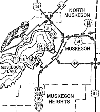
| Maps: | Route Map of M-46 |
| Notes: | This highway, a major connecting route from Muskegon to Saginaw and into the Thumb, is only one of three cross-peninsular state ("M-numbered") highways in the Lower Peninsula today. The others are M-55 (Manistee-to-Tawas City) and M-72 (Empire-to-Harrisville). |
In "State Trunkline Needs, 1960–1980," a set of maps prepared by the State Highway Dept's Office of Planning, Programming Division in 1960 showing possible additions, upgrades and improvements to the state trunkline system over the ensuing twenty years, MSHD staff recommended many changes to the route of M-46 during that timeframe, including:
|
|
| History: | c.1920 – At the outset, M-46 runs approximately along its present-day routing from M-13 (later US-131) at Howard City to downtown Saginaw. The two major differences are: 1) the route runs easterly and northerly in a stair-step fashion from downtown Howard City to Amble; and 2) at the Montcalm/Gratiot Co line, M-46 dips south to run through Riverdale and Elwell into downtown Alma, then northeasterly via Michigan Ave into Saint Louis. |
| 1924 – M-46 is extended both easterly and westerly to end at its present-day termini in Muskegon and Port Sanilac. On the western end, M-46 is extended southerly from Howard City via M-13 (later US-131) to Cedar Springs, then due westerly via 17 Mile Rd to meet M-54 (later M-37) at Kent City, jogging northwesterly into Casnovia, then due westerly replacing all of M-43 to end at M-11 (later US-31) in downtown Muskegon, adding 51 miles to the highway's length. On the eastern end, M-46 is extended easterly from Saginaw, via Richville, Kingston, Sandusky and Carsonville to end in Port Sanilac, adding 68 more miles. | |
| 1926–30 – From 1926 to 1930, US-131/M-46 is realigned onto a new, more direct alignment between Cedar Rapids and Howard City via Sand Lake and Pierson. The former, stair-step route is turned back to local control. | |
| 1934 – The route is realigned between Howard City and Amble to run due westerly from Amble on its present-day alignment along Howard City-Edmore Rd to US-131, then southerly with US-131 to Howard City. The former route is turned back to local control. | |
| 1935 – M-46 appears to have become two discontinuous routes in 1935. Until this time, M-46 east of Muskegon follows its present-day route to and with M-37 to Kent City, then easterly via 17 Mile Rd to Cedar Springs, then northerly along with US-131 to Howard City. On the Official 1935 Michigan State Highway Department map, the portion of M-46 between Kent City and Cedar Springs (17 Mile Rd) is shown as not being a marked trunkline and the two portions of M-46 are not connected with each other. | |
c.1936–37 – Some changes to the route of M-46 occur at this time:
|
|
| 1937 (Dec 17, 29) – The State Highway Dept's Highway Advisory Board authorizes a 6.3-mile long westerly extension for M-46 in Muskegon from downtown to the Coast Guard station on the Lake Michigan shore on December 17. The segment of highway is officially established as a state trunkline on December 29, departing Apple Ave at Jay St travelling southwesterly via Hartford Ave, then westerly via Houston Ave to Second St, continuing southwesterly along Houston St to Glade St, then westerly via Washington Ave to Lakeshore Dr, then along Lakeshore Dr to Beach St to the terminus of Beach St at the lakeshore. The winding 3½-block long, 0.3-mile former segment of M-46 along Apple Ave, Pine St and Myrtle Ave between Jay St–Hartford Ave westerly to US-31/Terrace St is cancelled as a trunkline and turned back to city control. | |
| 1938 – M-46 is realigned onto a more direct route at Six Lakes in north-central Montcalm Co, shaving a mile from the route. The former route is turned back to county control. Also, the concurrent M-46/M-82 designation between Newaygo and Howard City is removed and becomes only M-46. Ironically, this will be redesignated as M-82 when M-46 is rerouted in 1973. | |
| 1947 – A minor realigment is completed at Cedar Lake in northeastern Montcalm Co with the former route turned back to local control. | |
| 1950 (Oct 31) – With the announcement of future plans for the Muskegon area's overall state trunkline network, the State Highway Dept notes the portion of M-46 west of BUS US-31 in downtown Muskegon along the south shore of Muskegon Lake and leading to Pere Marquette Park would be "discontinued" in the future as the department has come to the conclusion that "its use by state trunkline traffic is insignificant and is used essentially as a local arterial thoroughfare connecting with a municipal park." | |
| 1952 (Nov 6) – State Highway Commissioner Charles M Ziegler attends a ribbon-cutting ceremony at the "Four Corners" (jct M-51 NORTH & M-46 west of Carsonville) celebrating the completion of paving of M-46 between Sandusky and Four Corners in Sanilac Co, which news reports also term the completion of paving of the whole of M-46 across the entire state from Lake Michigan at Muskegon to Lake Huron at Port Sanilac as well. The segment of M-46 from M-51 NORTH/Ruth Rd westerly to Sandusky had been paved in 1951 and the portion from Carsonville to Port Sanilac had been paved earlier in 1952. (A short segment of M-46 [present-day M-82] in eastern Newaygo Co near the community of Oak Grove remains unpaved, however, meaning the entire length of M-46 is not yet fully hard-surfaced, in spite of the media accounts.) | |
| 1954 (Jan 18 9:30 am) – With the beginning of construction in Muskegon on the Norton-Glade Expwy (present-day BUS US-31/Seaway Dr) railroad overpass at the location where Houston St turns westerly and becomes Washington Ave, M-46/Houston St–Washington Ave is permanently closed and the route M-46 south of downtown Muskegon is altered to run along a new Marked & Maintained route (not officially transferred to state control, but remaining under city jurisdiction, but with state maintenance) route: From Houston St, M-46 now turns southeasterly via Seventh St for just over one block, then southerly along Park St for three blocks to Southern Ave where M-46 now turns westerly for 1.1 miles along Southern Ave back to its existing alignment at Lakeshore Dr. The former route of M-46 along Houston Ave from Seventh St to its new terminus at the Norton-Glade Expwy construction site and along Washington Ave from the Norton-Glade westerly to Lakeshore Dr and the portion of Lakeshore from Washington to Southern remain as unsigned state trunkline highway segments for the time being. | |
| 1957 (Mar 5, Noon) – A major trunkline realignment in downtown Muskegon comes as a result of the ongoing preparations for the future completion of the Norton-Glade Expressway (present-day Seaway Dr), currently under construction, heading away to the south from downtown. Two parallel city streets—Pine & Springs Sts—are assumed as Marked & Maintained trunkline routes between M-46/Apple Ave and Webster Ave. From Apple Ave, M-46 is now routed northwesterly along the one-way pair of Pine & Spring Sts to the newly-converted one-way pairing of Muskegon & Webster Aves, then southwesterly through downtown via Muskegon & Webster to the northern end of the newly-completed Norton-Glade Expwy (present-day BUS US-31/Seaway Dr), then southerly via the Norton-Glade to the end of the completed expressway at Laketon Ave. M-46 now turns westerly along Laketon Ave, which also becomes a Marked & Maintained trunkline route back to the existing M-46 route at Lakeshore Dr, where it continues toward Pere Marquette Park on Lake Michigan. M-46 markers and state maintenance is ceased along the former Marked & Maintaiend route of M-46 along the Seventh St–Park St–Southern Ave route from the previous three years, while the Hartford Ave–Houston Ave–Washington Ave–Lakeshore Dr route that had been M-46 between Apple Ave and Laketon Ave prior to 1954 remains an unsigned state trunkline route for now. | |
| 1959 (Oct 22, Nov 9) – Another major set of state trunkline realignments marks the opening of the Norton-Glade Expwy (present-day Seaway Dr) from Harvey Rd (present-day US-31 freeway) southeast of Muskegon westerly and northerly into downtown Muskegon. It brings both official establishment/abandonment changes as well as alterations to the Marked & Maintained routes, as in several cases, trunkline routes in downtown Muskegon are utilizing city streets while other routes have had their route markers removed and have been only unsigned trunklines up to this point. The traffic and signage changes take plan on or around November 9, while all the official establishments and cancellations occur two weeks earlier on October 22. The biggest changes changes are that US-16 and BUS US-31 are routed to follow the Norton-Glade Expwy from southeast of the city toward downtown, then follow the Muskegon Ave–Webster Ave one-way pair into downtown. US-16 now utilizes Muskegon & Webster Aves to its previous route at Sixth St, where it continues northwesterly via Sixth St, Western Ave and Mart St to a terminus on the Mart Dock. BUS US-31 continues farther into downtown along Muskegon & Webster Aves to its previous route at Terrace St where it turns northwesterly to Clay Ave and Ottawa Ave on it way out of the city to the north. For M-46, however, major changes also occur: Still utilizing the Muskegon & Webster one-way pair southwesterly from the Spring & Pine one-way pair, M-46 now runs concurrently with BUS US-31 starting at Terrace St to the jct with US-16 at Sixth St. There, M-46 now turns northwesterly to run concurrently with US-16 along Sixth St, Western Ave and Mart St to a joint terminus with US-16 on the Mart Dock. The former route of M-46 from Sixth St southwesterly along Muskegon & Webster Aves then southerly along the Norton-Glade Expwy is re-signed as part of US-16/BUS US-31, while Laketon Ave west of the Norton-Glade west to Lakeshore Dr is no longer Marked & Maintained as a trunkline and remains a city street. The remainder of M-46 along Lakeshore Dr west of Laketon Ave and Beach Dr to its terminus at Pere Marquette Park on the Lake Michigan Shore near the Muskegon Lake Channel is officially abandoned as a state trunkline on October 22 and turned back to local control, as its the unsigned portion of the former route of M-46 along Lakeshore Dr from Laketon Ave to Washington Ave, Washington from Laketon east to its dead-end at the Norton-Glade Expwy, as well as Houston Ave from the Norton-Glade dead-end northeasterly and easterly to former US-16/BUS US-31/Peck St. The former M-46 segment along Hartford Ave from Peck St northeasterly to M-46/Apple Ave remains as an unsigned trunkline segment, as does former US-16/BUS US-31/Peck St–Terrace St from Hartford north to Muskegon Ave. |
|
| 1960 (Sept 27) – M-46 in portions of Newaygo Co's Brooks and Croton Twps (present-day M-82) is reconstructed and, as a result, fully paved on its new alignment. Beginning just west of Old 46 near Petit Lake and continuing easterly to Elm Ave, M-46 now follows a much more direct and less winding route in the Oak Grove area. The former route along Old 46, Island View Dr, E 80th St, and Elm Ave is turned back to local control. It is at this time that M-46 is now fully paved across the entire state from Lake Michigan at Muskegon to Port Sanilac on Lake Huron, news reports in 1952 nothwithstanding. | |
| 1961 – With the completion of the US-27 freeway bypassing Alma/St Louis, the concurrent US-27/M-46 designation in St Louis becomes BUS US-27/M-46. | |
 1961 (Aug 22) 1961 (Aug 22) |
|
| 1962 (Nov 8) – The route of M-46 in downtown Muskegon is, once again, altered with the completion and opening to traffic of a new street connector between Apple Ave and Miller St, joining both streets into one thoroughfare. Previously, Apple Ave approached downtown Muskegon from the east and and ended at Concord Ave where it intersects Pine St. (This is where the eastbound M-46 traffic has been entering Apple Ave from the downtown core since early 1957, using the Marked & Maintained Pine St as the eastbound connection from Muskegon Ave.) Miller St has begun at Muskegon Ave and continued easterly to Sanford St, but the two-block gap between Sanford and Concord–Pine has presented a barrier to M-46 traffic directly entering the downtown core via the Apple Ave corridor. With the newly constructed street, M-46 now continues westerly past the new County Courthouse complex and utilizes Miller St—now renamed as part of Apple Ave—to First St, where it turns northwesterly to nbd BUS US-31/M-20/Muskegon Ave (the existing eastbound M-46 route), while westbound M-46 continues an additional block via First St to sbd BUS US-31/M-20/Webster Ave (the existing westbound M-46 route). The M-46 route markers are removed from the Pine St–Spring St one-way marked-and-maintained pair as well as the Muskegon Ave–Webster Ave one-way pair (Marked & Maintained only from Terrace to Spring) and state maintenance of the city streets ceases. (Official establishment/cancellation of trunkline segments for these changes won't take place until early 1963.) | |
| 1963 (Jan 25) – The route changes which occurred along M-46 in downtown Muskegon in early November of 1962 are made official when 1½ blocks of Apple Ave from Hartford Ave westerly to Concord Ave–Pine St, the two newly-contructed blocks of Apple Ave between Pine and Sanford Sts, and the existing 2½ blocks of Miller St from Sanford St westerly to BUS US-31/M-20/Muskegon Ave are all established as part of M-46 and transferred to state control, totalling 0.45 miles. Simultaneously, the 3½ blocks of Hartford Ave from M-46/Apple Ave southwesterly to Peck st (0.3 mile) and the one block of Peck St from Hartford north to Terrace St along with the 2½ blocks of Terrace St from Peck northwesterly to BUS US-31/M-20/Muskegon Ave (0.462 mile) are all cancelled as state trunkline highway route, even though they haven't been part of a signed trunkline route since 1959 (in the case of Peck–Terrace Sts, when US-16/BUS US-31 were relocated to the new Norton-Glade Expwy) or 1957 (in the case of Hartford St, when M-46 was rerouted along the Spring–Pine St one-way pair northwesterly from Apple Ave). | |
| 1963 (Jan 25) |
|
| 1964 – A new, more direct highway alignment on the south side of Newaygo shaves about 2 miles from the route. A portion of the former route is turned back to local control while other sections are abandoned. | |
| 1970 – All of M-47 from M-46 southerly is redesignated as M-52, meaning the former concurrent portion of M-46/M-47 becomes just M-46. | |
| 1973 (Sept 21) – With the completion of the US-131 freeway northerly past Howard City, M-46 once again enters Kent Co. The route is realigned to continue concurrently with M-37 easterly from Casnovia to Kent City, then due easterly supplanting the former M-57 routing (which was also the pre-1934 alignment of M-46!) via 17 Mile Rd to US-131 at Cedar Springs, where it now turns northerly concurrently with US-131 back to the existing M-46 north of Howard City. The formerly concurrent portion of M-37/M-46 (Casnovia to Newaygo via Grant) becomes just M-37, while the former route of M-46 from Newaygo to US-131 at Howard City is redesignated as an extension of M-82 (ironically, this segment had been M-82 prior to 1938). The segment of former M-46 along W Howard City–Edmore Rd and Shaw St between the new US-131 interchange west of Howard City and OLD US-131/Ensley St in downtown Howard City remains an unsigned state trunkline for now. | |
| 1982 (Oct)—1983 (Mar) |
|
| 1984 – The 1959 extension of M-46 in downtown Muskegon to the Mart Dock on Muskegon Lake is removed and the western terminus is scaled back to its present-day location at Webster-Muskegon Aves (BUS US-31 until 2007). All M-46 route markers along this portion of the route are removed, although the portion of Sixth St, Western Ave and Mart St (formerly signed as BS I-96/M-46) remains an unsigned state trunkline for the time being. | |
| 1985 (Dec 23) |
|
| 1986 (Apr 1) – The former route of BS I-96/M-46 between BUS US-31 in downtown Muskegon and the Mart Dock—which has been an unsigned trunkline for the past two years since its BS I-96 and M-46 were removed in 1984—is officially cancelled as a state trunkline highway with the transfer of Sixth St from BUS US-31/Muskegon Ave to Western Ave, Western Ave from Sixth to Mart St and Mart St from Western to its end on the Mart Dock to city control. | |
| Controlled Access: | Freeway: Concurrently with US-131 from Cedar Springs at Exit 104 to north of Howard Springs at Exit 120. (13.3 miles) |
| Expressway: Concurrently with M-37 from the western limits of Casnovia in far eastern Muskegon Co to the eastern jct of M-37 & M-46 at Kent City. (2.0 miles) | |
| NHS: | Two segments of M-46 are on the National Highway System (NHS):
|
| Memorial Highways: | The following Memorial Highway designation has been officially assigned to a part of M-46 by the Michigan Legislature:
|
| Photographs: | |
| Weblinks: |
|
| Back to M-45 | Route Listings Home | On to M-47 |