| Southern Terminus: |
M-3/Gratiot Ave in Detroit, northeast of downtown (cnr of Van Dyke & Gratiot Aves) |
| Northern Terminus: |
M-25 in downtown Port Austin (cnr Lake St & Spring St) |
| Length: |
120.986 miles |
| Maps: |
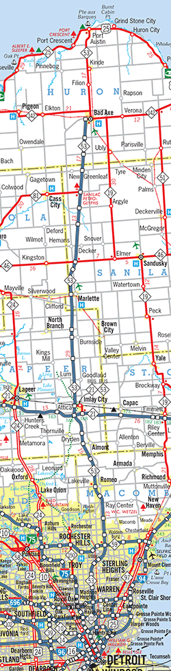
Route Map of M-53 |
| Notes: |
  M-53 is a relatively straight state highway route running due northerly from Detroit through western Macomb, eastern Lapeer, western Sanilac and central Huron Counties and terminating at the very tip of the Thumb region of Michigan. The "Thumb" is named as such as it juts out of the side of the Lower Peninsula, or "the Mitten." The region consists of Huron, Tuscola and Sanilac Cos with all or portions of Lapeer and St Clair also included. As state trunkline routes were initially consecutively assigned, beginning with "10," M-53 was the 44th route created starting in 1913 but quickly became an important route both providing access from the Metro Detroit area to the Thumb as well as a key "farm-to-market" route to get agricultural products from the fertile farmlands of the Thumb to market in a fast-growing Detroit. The well-organized "Earle Memorial Highway Association" strongly advocated for completion of paving along M-53 which helped cement its position (no pun intended!) as an early major route in the region. Indeed, in the late 1950s and early 1960s, the Michigan State Highway Dept included M-53 in its freeway plans, with nearly the entire route being converted to a freeway from I-94/Edsel Ford Frwy in Detroit all the way to Bad Axe in central Huron Co. In the end, only the portion from Sterling Heights northerly past Utica and Romeo was upgraded to freeway or expressway and the remaining plans were permanently shelved, although a full freeway-to-freeway interchange between I-696/Walter P Reuther Frwy and Mound Rd in Warren remains as a remnant of these plans. M-53 is a relatively straight state highway route running due northerly from Detroit through western Macomb, eastern Lapeer, western Sanilac and central Huron Counties and terminating at the very tip of the Thumb region of Michigan. The "Thumb" is named as such as it juts out of the side of the Lower Peninsula, or "the Mitten." The region consists of Huron, Tuscola and Sanilac Cos with all or portions of Lapeer and St Clair also included. As state trunkline routes were initially consecutively assigned, beginning with "10," M-53 was the 44th route created starting in 1913 but quickly became an important route both providing access from the Metro Detroit area to the Thumb as well as a key "farm-to-market" route to get agricultural products from the fertile farmlands of the Thumb to market in a fast-growing Detroit. The well-organized "Earle Memorial Highway Association" strongly advocated for completion of paving along M-53 which helped cement its position (no pun intended!) as an early major route in the region. Indeed, in the late 1950s and early 1960s, the Michigan State Highway Dept included M-53 in its freeway plans, with nearly the entire route being converted to a freeway from I-94/Edsel Ford Frwy in Detroit all the way to Bad Axe in central Huron Co. In the end, only the portion from Sterling Heights northerly past Utica and Romeo was upgraded to freeway or expressway and the remaining plans were permanently shelved, although a full freeway-to-freeway interchange between I-696/Walter P Reuther Frwy and Mound Rd in Warren remains as a remnant of these plans. |
| |
 Unlike most longer state trunkline highways in the state, nearly the entire length of the route bore one street name: Van Dyke. In every county and nearly every incorporated community along the way, M-53 is or was named Van Dyke Ave or Van Dyke Rd. Only the communities of Almont, Bad Axe and Port Austin have given M-53 a different street name and while Van Dyke Ave still runs along the former route of M-53 from Sterling Heights through Romeo in Macomb Co, the freeway and expressway portion of the route has been given other names. Additionally, in honor of early highway proponent and first State Highway Commissioner Horatio S. "Good Roads" Earle, M-53 in its entirety has been designated as the "Earle Memorial Highway." Unlike most longer state trunkline highways in the state, nearly the entire length of the route bore one street name: Van Dyke. In every county and nearly every incorporated community along the way, M-53 is or was named Van Dyke Ave or Van Dyke Rd. Only the communities of Almont, Bad Axe and Port Austin have given M-53 a different street name and while Van Dyke Ave still runs along the former route of M-53 from Sterling Heights through Romeo in Macomb Co, the freeway and expressway portion of the route has been given other names. Additionally, in honor of early highway proponent and first State Highway Commissioner Horatio S. "Good Roads" Earle, M-53 in its entirety has been designated as the "Earle Memorial Highway." |
| |
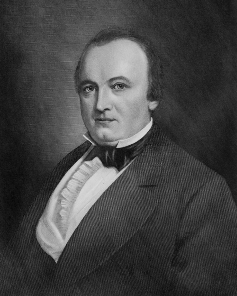 James A. Van Dyke (December 1813–May 7, 1855) was a lawyer who also served as Detroit City Attorney, Wayne County prosecuting attorney, city alderman, and as the 21st mayor of the CIty of Detroit in 1847. He was born born in Mercersburg, Pennsylvania, a member of the Whig party and "described as a brilliant and eloquent orator." Van Dyke was also president of the Detroit Fire Dept 1847–1851 and a commissioner on the Detroit Water Works board 1853–1855. He and his wife Elizabeth had eleven children. Van Dyke Ave on the east side of Detroit was named for him which was incorporated into the route of Trunk Line 53 (now M-53) and the name was carried north with the highway designation so that, over time, nearly all of the route of M-53 bore the same street name all the way to Port Austin. A community named Van Dyke was platted along its namesake roadway in southern Warren Twp just across the northern boundary of Detroit, but was later incorporated into the City of Warren in 1957, although the Van Dyke Public School district still survives in the area to this day. Van Dyke also had its own U.S. Post Office from 1925 to 1957. James A. Van Dyke (December 1813–May 7, 1855) was a lawyer who also served as Detroit City Attorney, Wayne County prosecuting attorney, city alderman, and as the 21st mayor of the CIty of Detroit in 1847. He was born born in Mercersburg, Pennsylvania, a member of the Whig party and "described as a brilliant and eloquent orator." Van Dyke was also president of the Detroit Fire Dept 1847–1851 and a commissioner on the Detroit Water Works board 1853–1855. He and his wife Elizabeth had eleven children. Van Dyke Ave on the east side of Detroit was named for him which was incorporated into the route of Trunk Line 53 (now M-53) and the name was carried north with the highway designation so that, over time, nearly all of the route of M-53 bore the same street name all the way to Port Austin. A community named Van Dyke was platted along its namesake roadway in southern Warren Twp just across the northern boundary of Detroit, but was later incorporated into the City of Warren in 1957, although the Van Dyke Public School district still survives in the area to this day. Van Dyke also had its own U.S. Post Office from 1925 to 1957. |
| |
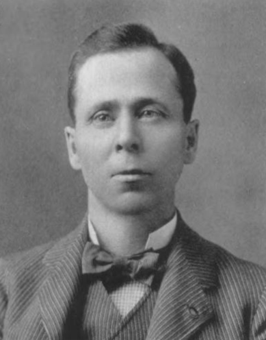 Horatio S. "Good Roads" Earle (February 14, 1855–December 25, 1935) was a native of Mount Holly, Vermont and held a variety of jobs before settling on selling and developing agricultural implements after moving to Detroit in 1889. Earle was an early advocate of the "Good Roads Movement" as high-ranking member of the Michigan division of the League of American Wheelmen, a cyclists association promoting the improvement of roads and highways in the U.S. prior to the arrival of the automobile. Earle kept with the Goods Roads Movement as it transitioned to motorcar users at the turn of the 20th Century and was elected as a state senator. In 1901, he helped create the State Highway Commission and was elected as its first chairperson and a year later he founded the American Road Makers, known today as the American Road & Transportation Builders Association. Earle became State Highway Commissioner in 1903 after introducing legislation which created the State Highway Dept (now the Michigan Dept of Transportation or MDOT), although it was voided by the attorney general as unconstitutional. That was rectified in 1905 with a constituional amendment creating the department, resulting in Earle becoming what he liked to say was both "the first unconstitutional and first consitutional State Highway Commissioners." He later lost in the primary elections for Governor in 1908 and 1920 and also unsuccessfully ran for mayor of Detroit in 1912. (In a somewhat interesting coincidence, Earle's first child, born in 1878, was named Romeo Horatio Earle—and M-53 as the Earle Memorial Highway passed through the Village of Romeo in Macomb Co!) Horatio S. "Good Roads" Earle (February 14, 1855–December 25, 1935) was a native of Mount Holly, Vermont and held a variety of jobs before settling on selling and developing agricultural implements after moving to Detroit in 1889. Earle was an early advocate of the "Good Roads Movement" as high-ranking member of the Michigan division of the League of American Wheelmen, a cyclists association promoting the improvement of roads and highways in the U.S. prior to the arrival of the automobile. Earle kept with the Goods Roads Movement as it transitioned to motorcar users at the turn of the 20th Century and was elected as a state senator. In 1901, he helped create the State Highway Commission and was elected as its first chairperson and a year later he founded the American Road Makers, known today as the American Road & Transportation Builders Association. Earle became State Highway Commissioner in 1903 after introducing legislation which created the State Highway Dept (now the Michigan Dept of Transportation or MDOT), although it was voided by the attorney general as unconstitutional. That was rectified in 1905 with a constituional amendment creating the department, resulting in Earle becoming what he liked to say was both "the first unconstitutional and first consitutional State Highway Commissioners." He later lost in the primary elections for Governor in 1908 and 1920 and also unsuccessfully ran for mayor of Detroit in 1912. (In a somewhat interesting coincidence, Earle's first child, born in 1878, was named Romeo Horatio Earle—and M-53 as the Earle Memorial Highway passed through the Village of Romeo in Macomb Co!) |
| Notes: |
While the non-limited-access portion of M-53 is named Van Dyke Ave/Rd over nearly its entire length, the limited-access portions have received their own designations. The freeway segment constructed in the 1960s from Sterling Heights northerly past Utica to the Washington area of Macomb Co has been designated the Christopher Columbus Freeway, although residents and local media very rarely refer to it as such, especially with more recent negative connotations with regard to Columbus. The expressway segment of M-53 from the Washington area northerly past Romeo to 34 Mile Rd in Macomb Co has been designated the POW/MIA Freeway, although this stretch of highway is not built to freeway standards. |
| |
In the late 1960s and into the 1970s, the Dept of State Highways planned to extend the M-53 freeway from its southern end in Sterling Heights westerly along 18½ Mile Rd for a mile, turning southerly to run along the Mound Rd corridor through the remainder of Sterling Heights and Warren and into Detroit, where it would connect with an eastern extension of the Davison Frwy (now M-8) before deflecting southeasterly to connect with I-94/Edsel Ford Frwy. Right-of-way for the freeway connection between Van Dyke Ave and Mound Rd along 18½ Mile Rd and then southerly on the west side of Mound Rd southerly to Branch St (approximately "17½ Mile") was purchased by the State from 1968 to 1979 and held for many years. Although the freeway plans were eventually shelved, especially after the City of Detroit prohibited any new freeways from being built in their city in the early 1970s, one credible source related to this website's author in the early 2000s plans to move M-53 over to Mound Rd in Sterling Heights and Warren were still being planned for, at some level. At the time, MDOT's Metro Region was in the design stage with "plans for the proposed ramps and 5-lane cross section of 18½ Mile Road...being developed to reconfigure the connection between M-53 and Mound Road." Under these plans, M-53 would move over to Mound Rd, which would have remained as a 6–8 lane divided urban boulevard, while Van Dyke Ave from 18½ Mile Rd south to 8 Mile Rd would have been offered back to the local jurisdictions. 18½ Mile Rd was, indeed, improved as indicated during 2004–05, being widened from a largely two-lane rural roadway into a five lane, partially divided highway, with a roundabout where new M-53 freeway ramps intersect with Van Dyke Ave, along with a new westerly approach to Mound Rd that angles to the southwest, theoretically making for an easier transition for trunkline-type traffic between 18½ Mile and Mound Rds. However, no other actions toward moving M-53 onto Mound Rd have taken since, so it would seem those plans have been shelved at this time. Additionally, MDOT essentially put a nail in the coffin of any plans to extend the M-53 freeway along the 18½ Mile corridor to Mound Rd, with the department selling off most of the freeway ROW acquired duing the 1970s beginning in 2007 and continuing through 2015. |
| |
After the M-53 freeway bypass of the Utica and Washington areas was competed in late 1965, plans to extend the improvements to the north toward the proposed M-21 freeway at Imlay City (present-day I-69) remained in limbo. Finally, work on the "Romeo Bypass," a northerly extension of the M-53 freeway from the Washington area past Romeo to 34 Mile Rd in northwest Macomb Co began in the late 1980s. Constructed on a freeway right-of-way and originally intended to be a freeway extension, when it opened in 1991, the Romeo Bypass consisted of a "Super 2" expressway—a limited-access undivided two-lane road where some intersecting roads were grade-separated (overpassed or underpassed) while others featured intersections with traffic signals. The "downgrade" from full freeway was likely made due to budgetary issues, but it did accomplish part of the goal to remove heavy traffic from the overburdened old route through downtown Romeo. Over a decade later, MDOT upgraded the "Super 2" to a fully divided, four-lane limited-access expressway with the addition of new northbond lanes completed in 2004. There is some indication there are long-term plans for interchanges for the remaining intersections at the Van Dyke Rd connector and 30 Mile and 32 Mile Rds, but these may be many years into the future. (Interestingly, the Van Dyke Rd connector is signed as Exit 25 northbound, although it is a left-hand "ramp" that meets the southbound lanes at a signalized intersection.) |
| |
In an interesting twist, in 2006, MDOT and MSP increased the speed limit along the four-lane "expressway" portion of the Romeo Bypass. However, since that portion of highway is not officially a freeway and since Michigan has no "middle ground" in speed limits—freeways can be signed at 70–75 mph, while ALL other roads are limited to 55 mph or less, even if they are nearly freeway—the portions of the bypass between the remaining intersections is now posted at 70 mph, with very short 55 mph segments right at the intersections. Site visitor Mike Baysdell even notes the speed limit jumps back up to 70 mph before you get to the Michigan Left turnarounds! A 70 mph freeway speed limit on an expressway-quality road with interections is rather odd, although assigning an appropriate and reasonable speed limit despite these idiosyncracies is refreshing... —Many thanks to Mike! |
| |
In "State Trunkline Needs, 1960–1980," a set of maps prepared by the State Highway Dept's Office of Planning, Programming Division in 1960 showing possible additions, upgrades and improvements to the state trunkline system over the ensuing twenty years, MSHD staff recommended many changes to the route of M-53 during that timeframe, including:
- Constructing an M-53 freeway from an upgraded US-25/Gratiot Ave "Freeway" in Detroit northerly, generally in the Mount Elliot St corridor from Gratiot to Caniff Ave, then in the Mound Rd corridor from Caniff northerly to M-102/Eight Mile Rd. This proposal was never implemented.
- In Macomb Co, the proposed M-53 freeway was to shift to the west from an interchange at M-102/Eight Mile Rd & Mound Rd and run approximately ½ mile west and parallel to Mound Rd northerly to 16 Mile Rd where it would bend northeasterly to intersect the existing route of M-53 at 18 Mile Rd. From there the M-53 freeway would turn back northerly to run to approximately 1¼ miles east of the existing route, through a freeway-to-freeway interchange with a proposed M-59 freeway at 21 Mile Rd, then northerly before crossing back over its existing route (with an interchange) at 30 Mile Rd. The proposed freeway would then bypass Romeo to the west and continue due northerly to about 34 Mile Rd where it would bend slightly to the west and proceed into Lapeer Co. Within five years of this proposal, an M-53 freeway was completed from 18 Mile Rd in Sterling Twp (south of Utica) northerly to 27½ Mile Rd at Washington south of Romeo. Almost 30 years later, an eastern bypass of Romeo was completed (as an expressway instead of freeway). The remainder of the proposal for M-53 in Macomb Co was never realized.
- In Lapeer Co, the proposed M-53 freeway was to continue northerly within two miles of the existing route bypassing Almont and Imlay City to the west, with a freeway-to-freeway interchange with a proposed M-21 freeway southwest of Imlay City. A BUS M-53 was proposed for Imlay City beginning at the M-52 & M-21 freeway interchange and proceeding easterly via the M-21 freeway to the existing route of M-53, then north into Imlay City concurrently with a proposed BUS M-21 routing, where it would then turn westerly via 4th St to Blacks Corners Rd then along a new alignment to an interchange with the M-53 freeway. (The proposed BUS M-21 would continue southerly along the M-53 freeway from this point back to its parent route southwest of Imlay City.) None of this proposal was ever put into place.
- The proposed M-53 freeway was to continue northerly into Sanilac and Huron Cos, bypassing Marlette to the west before crossing over the existing M-53 approximately one mile south of M-46 where it then was to proceed northerly on an alignment bearing slightly to the east to a terminus at the existing route of M-53 on the western limits of the City of Bad Axe. While the planning maps show the proposed freeway ending at M-53 west of downtown Bad Axe, they are drawn in such a way that a northerly extension could be easily tacked on in the future, if desired, facilitating a bypass of the city. As with Lapeer Co, none of this proposal in Sanilac and Huron Cos was ever implemented.
|
| History: |
1913—1920 – Trunk Line 53 (T.L. 53) is officially established as a state trunkline route over the course of seven years from 1913 to 1920 in various segments:
- 1913 (July 5) – The first 2.2-mile segment of T.L. 53 is established, in of all places, southwest Sanilac Co due to its relation with the establishment of the route of T.L. 38 (later M-38) in the area. The segment begins at Montgomery Rd on the Lapeer/Sanilac Co line and continues northerly via Van Dyke Rd to the Marlette south village limit.
- 1914 (June 20) – The second segment of T.L. 53 to be established is the five-mile stretch of Van Dyke Rd in northeast Lapeer Co from Montgomery Rd on the Sanilac Co line southerly to Burnside Rd, which is also established to the east (toward Brown City) on the same day at part of the T.L. 38 (later M-38, now M-90) route.
- 1919 (Nov 14) – Five years pass before another portion of T.L. 53 is established from the Marlette south village limit northerly along Van Dyke Rd for 25 miles to the Huron/Sanilac Co line at Huron Line Rd.
- 1920 (Mar 23) – T.L. 53 is established through most of Macomb Co in three segments:
- The 12.0-mile segment from 8 Mile Rd on the Wayne/Macomb Co line northerly along Van Dyke Ave to Utica Rd south of Utica, then northwesterly via Utica Rd, northeasterly on Greeley St, and northerly via Davis St to T.L. 59 (later M-59) at Auburn Rd west of downtown Utica.
- From the Utica north city limit (0.6 mile north of Auburn Rd) northerly along Van Dyke Rd for 12.0 miles to the Romeo south village limit.
- And finally fhe 6.5-mile stretch from 32½ Mile Rd on the Romeo north village limit northerly to Bordman Rd on the Macomb/Lapeer Co line.
- 1920 (May 10) – The 6.0-mile segment of T.L. 53 (M-53) from Huron Line Rd on the Sanilac/Huron Co line northerly to Kilmanagh Rd/Popple Rd in Popple is officially established.
- 1920 (June 1) – The remaining 5.0 miles of M-53 in Huron Co are established from Van Dyke Rd at Popple westerly for a mile along Kilmanagh Rd, then northerly four miles via Grassmere Rd to the terminus of M-53 at M-31/Pigeon Rd (present-day M-142) east of Elkton.
- 1920 (June 9) – The 1.25-mile portion of M-53 through the Village of Romeo in Macomb Co is established from the south village limit notherly to 32½ Mile Rd at the north village limit.
- 1920 (July 1) – The 0.6-mile stretch of Van Dyke Rd in Utica from M-59/Auburn Rd downtown northerly to the north city limit is officially established as part of M-53.
- 1920 (Nov 30) – The first 4.3 mile portion of M-53 in Wayne Co, from Harper Ave in Detroit northerly to 8 Mile Rd on the Macomb Co line, is established as a state trunkline route.
- 1920 (Dec 20) – The remaining 23.6-mile stretch of M-53 in Lapeer Co from Bordman Rd on the Macomb Co line northerly through Almont and Imlay City to M-38 [EAST] at Burnside Rd in Burnside is established.
|
| |
1920 (Apr–June) – T.L. 53 is signed in the field as M-53 as all state trunkline highways in the Lower Peninsula of Michigan are signed with route markers. While there are gaps in the officially established state trunkline route within various incorporated communities, those gaps, consisting of locally-controlled roadway segments, are still signed as part of the route of M-53.
M-53's signed route consists of: Van Dyke Ave northerly from M-19/Gratiot Ave in Detroit through Centerline and Utica to Washington. From there, M-53 cuts east for one mile on 27 Mile Rd, then northerly via Jewell Rd and Main St into Romeo. M-53 continues northerly from Romeo via Van Dyke Rd, west and north along Kidder Rd, westerly via 37 Mile Rd, northerly via Hipp Rd back to Van Dyke Rd at the Lapeer/Macomb Co line. In Lapeer Co, M-53 continues northerly on Van Dyke Rd through Almont, then northerly on Howland Rd, westerly via Hollow Corners Rd, northerly on Van Dyke Ave, west along Hunters Creek Rd, then north on Fairground Rd into Imlay City. From Imlay City, M-53 runs northerly via Almont Ave, Fairground Rd and Seabury Rd back to present-day Van Dyke Rd, then northerly on Van Dyke Rd into Sanilac Co and Marlette. There, M-53 turns westerly from Main St onto Marlette St for three blocks, then northerly again via Lamotte St to present-day Van Dyke Rd north of town. Northerly via Van Dyke Rd through Sanilac Co into Huron Co. At Popple five miles southwest of Bad Ave, M-53 leaves Van Dyke Rd to head west on Kilmanagh Rd and north via Grassmere Rd, ending at M-31 (later M-83, present-day M-142) four miles east of Elkton. |
| |
1921 (Dec 14) – M-53 is rerouted in southeast Lapeer Co between Almont and Imlay City. The 1.5-mile portion along Howland Rd from Dryden Rd northerly to Hollow Corners Rd, then west via Hollow Corners Rd to Van Dyke Rd is cancelled as a state trunkline route and turned back to county control. The 1.5-mile segment along Dryden Rd from Howland Rd westerly to Van Dyke Ave, then northerly on Van Dyke Ave to Hollow Corners Rd is established as the new trunkline route. |
| |
1922 – Maps show M-53 in Detroit may have followed a different route from M-19/Gratiot Ave northerly along Mount Elliot Rd, then easterly along Seven Mile Rd to Van Dyke Ave (as opposed to continuing southerly via Van Dyke directly to Gratiot). Additionally, some maps show M-53 being rerouted westerly from Mount Elliot along Seven Mile Rd, then northerly on Mound Rd to Eight Mile Rd, then back easterly to Van Dyke Rd. As the portion of Van Dyke Ave from Harper Ave north to Eight Mile Rd has already been established as the route for M-53, it is unclear whether these other mapped routes are signed in the field as part of M-53 or not. |
| |
1923 (Mar 12) – The northernmost five miles of M-53, from the hamlet of Popple in south central Huron Co westerly for a mile along Kilmanagh Rd, then northerly four miles via Grassmere Rd to M-31 (later M-83, present-day M-142) is cancelled as a trunkline route, replaced by the establishment of the 6.2-mile segment of Van Dyke Rd form Kilmanagh Rd at Popple then northeasterly and easterly into Bad Axe where it now terminates as M-19 & M-31 downtown. (The new highway likely opens to traffic around this time or sometime later in 1923.) |
| |
1923 (Fall) – Work on concrete paving of M-53 between Washington and Romeo in west-central Macomb Co is completed, including a realignment of the route via present-day Van Dyke Ave and removal from the 27 Mile Rd and Jewell Rd route, however the new alignment will not be officially established as a trunkline route nor will the former route be cancelled and turned back to local control for 3½ years, for unknown reasons at present. |
| |
1925 – As noted in the 1922 listing above, the route of M-53 in Detroit is somwhat unclear in the earlier years, likely having to do with most trunkline routes not being officially established through incorporated cities (until 1931). Having been depicted on maps running northerly from M-19/Gratiot Ave along Mount Elliot Ave, Seven Mile Rd, Mound Rd, and Eight Mile Rd—likely a marked-and-maintained route—it is now shown to utilize van Dyke Ave all the way south from Eight Mile Rd to M-19/Gratiot Ave (later US-25, now M-3). Oddly, the segment of Van Dyke Ave from Eight Mile Rd southerly to Harper Ave (within 0.7 mile of Gratiot Ave) has been the officiall established route for M-53 since November 1920. |
| |
1927 (Apr 1) – The 2.1-mile long M-53 realignment between Washington and Romeo in west-central Macomb Co which was completed and opened to traffic 3½ years earlier is finally established as a state trunkline route from 27 Mile Rd northerly and northeasterly to Jewell Rd, while the former route along 27 Mile Rd from Van Dyke Rd easterly to Jewell Rd and Jewell from 27 Mile north back to Van Dyke, is cancelled and turned back to county control. |
| |
1927 (May 2) – Beginning May 2, all M-19 route markers on that portion of the route from Bad Axe northerly to Port Austin are temporarily covered with new M-53 signs marking the start of the myriad route changes due to the debut of the U.S. Highway System in Michigan. The temporary markers will be swapped out for permanent signs in the coming weeks when they area available. Also signed along M-19–turned–M-53 from Bad Axe northerly is M-29 until the new shoreline scenic alignment for that route from Port Austin through Caseville to Bay Port is completed. (M-19 now terminates at M-83, formerly M-31, east of Bad Axe.) |
| |
1927 (Aug 25) – A new, direct 0.7-mile long route for M-53 is established at Utica along Van Dyke Ave from Utica Rd south of town northerly to the existing route at Auburn Rd downtown, one block north of M-59/Hall Rd. The former 0.8-mile route via Utica Rd from Van Dyke Ave northwesterly and northerly to Greeley St, then northeasterly along Greeley St and northerly again on Davis St to M-59/Auburn Rd, as well as the 0.05-mile former route of M-53 via the one block of Auburn Rd from Cass Ave east to Van Dyke Ave, are cancelled as state trunklines and turned back to local control. The new route of M-53 along Van Dyke between Utica Rd and Auburn Rd is likely open to traffic by the end of the construction season. |
| |
1928 (Jan 9) – A new 0.8-mile alignment of M-53 is officially established in northwest Macomb Co, from the cnr of Van Dyke Ave & Kidder Rd northerly before curving to the west along 37 Mile Rd back to Kidder Rd and the former 0.6-mile route along Kidder Rd from Van Dyke Ave to 37 Mile Rd is cancelled and turned back to county control. |
| |
1928 (July 11) – The Detroit City Council approves the request made jointly by Grover C Dillman, State Highway Dept engineer, and John W Reid, commissioner of public works, to erect route markers on the various streets in Detroit carrying state trunkline highway routes. M-53 is to be signed along Van Dyke Ave from the northern city limit southerly to US-25/Gratiot Ave. |
| |
1929 (Mar 14)—1930 (June 4) – The last 1¾ mile of new concrete pavement is opened to traffic on June 4, 1930 as part of an overall project involving two realignments and the completion of hard-surfacing on M-53 between Almont and Imlay City in southeast Lapeer Co. The new route utilizes the majority of the former right-of-way for the Detroit, Almont & Northern (DA&N) Railway, an interurban line serving as an extension of the lines serving the greater Detroit area northerly from Romeo through Almont to Imlay City.
Service on the DA&N Ry had been suspended since July 6, 1927 in a time when many interurban routes are failing due to the rising use of personal automobiles. With the exception of the portion through the Village of Almont, the DA&N Ry had run imnmediately adjacent to M-53 from north of Romeo to Imlay City. Workmen employed by the Detroit United Electricy Railway, owners of the DA&N, began tearing out the rails and overhead lines which powered the trains on December 28, 1928. The State Highway Dept decided to use the portions of the DA&N ROW to either expand the exisitng highway, where it ran alongside, or for the realignment of the route to remove dangerous 90° turns and other hazards. From Main St on the north side of Almont (just south of North St), M-53 is relocated onto a new alignment running northwesterly for ⅓ mile to the former DA&N ROW, then along the former interurban route for 0.54 mile to Tubspring Rd. There, M-53 now continues due northerly via the DA&N ROW for a mile to the existing route at Dryden Rd, continuing three miles along the upgraded existing highway to Hunters Creek Rd, departing there to follow the former DA&N ROW for 1.8 miles to Borland Rd, then lateraling west via Borland for ¼ mile back to existing M-53 at Fairgrounds Rd–Almont Ave, where it turns northerly into downtown Imlay City.
The existing route of M-53 along Main St from St Clair St in downtown Almont continuing northerly via Howland Rd, then westerly on Dryden Rd to Van Dyke Rd and along Hunters Creek Rd from Van Dyke Rd westelry and then northerly along Fairgrounds Rd to Borland Rd on the south edge of Imlay City is cancelled as a state trunkline route on March 14, 1929. The majority of the new route, opened to traffic on June 4, 1930, is officially established as the new route for M-53 at the same time, even though completion of the project is still more than a year off. Interestingly, it was the former DA&N Ry ROW within the Village of Almont from the north ending at St Clair St that is established as the M-53 route, while the actual roadway departs the former interurban route near the north village limit to run southeasterly back to Main St. Thus, N Main St from St Clair St northerly to the new M-53 route, and that segment of the new M-53 route from N Main St northwesterly to the DA&N ROW is not the established trunkline route (technically being a "marked-and-maintained" route) while the former interurban route, with no roadway constructed on it, is the established route. (This incongruity would not be corrected for nearly a decade-and-a-half.) |
| |
1930 (Aug 22, Sept 12) – The majority of the former right-of-way for the Detroit, Almont & Northern (DA&N) Railway from Romeo through Almont to Imlay City, is purchased by the State Highway Dept and used to widen and/or straighten the route of M-53 between Romeo and Imlay City, completed and opened to traffic that June (see above). The portion of the ROW in Lapeer Co is bought on August 22, with the part in Macomb Co purchased three weeks later on September 12. |
| |
1931 (May 19) – Act 131 of 1931—the Dykstra Act—is passed allowing the State Highway Dept to take over control of state highways running into and through incorporated cities, thereby officially incorporating them as state trunkline highways. The following segment of formerly city-controlled street is assumed into the system as part of M-53:
- In Detroit: The 0.7-mile segment of Van Dyke Ave from US-25/Gratiot Ave northwesterly to Harper Ave. (Van Dyke north of Harper had been an officially established trunkline route since 1920.)
|
| |
1931 (June 29, Aug 31) – A new realignment of M-53 in east-central Lapeer Co immediately north of Imlay City is completed and opened to traffic on June 29. From jct M-21 & M-53 (at cnr N Almont Ave–Fairgrounds Rd & Capac Rd) north of downtown Imlay City, M-53 now turns easterly with M-21 via Capac Rd for ⅓ mile, then turns northerly along the newly-built segment of Van Dyke Rd for 1.3 miles, merging back with the former route at Seabury Rd. A month later on August 31, the new 1.3-mile route along Van Dyke Rd between M-21/Capac Rd and Seabury Rd is established as a state trunkline highway, while the former 1.3-mile route via Fairground Rd from M-21/Capac Rd northerly and Seabury Rd northeasterly to the new M-53 route at Van Dyke Rd is cancelled as a trunkline and turned back to local control. This realignment is part of the effort to continue the paving of M-53 from Imlay City northerly into the Thumb region. |
| |
1935 (July 15, Oct 28)—1936 (Feb 20) – The final "phase" in an overall set of projects to pave, modernize and straighten the route of M-53 in Lapeer Co from Almont to north of Imlay CIty is completed when a 1.146-mile segment of relocated highway opens to traffic at Imlay City on July 15, 1935. The new route begins where the 1930 improvements from the south left off at the cnr of Van Dyke Rd & Borland Rd and continues northery to Engle St, then bends northeasterly to pass under the Grand Trunk Western Ry (now Canadian National) line via a new $70,000 underpass before bendig back northerly taking over a stretch of exisiting Cedar St and meeting up with the 1931 relocation at M-21/Capac Rd. The new route eliminates four 90° turns, one railroad grade crossing, and removes the route from the central business district as M-53 now passes through the eastern edge of Imlay City.
The 0.646-mile portion of the new route from Borland Rd northerly through the GTW underpass to Third St is officially established as a state trunkline route 3½ months later on October 28, 1935, while the remainder of the realignment from third St northerly via the former Cedar St to the jct of M-21 & M-53 at the cnr of Capac & Van Dyke Rds is established several months later on February 20, 1936. It's at this time that the 1.3-mile former route of M-53 through downtown Imlay City via Borland Rd from Van Dyke Rd west to Almont Ave and Almont Ave from Borland Rd northerly to M-21/Capac Rd is cancelled as a trunkline route and turned back to municipal control. |
| |
1939 (Apr 11) – While the route had been supported by an organization calling itself the "Earle Memorial Highway Assoication" since 1919, M-53 is officially designated as the "Earle Memorial Highway" by Murray D. Van Wagoner, State Highway Commissioner, to honor Michigan's first State Highway Commissioner, Horatio S. "Good Roads" Earle who passed away on Christmas Day, 1935. The request to make the designation official was made by Earle's family. |
| |
1942 (Aug 17)—1943 (Feb 26) – Assumedly to rectify a disparity between the officially established route of M-53 at Almont and the actual, physical signed route, two state trunkline establishments and one trunkline cancellation are carried out. First, on August 17, 1942, the 0.862-mile segment of the existing, signed route of M-53 along Van Dyke Rd from Main St on the north side of Almont northwesterly to Tubspring Rd is officially established as a trunkline. Then, over six months later, the 0.4-mile stretch of Main St from St Clair St downtown northerly to where the route turns northwesterly via Van Dyke Rd is officially re-established as a trunkline route. This portion had been cancelled in March 1929 as part of the establishment of a new alignment using the abandoned Detroit, Almont & Northern Ry interurban right-of-way, although none of the former interurban route was used wit hin the village, so the 5¾-block portion of Main St has remained signed as a "marked-and-maintained" portion of M-53 for the past 13 years. Then on February 26, 1943, the one-mile segment of the former DA&N Ry right-of-way from Tubspring Rd southerly into Almont to St Clair St, most of which was never converted into a roadway of any kind over this stretch, is (finally) cancelled as a state trunkline highway route. |
| |
1940 (Oct 21) – The final 9-mile segment of unpaved M-53 is fully paved, from M-81 in northwest Sanilac Co notherly into Huron Co at Ownedale Rd. State Highway Cpmmissioner Murray D. Van Wagoner cuts a ribbon reopening the highway at 5:00 pm at the jct of M-53 & M-81, after which he travels to Bad Axe to serve as featured speaker at a banquet held by the Earle Memorial Highway Association celebrating the completion of paving of the highway. In addition to other regional dignitaries, John R. Earle, grandson of Horatio S. "Good Roads" Earle for whom the highway is dedicated, also speaks at the ceremony. |
| |
1948 (Late June)—1949 (Nov 10) – A 2.28-mile relocation of M-53 in northwest Macomb Co from north of Kidder Rd to just north of the Lapeer Co line at Borland Rd is completed and opened to traffic in Late June 1948. The new alignment consists of two widely sweeping curves replacing two sharper ones and cuts approximately ½ mile off the length of the route. Over 16 months later on November 10, 1949, the new 1.829-mile section of M-53/Van Dyke Ave is officially established as a trunkline route, while the 1.7-mile section along 37 Mile and Hipp Rds is cancelled and turned back to county control and the 0.6-mile stretch lying to the east of the newly-relocated highway is cancelled and obliterated as a public roadway. |
| |
1948 (Oct 1)—1949 (Nov 10) – A ¾-mile relocation of M-53 north of downtown Marlette, from Angle St northwesterly to Lamotte St, is completed and opened to traffic on October 1, 1948. The new alignment features two widely sweeping curves replacing two sharper ones and shaves about 170 feet off the length of the route. Over 13 months later on November 10, 1949, the new 0.768-mile section of M-53/Main St is officially established as a trunkline route, while the 0.7-mile section along Angle and Lamotte Sts is cancelled and turned back to local control. |
| |
1952 – Three miles of divided highway are completed along M-53 between 14 Mile and 17 Mile Rds in Sterling Twp (present-day Sterling Heights) north of Warren. |
| |
1953 – An additional two miles of divided highway are open between 12 Mile and 14 Mile Rds in Warren. |
| |
1965 (Nov 10, 11am)—1966 (July 5) – The 11½-mile long M-53 Freeway is completed and opened to traffic from 18 Mile Rd in Sterling Twp (south of Utica) northerly to 27½ Mile Rd at Washington south of Romeo with a ribbon-cutting at Utica at 11:00am on November 10, 1965. (Plans, which were never realized, were to continue the M-53 freeway southerly via the Mound Rd corridor to a proposed connection with an extended Davison Frwy, then on to the I-94/Edsel Ford Frwy in Detroit.) Eight months later on July 5, 1966, the 10.895-mile segment of the M-53 freeway is officially estalioshed as a state trunkline highway, while the 10.120-mile former M-53 along Van Dyke Ave between the ends of the new freeway segment is cancelled as a trunkline and turned back to local control. |
| |
1970 (Jan 20, Sept) – Planning is underway for the M-53 freeway in Macomb Co from I-696/Walter P Reuther Frwy in Warren northerly along Mound Rd to 18½ Mile Rd in Sterling Heights, then jogging easterly along 18½ Mile to the southern end of the existing M-53 freeway near Utica. A Corridor Public Hearing is held on January 20 and the Dept of State Highways requests location approval from the Federal Highway Administration (FHWA) in September. (Purchasing of right-of-way by the department began in June 1969.) |
| |
1989 – Construction on the "Romeo Bypass" begins. This route is designed to be a freeway bypass of Romeo from the northern end of the current freeway to 34 Mile Rd. |
| |
1991 (Sept 26) – The 7.591-mile "Romeo Bypass" between 27½ Mile and 34 Mile Rds in Macomb County is officially established as a state trunkline highway route, although completion of the new highway and its opening to traffic will not occur until the next year. (The existing route of M-53 is unaffected.) |
| |
1990–91 (Winter) – During the winter of 1990–91, the first 5.2 miles of the "Romeo Bypass" is completed and opened to traffic from the "Van Dyke Cutoff" just north of 27½ Mile Rd northerly to 32 Mile Rd east of downtown Romeo. M-53 traffic is temporarily routed back the former route along Vak Dyke Ave using 32 Mile Rd until the remainder of the bypass is completed. The former route of M-53 remains an unsigned state trunkline route at this point. |
| |
1991 (Aug 19) – The remaining 3.1 miles—the northernmost segment—of the Romeo Bypass is completed and opened to traffic between 32 Mile Rd east of downtown Romeo and 34 Mile Rd north of Romeo. As noted in the "Notes" section above, the bypass is opened initially as a two-lane, limited-access expressway, with a mix of both overpasses and intersections at crossroads. The former route of M-53 along Van Dyke Rd through Romeo, as well as the new "Van Dyke Connector," remains an unsigned state trunkline highway internally designated by MDOT as OLD M-53. |
| |
2001 (July 6) – The 3.17-mile segment of OLD M-53 along Van Dyke Ave from 31 Mile Rd south of Romeo to 34 Mile Rd north of Romeo in Macomb Co (as well as the 0.20-mile segment of the former M-53 from the northern conenctor to a cul-de-sac immediately south of 34 Mile Rd) is transferred from MDOT to County jurisdiction, nearly a decade after the Romeo bypass was completed. As part of the transfer, MDOT completes restoration work on the route, while Macomb Co agrees to install a traffic signal at the intersection of Van Dyke & Durham St on the southern edge of Romeo. |
| |
2002 (Dec 19) – Cancellation as an (unsigned) state trunkline of the remainder of OLD M-53 (Van Dyke Ave) in the Romeo area is completed when 3.642 miles of Van Dyke Ave from the Van Dyke Cutoff northerly to 31 Mile Rd south of Romeo and the 0.174-mile Van Dyke Cutoff between M-53 and Van Dyke Rd are transferred to County control. All parts of Van Dyke Ave (OLD M-53) superseded by the "Romeo Bypass" have now been cancelled as state trunkline highway routes and turned back to local control. |
| |
2002–04 – Construction on the new northbound lanes of the "Romeo Bypass" occurs. While intersections remain at two locations along the bypass, the limited-access expressway now has four lanes separated by a median all the way past Romeo. |
| |
2004–05 – The construction of an interchange at the southern end of the M-53 freeway in Sterling Heights where it meets Van Dyke Ave & 18½ Mile Rd (now signed as Exit 15), a roundabout at Van Dyke & 18½ Mile, and the upgrading of 18½ Mile Mile from Van Dyke Rd westerly to Mound Rd, which would accommodate a realigning of M-53 onto Mound Rd from 18½ Mile Rd southerly through Sterling Heights and Warren, is completed. However, M-53 remains routed along Van Dyke Ave and Mound Rd remains a county primary roadway. |
| |
2024 (July 30, Dec 10) – On July 30, Governor Gretchen Whitmer signs House Bill 5151 of 2023 into law, thereby becoming Public Act 91 of 2024, designating the portion of M-53 from 17 Mile Rd northerly to M-59/Hall Rd as the "Officer Leroy Imus Memorial Highway" for a Sterling Heights police officer killed in the line of duty on December 2, 1971. Interestingly, on December 10 Whitmer approves House Bill 5717 repealing Act 91, replacing it with Act 166 pf 2024 which essentially revises the segment of M-53 involved to the 18 Mile-to-Hall Rd portion (narrowing down the memorial highway designation for Imus by one mile.) The city also has a park named for the slain officer off Dodge Park Rd, one mile east of M-53/Van Dyke Rd between 16 Mile and 16½ Mile Rds. (Thanks Izzy!) |
| Controlled Access: |
Using MDOT signage as the arbiter as to what is to be considered as freeway versus expressway (see explanation in the Notes section above), as oppoed to the "usual" methodology employed on this website, the following breakdown between the two along M-53 is made: |
| |
Freeway: In three segments in Macomb Co:
- From the 18½ Mile Rd/Van Dyke Rd interchange (Exit 15) in Sterling Heights to 27 Mile Rd north of Washington. (9.55 miles)
- From immediately north of the Van Dyke Rd connector at-grade intersection ("Exit 25") north of Washington to immediately south of the 30 Mile Rd intersection. (2.6 miles)
- From immediately north of the 30 Mile Rd intersection to immediately south of the 32 Mile Rd intersection east of Romeo (1.6 miles)
- From 2006–2018, the 1.7-mile segment of the M-53 Romeo Bypass from immediately north of 32 Mile Rd to the end of the limited-access roadway south of 34 Mile Rd was posted at the 70 mph freeway speed limit, however a new at-grade connector to 33 Mile and McKay Rds was built in 2018 "breaking" the freeway status, resulting in MDOT effectively "downgrading" the northernmost 2.3 miles of the Romeo Bypass to expressway status along with a 55 mph speed limit.
|
| |
Expressway: In three segments: in Macomb Co
- From the 27 Mile Rd overpass to immediately north of the Van Dyke Rd connector at-grade intersection ("Exit 25") north of Washington. (0.5 mile)
- From immediately south of the 30 Mile Rd intersection to immediately north of the 30 Mile Rd intersection. (0.5 mile)
- From immediately south of the 32 Mile Rd intersection east of Romeo to the end of the limited-access roadway south of Van Dyke Rd and 34 Mile Rd north of Romeo. (2.3 miles)
- See 2006–18 note in the "Freeway" section above.
|
| NHS: |
The segment of M-53 from its southern terminus at M-3/Gratiot Ave in Detroit to the northern jct of M-142 north of Bad Axe is on the National Highway System (NHS). (105 miles) |
| Circle Tour: |
 Lake Huron Circle Tour: From the southern jct of M-25 to the northern terminus of M-53 at the northern jct with M-25 in Port Austin. (0.4 miles) Lake Huron Circle Tour: From the southern jct of M-25 to the northern terminus of M-53 at the northern jct with M-25 in Port Austin. (0.4 miles) |
| Memorial Highways: |
The following Memorial Highway designations have been officially assigned to parts of M-53 by the Michigan Legislature:
- Earle Memorial Highway – "Highway M-53 extending from the city of Detroit north to M-25 in Huron County..." From MDOT: "Before a mile of Michigan roadway was paved or a centerline painted, before Henry Ford rolled his first Model A off the assembly line, there was Horatio 'Good Roads' Earle. At the turn of the century, this young entrepreneur and bicycle enthusiast was president of the League of American Wheelmen. This group, founded in 1880, fought for better roads and streets and the rights of bicyclists to use them. In 1892, they convinced the Michigan legislature to establish a state highway commission to recommend road improvements. Earle was a visionary; as early as 1901, he envisioned a system of roads that would connect every major city and every state capital. He founded the American Road Makers of 1902, which later became the American Road and Transportation Builders Association and lobbied for federal funding of road construction. Earle's zeal on behalf of the good-roads movement brought him national prominence and focused the attention of Michigan residents on the roads issue. In 1905, voters in 83 Michigan counties approved an amendment to the state's constitution authorizing state spending for roads, and creating the Michigan State Highway Department. The new department set up business in the office of the Speaker of the House in the State Capitol with an annual operating budget of $10,000 and a staff of five. Earle became the state's first highway commissioner."
- Det. Sgt. Christopher M. Wouters Memorial Highway – "The portion of highway M-53 in Macomb County beginning at the intersection with 14 Mile Road and extending south to the intersection with 8 Mile Road..." From the Michigan Legislature: "On October 11, 2000, an individual was arrested by undercover officers for a narcotics violation. When officers instructed the suspect to stand for a more thorough search, the suspect pulled a handgun from his pants and started running from the area. One of the officers jumped on the suspect from behind, and as Detective Wouters arrived to assist the officer, he was shot. The suspect struggled with the other officer, and the gun discharged, killing the suspect instantly. Detective Wouters was transported to a local hospital, where he died of his injuries 45 minutes later. He was posthumously promoted to the rank of sergeant. Detective Sergeant Wouters had been with the Warren Police Department for 19 years."
- Christopher Columbus Freeway – "The portion of highway M-53 beginning at the northern city limit of the city of Sterling Heights and extending north to the village of Washington in Macomb County..." From MDOT: "Christopher Columbus (c. 1451 to May 20, 1506) was an Italian explorer and navigator. In 1492, he sailed across the Atlantic from Spain in the Santa Maria, with the Pinta and the Niña ships alongside, hoping to find a new route to India. Between 1492 and 1504, he made a total of four voyages to the Caribbean and South America and has been credited for opening up the Americas to European colonization."
- Officer Leroy Imus Memorial Highway – From 17 Mile Rd to M-59/Hall Rd in Sterling Heights, designated in 2024. From the Michigan Legislature: "Imus was born in Howell, Michigan in 1939 and married to Nancy in 1961. A Navy veteran, Imus joined the Sterling Heights police force in 1966 where he was awarded several merit and departmental citations, including “Policeman of the Month.” He was just 32 years old with four children on the night of Dec. 2, 1971, when he was struck and killed while returning to his patrol car during a routine traffic stop by an oncoming vehicle that swerved out of its lane."
- POW/MIA Memorial Freeway – "The part of M-53 located between 27 Mile Road and 34 Mile Road in Macomb County..." From MDOT: "Named in honor of American prisoners of war and those who were and are missing in action."
- SOC Jason R. Freiwald Memorial Highway – "The portion of highway M-53 in Macomb County between 31 Mile Road and 32 Mile Road..." From the Michigan Legislature: "On September 11, 2008, Chief Petty Officer Jason Freiwald was in Afghanistan on a top-secret night mission. He was the lead breach on the team. Upon entering the compound and engaging in a battle with heavily armed militants, Jason sustained fatal injuries and died from those injuries on September 12, 2008. He was 30 years old."
|
| Photographs: |
|
| Weblinks: |
|