| Western Terminus: |
M-25 one mile south of Bay Port, at cnr Pigeon Rd & Unionville Rd |
| Eastern Terminus: |
M-25 in downtown Harbor Beach, at cnr State St & Huron Ave |
| Length |
39.267 miles |
| Maps: |
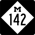
 Route Map of M-142 Route Map of M-142 |
| Notes: |
  M-142 is the "Trans-Thumb" state highway as it connects with M-25 on either side of Michigan's Thumb. The "Thumb" region is a portion of the state named as such because it is a peninsula jutting out on the side of the Lower Peninsula, or "the Mitten," which it is shaped like. From a touristic standpoint, the area is also often referred to as the "Blue Water Region." The three counties most commonly associated with being in the region are Huron—which M-142 traverses from west to east—Tuscola and Sanilac. Oftentimes, all or a portion of Lapeer and St Clair Cos are also included. The Thumb is a very flat region where agriculture has thrived due to conducive soils and lack of hilly terrain. Along the periphery is the shoreline of Lake Huron and Saginaw Bay, offering a diverse amount of recreational opportunities. M-142 is the "Trans-Thumb" state highway as it connects with M-25 on either side of Michigan's Thumb. The "Thumb" region is a portion of the state named as such because it is a peninsula jutting out on the side of the Lower Peninsula, or "the Mitten," which it is shaped like. From a touristic standpoint, the area is also often referred to as the "Blue Water Region." The three counties most commonly associated with being in the region are Huron—which M-142 traverses from west to east—Tuscola and Sanilac. Oftentimes, all or a portion of Lapeer and St Clair Cos are also included. The Thumb is a very flat region where agriculture has thrived due to conducive soils and lack of hilly terrain. Along the periphery is the shoreline of Lake Huron and Saginaw Bay, offering a diverse amount of recreational opportunities. |
| |
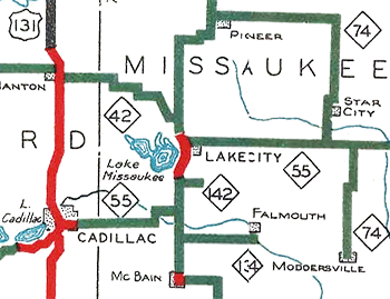
Huron County, at the "tip" of the Thumb region, features three main state trunkline routes: M-25 traces the Lake Huron and Saginaw Bay shoreline around the east, north and northwest sides of the county; M-53 runs directly up the middle from Detroit, ending at M-25 in Port Austin; while M-142 forms a "cross" with M-53 and runs east-west across the middle of the county. The two meet in the county seat of Bad Axe and actually run concurrently for 1½ miles heading northerly out of downtown Bad Axe. |
| |
 Historically, the first iteration of M-142 was as a short, mile-long spur trunkline route leading from M-55/M-66 just south of Lake City in Missaukee Co easterly to the Michigan State College Experimental Farm (present-day MSU Lake City Research Center) which, at the time, focused on agricultural experimentation in potato cultivation, in late 1929. Interestingly, while iternal State Highway Dept included the short spur highway route on internal maps, but it did not appear on publicly-issued highway maps until 1936. Just two years later, in the midst of a purge of many short highway spurs, the first M-142 is included and cancelled as a state trunkline route. However, within a year, the second iteration of M-142 debuts along the former route of M-83 across the Thumb from near Bay Port on the west through Bad Axe to Harbor Beach on the east—the precise route it occupies today. Historically, the first iteration of M-142 was as a short, mile-long spur trunkline route leading from M-55/M-66 just south of Lake City in Missaukee Co easterly to the Michigan State College Experimental Farm (present-day MSU Lake City Research Center) which, at the time, focused on agricultural experimentation in potato cultivation, in late 1929. Interestingly, while iternal State Highway Dept included the short spur highway route on internal maps, but it did not appear on publicly-issued highway maps until 1936. Just two years later, in the midst of a purge of many short highway spurs, the first M-142 is included and cancelled as a state trunkline route. However, within a year, the second iteration of M-142 debuts along the former route of M-83 across the Thumb from near Bay Port on the west through Bad Axe to Harbor Beach on the east—the precise route it occupies today. |
| |
In "State Trunkline Needs, 1960–1980," a set of maps prepared by the State Highway Dept's Office of Planning, Programming Division in 1960 showing possible additions, upgrades and improvements to the state trunkline system over the ensuing twenty years, MSHD staff showed the route of M-142 unchanged and exactly as it had been for its 21-year existence to that point—which it remains as to this day. |
| History: |
1929 (Dec 2) – A 1.0-mile long section of Jennings Rd from M-55/M-66/Morey Rd easterly to Call Rd just south of Lake City is established as a state trunkline and designated M-142. The only reason for the existence of this short stub of a highway to "nowhere" is that is serves the Michigan State College Experimental Farm (present-day MSU Lake City Research Center) located there and established the year prior. The new trunkline, which serves the so-called MSC Potato Farm, is referred to as "Potato Farm Rd." |
| |
1930 (Fall) – The State Highway Dept issues a contract worth $4,800 to surface M-142 in its entirety with a 12-foot wide course of gravel (which is rather narrow even by 1930 standards—modern-day highway lane widths are generally 11–12 feet, and this is 12 feet for the entire roadway!). |
| |
1936 – Although it was officially established as a state trunkline in late 1929, the State Highway Dept only adds M-142 south of Lake City to its official highway maps that are widely distributed to the public in 1936. (It has been depicted on internal Department maps since 1930.) |
| |
1938 (Dec 6) – Only eight years after becoming a state trunkline and on the same day 15.2 miles of other trunkline highway in Missaukee Co alone are cancelled, the 1.0 mile M-142 is cancelled as a state trunkline route and transferred to county control. A large volume of very short state highway spur routes as well as many others which don't rise to the level of deserving state highway status are cancelled and turned back to local control during this year. The first iteration of M-142 comes to an end after almost exactly nine years. |
| |
1939 (Jul 13) – The 5-mile section of M-83 via Bradleyville Rd through Gilford in western Tuscola Co is cancelled as a state trunkline and transferred to county control. Since this would have created a two-segment discontinuous M-83 route, all of that route north of M-81 (the portion not cancelled, as at Gilford) becomes parts of other routes. From north of Gilford to Unionville, the former M-83 becomes an extension of M-138, while the Unionville-to-Bay Port segment, formerly co-signed with M-25, retains the M-25 designation. The portion of former M-83 from M-25 just south of Bay Port easterly via Pigeon, Elkton and Bad Axe to US-25 at Harbor Beach is designated as M-142, thus beginning the second (and current) iteration of the designation. |
| |
1940 (Aug 12) – The State Highway Dept notifies the Huron Co Road Commission of the redesignation of M-83 from M-25 just south of Bay Port easterly via Pigeon, Elkton and Bad Axe to US-25 at Harbor Beach as M-142, even though the M-83 signs have not yet been replaced. It is assumed the M-142 route markers will be erected by the end of the year. |
| |
1951 (May 21, Oct 15) – When the State Highway Dept announces plans ot complete the hard-surfacing of M-142 by paving the highway from M-19/Carpenter Rd east of Bad Axe easterly to Verona Rd in the hamlet of Verona with asphalt instead of concrete, as originally intended, 23 landowners along that stretch which had granted the necessary right-of-way for the project—specifcically on the pretense the highway was going to be given a concrete surface—brought a lawsuit againt the Department objecting to the use of asphalt. Although codemnation proceedings were begun against those landowners, a settlement is reached on May 21 whereby the landowners would drop their objection and the State Highway Dept would be able to use the right-of-way needed to pave the section with asphalt. The paving is completed by October 15, which also completes the hard-surfacing on M-142 in its entirety. |
| Controlled Access: |
No portion of M-142 is freeway or expressway. |
| NHS: |
The portion of M-142 from the western terminus at M-25 to southern jct of M-53 in downtown Bad Axe is part of the National Highway System (NHS). |
| Memorial Highway: |
The following Memorial Highway designation has been officially assigned to part of M-142 shared with the route of M-52 by the Michigan Legislature:
- Earle Memorial Highway – "Highway M-53 extending from the city of Detroit north to M-25 in Huron County..." From MDOT: "Before a mile of Michigan roadway was paved or a centerline painted, before Henry Ford rolled his first Model A off the assembly line, there was Horatio 'Good Roads' Earle. At the turn of the century, this young entrepreneur and bicycle enthusiast was president of the League of American Wheelmen. This group, founded in 1880, fought for better roads and streets and the rights of bicyclists to use them. In 1892, they convinced the Michigan legislature to establish a state highway commission to recommend road improvements. Earle was a visionary; as early as 1901, he envisioned a system of roads that would connect every major city and every state capital. He founded the American Road Makers of 1902, which later became the American Road and Transportation Builders Association and lobbied for federal funding of road construction. Earle's zeal on behalf of the good-roads movement brought him national prominence and focused the attention of Michigan residents on the roads issue. In 1905, voters in 83 Michigan counties approved an amendment to the state's constitution authorizing state spending for roads, and creating the Michigan State Highway Department. The new department set up business in the office of the Speaker of the House in the State Capitol with an annual operating budget of $10,000 and a staff of five. Earle became the state's first highway commissioner."
|
| Photographs: |
|
| Weblinks: |
|