

Forest Highways
Contents: Forest Highway Route Listings | Forest Highways History | Additional Information
![]() Forest Highways (sometimes referred to as "Federal Forest Highways") are "forest roads under the jurisdiction of, and maintained by, a public authority and open to public travel." These highways are designated by the United States Forest Service (USFS) and funded by the federal government, but are often maintained by state or local agencies,
such as the Michigan Department of Transportation (MDOT) or the County Road Commissions in Michigan.
Forest Highways (sometimes referred to as "Federal Forest Highways") are "forest roads under the jurisdiction of, and maintained by, a public authority and open to public travel." These highways are designated by the United States Forest Service (USFS) and funded by the federal government, but are often maintained by state or local agencies,
such as the Michigan Department of Transportation (MDOT) or the County Road Commissions in Michigan.
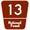 Nationwide, the Forest Highway system contains about 30,000 miles of roads and 4,214 bridges. States own and maintain 45% of these routes, counties another 48%, with the Forest Service itself owning and/or maintaining the rest. In order to qualify for federal funding under this system, a road must "be wholly or partially within, or adjacent to, and serving the National Forest System" and be nominated and selected as a federally-designated “Forest Highway” which also includes National Forest Scenic Byways. An example of the
Federal Forest Highway route marker appears at right. Examples of the various Forest Highway and Forest
Road signage can be found on the Route
Markers page.
Nationwide, the Forest Highway system contains about 30,000 miles of roads and 4,214 bridges. States own and maintain 45% of these routes, counties another 48%, with the Forest Service itself owning and/or maintaining the rest. In order to qualify for federal funding under this system, a road must "be wholly or partially within, or adjacent to, and serving the National Forest System" and be nominated and selected as a federally-designated “Forest Highway” which also includes National Forest Scenic Byways. An example of the
Federal Forest Highway route marker appears at right. Examples of the various Forest Highway and Forest
Road signage can be found on the Route
Markers page.
National Forests feature several types of numbered routes and roads, each one of them designated and signposted for inventory and navigational purposes. Types of numbered transportation facilities in National Forests include Forest Highways, Forest Roads, and Forest Trails, each providing for a different level of accessibility. Note that this website only attempts to catalogue the Forest Highways—those primary access routes providing all-weather access to all types of vehicles and that are oftentimes paved.
Forest Highways Route Listings
The various Federal Forest Highways are presented numerically by National Forest on the Route Listings page. Follow any the links below to jump directly to the National Forest of your choice:
Jump to: Hiawatha N.F. (East) | Hiawatha N.F. (West) | Huron N.F. | Manistee N.F. | Ottawa N.F.
Forest Highways History
The first federal funding for roads and trails serving National forests was provided by the 1916 Federal-Aid Road Act. The Federal-Aid Highway act of 1921 further divded forest roads and trails into two main classes: Forest Highways and Forest Development roads and trails. Forest Highways were defined as public roads owned by State or local agencies serving the National Forest System, while Forest Development roads were owned by the Forest Service itself. The designation of Forest Highways was done by the Federal Highway Administration's (FHWA) Federal Lands Highway Division enginers in consultation with State departments of transportation, local agencies, and the Forest Service.
A General Accounting Office (GAO) report in 1977 directed the FHWA and USFS to " jointly assure that transportation needs of the National Forest system were adequately considered when projects were being selected." Because of this, the Federal-Aid Highway Act of 1978 contained an amended definition of "Forest Highway." Further legal modification came in 1982 when the a federal statute (Public Law 97-424) provided for allocating Federal Highway funds according to the relative needs of the National Forest instead of simply apportioning those funds to the States. Federal funding apportionments were modified again in 1987 and 1991, in part directing the funds to be allocated by Forest Service Regions.
In 2012, however, the Forest Highways Program (FHP) was eliminated under "Moving Ahead for Progress in the 21st Century Act" (MAP-21), the federal funding legislation that replaced SAFETEA-LU which, along with ISTEA, had simply continued the program forward from previous funding legislation. Any Forest Highway project authorized under SAFETEA-LU and any funds carrying over from the previous legislation were to remain administered under the previous rules and regulations of the Forest Highways Program, however.
The replacement for the Forest Highway Program under MAP-21 is the Federal Lands Access Program (FLAP) which provides funds for projects on Federal Lands access transportation facilities located on, adjacent to, or providing access to Federal lands. A Federal Lands access transportation facility is defined as "a public highway, road, bridge, trail, or transit system that is located on, adjacent to, or provides access to Federal lands for which title or maintenance responsibility is vested in a State, county, town, township, tribal, municipal, or local government." FLAP is very similar to the FHP, except that instead of being targeted solely toward transportation facilities providing access to National Forests, the new program centers on facilities giving access to any Federal Lands, including lands managed by the National Park Service, the U.S. Forest Service, the U.S. Fish and Wildlife Service, the Bureau of Land Management, and the U.S. Army Corps of Engineers.
Additional Information
- Federal Lands Access Program – under which the funding to construct, maintain and upgrade designated roads providing access to, into and through various federal lands, including National Forests. This program replaced the former Forest Highways Program under the MAP-21 transportation funding legislation in 2012.
- Forest Highways Program (archived) – Until 2012, this program provided funding to resurface, restore, rehabilitate, or reconstruct designated public roads that provide access to or are within a National Forest or Grassland. It was superceeded by the FHWA's Federal Lands Access Program under MAP-21.
- Forest Lands Highway Program (FLHP) Fact Sheet (archived) – from the FHWA Office of Federal Lands Highway.
- Forest Highway Statewide Agreement ... for the Administration of the Forest Highway Program in the State of Michigan (archived) – an April 16, 1997 document from the Federal Highway Administration outlining the roles and responsibilities going forward from that date for the administration of Forest Highways in Michigan.
- National Forests in Michigan – the four national forests in the state are:
- Hiawatha National Forest – two units in the eastern half of the Upper Peninsula
- Huron-Manistee National Forests – two forests managed jointly in the western (Manistee) and northeastern (Huron) portions of the Lower Peninsula.
- Ottawa National Forest – situated in the western third of the Upper Peninsula.