

| Back to Previous Route: M-54 |
 |
On to Next Route: M-56 |
| Western Terminus: | US-31 two miles northeast of Manistee (cnr Chippewa Hwy & Caberfae Hwy) |
| Eastern Terminus: | US-23 in downtown Tawas City (cnr of Hemlock Rd & Lake St) |
| Length: | 150.973 miles |
| Maps: | Route Map of M-55 Houghton & Higgins Lakes Area Trunkline History Map, 1939-Present |
| Notes: | One of only three cross-peninsular state (M-numbered) highways in the Lower Peninsula. The other two are M-46 (Muskegon-to-Port Sanilac) and M-72 (Empire-to-Harrisville). In addition, M-55 is often used as a convenient "dividing line" in the Lower Peninsula (eg. separating firearm/bow hunting zones, etc). |
| Along its course, M-55 crosses the magnificent Cooley Bridge over the Manistee River east of Wellston. The following excerpt was taken from the book "Historic Highway Bridges of Michigan" by Charles K Hyde (1993, Wayne State University Press, ISBN 978-0814324486): M-55 Mortimer E. Cooley Bridge (1935) over the Pine River, 21 miles east of Manistee, Manistee County, Deck Truss, Cantilevered. The State Highway Department designed this bridge, named in honor of Mortimer E. Cooley, dean of the College of Engineering at the University of Michigan from 1904 to 1928. The Cooley Bridge, with its total length of 555 feet, is notable on aesthetic grounds as well; it won the American Institute of Steel Construction Award for the most beautiful structure in its class built during 1935. More information and a photo of the bridge at MDOT's website. |
|
"The Houghton Lake Area Tourism Bureau reached out to Michigan Department of Transportation (MDOT) with a desire to create an M-55 Recreational Scenic Byway Route that crosses the state of Michigan from Manistee County to Iosco County, a designation that would highlight the diverse recreational opportunities and unique characteristics that could attract more visitors to a Michigan coast-to-coast trunkline. Supporting points of interest were highlighted along the M-55 corridor in Roscommon County and outward towards both Manistee and Tawas. This designation will help protect regional attributes, views, and pastoral land use. It will provide funding opportunities for new and existing improvements to infrastructure, protection of special assets and resources, and provide marketing opportunities to attract visitors and encourage economic growth to the area." |
|
In "State Trunkline Needs, 1960–1980," a set of maps prepared by the State Highway Dept's Office of Planning, Programming Division in 1960 showing possible additions, upgrades and improvements to the state trunkline system over the ensuing twenty years, MSHD staff recommended many changes to M-55 during that timeframe, including:
|
|
| History: | 1915 (Dec 4) – A 2.5-mile segment of state trunkline highway along the southern shore of Lake Cadillac in the City of Cadillac is established as a state trunkline highway route as T.L. 55 (later signed as M-55), along Sunnyside Dr from 41 Rd westerly to the western city limit of Cadillac. |
| 1916 (July 18) – 14.2 miles of state trunkline highway are established as T.L. 55 (later M-55) in Roscommon and Missaukee Cos from Houghton Lake, westerly. From the northern end of a realignment for T.L. 14 (later M-14, then US-27)—established on the same day—at the corner of Loxley Rd & Federal Ave-Calkins Rd south of Houghton Lake Heights in Roscommon Co, the first segment of T.L. 55 (later M-55) continues north via Loxley Rd to Heightsview Dr, westerly via Heightsview Dr to present-day M-55, then westerly via present-day M-55 into Missaukee Co to existing T.L. 14/Merritt Rd (later M-74) at Merritt and from T.L. 14/Star City Rd (later M-74) westerly to Seven Mile Rd at Keelans Corners. A second segment is established running from T.L. 14/Star City Rd (later M-74) westerly to Seven Mile Rd at Keelans Corners. (The 2 mile segment between Merritt Rd and Star City Rd had been part of T.L. 14 [later M-74] for two years.) | |
| 1919 (July 1) – T.L. 55 is signed in the field as M-55 as all state trunkline highways in Michigan are signed with route markers. | |
| 1919 (Aug 26) – A 21.2-mile segment of M-55 connects the "dangling end" of the existing M-55 at Keelans Corners in central Missaukee Co with the City of Cadillac in Wexford Co. Beginning at the western end of M-55 at Seven Mile Rd in Missaukee Co, the new trunkline route is established continuing due west to present-day M-66 at Lake City, turns southerly through downtown Lake City via Main St and Morey Rd to Blue Rd, west two miles on Blue Rd, southerly for a mile via Dickerson Rd, and westerly via Cadillac Rd (Missaukee Co) and E Division St (Wexford Co) to a new terminus at the eastern city limit of Cadillac at Crosby Rd. | |
| 1920 (Aug 10) – The state jurisdiction of M-55 is extended further into the City of Cadillac. From the west, segments of Sunnyside Dr (41 Rd to Granite St), Granite St (Sunnyside Dr to Mitchell St), and Mitchell St (Granite St to Howard St) are officially established as state trunkline highway routes (with the Mitchell St segment concurrently signed with M-13, later US-131, now BUS US-131). On the east, E Division St from Crosby Rd to Harris St and Harris St from E Division St to Shelby St is likewise established as a state trunkline highway route as part of M-55. It is asumed this segment of roadway has been signed as part of M-55, but is now officially under the jurisdiction of the State Highway Dept. | |
| 1923 (Apr 4) – An additional 6.2 miles of M-55 are established on the south shore of Houghton Lake in Roscommon Co, beginning at M-14 (later US-27) the corner of Loxley Rd & Federal Ave-Calkins Rd south of Houghton Lake Heights, continuing easterly via Federal Ave and then the present-day route of M-55 via Houghton Lake Dr to M-18 in downtown Prudenville. | |
| 1925 (Sept 1) – M-55 is extended for approximately one mile from Prudenville northeasterly concurrently with M-18. From that point, 11.7 miles of new state trunkline highway route is established from M-18 northeast of Prudenville due easterly via West Branch Rd to M-76 south of Saint Helens. M-55 is then extended concurrently with M-76 to the east into Ogemaw Co into West Branch. On this same day, the route of M-76 between West Branch in Ogemaw Co and Sterling in Arenac Co is drastically altered. This results in the M-55 designation being extended easterly along the former route of M-76 from West Branch to Prescott. From Prescott, M-55 is extended easterly supplanting the route of M-70 via Greenwood Rd ½ mile, northly along Black Rd for a mile, jogging easterly on Craun Rd, then continuing northeasterly and northerly via Black Rd, turning easterly to run along Mills Rd (Ogemaw Co) and Prescott Rd (Iosco Co), terminating at M-10 (later US-23, now M-65) at Whittemore. | |
| 1927 (June 30) – A new 4.4-mile alignment for M-55/M-76 in eastern Roscommon and western Ogemaw Cos, beginning at the western jct of the two routes and continuing southeasterly, is established as a state trunkline highway route on this date, although State Highway Dept records state this same route was surfaced and open for traffic in 1925. The former 4.8-mile trunkline alignment—which may have never been physically constructed—is turned back to local control or, in the case of a never-built alignment, simply cancelled as a trunkline route. | |
| 1927 (late-Aug) |
|
| 1928 (May 7) – The route of M-55/M-66 through Lake City from the northern jct of M-55 & M-66 on the north edge of town southerly to Jennings Rd is simultaneously cancelled (removed from the state trunkline highway system) and established (added to the system) on this day. This is likely due to multiple minor adjustments to the route of the highway. | |
| 1929 (Oct 1) – M-55 is realigned in eastern Ogemaw and western Iosco Cos. From the intersection of Clark Rd & Tawas Rd, M-55 now runs due easterly via Tawas Rd along 7.1 miles of newly-established trunkline route to end at US-23, three miles north of Whittemore (present-day jct of M-55 & M-65). Approximately 8 miles are shaved from the route length. The former portion of M-55 southerly into Prescott via Clark and Harrison Rds becomes an extension of M-70, while the remainder between Prescott and Whittemore is turned back to county control. | |
1931–1933
|
|
| 1932 (Aug 6) – The route of M-55 is extended on the east by 14.5 miles along a leg of the former US-23 from present-day M-65 to end in downtown Tawas City. At this time, M-55 runs roughly along its present-day routing between its present-day termini. | |
| 1935 (Jan 7) – A 2.0-mile segment of new alignment M-55 is established running directly between Federal Ave and Loxley Rd at Houghton Lake Heights in Roscommon Co. The former route along Federal Ave retains the US-27 designation, while the Loxley Rd alignment from US-27/Federal Ave-Calkins Rd northerly to M-55 is retained as a state trunkline highway, likely signed as a US-27/M-55 connector route. | |
| 1935 (Oct 28) – The magnificent Mortimer E. Cooley Bridge over the Pine River east of Wellston is completed and opened to traffic. The 0.79 miles of highway that comprises the bridge and its approaches is officially added to the state trunkline system on this day. See note above for more information. | |
| 1936 (Feb 6) – A 0.47-mile segment of M-55 is established as a state trunkline route from the eastern end of the 1931 segment (see above) at the Cadillac Country Club continuing easterly to approximately the western city limit of Cadillac. (This segment had been paved during 1935 and it is unclear why it was added four years after the segment immediately to the west.) | |
| 1938 (Dec 6, Dec 22) – On December 6, the 14.4-mile segment of M-55 running along 1st St and State St in West Branch then easterly via State Rd through Selkirk and then southerly along Henderson Lake Rd to Tawas Rd is turned back to local control, even though the replacement for that segment—directly east from M-76 at West Branch for 11.0 miles via Tawas Rd to Henderson Lake Rd—is not officially assumed into the state trunkline system for another 16 days. On December 22, the 11.0 mile portion of Tawas Rd from M-76 at West Branch then easterly is officially established as a trunkline route as part of a relocated M-55. This rerouting shortens the course of M-55 by 4½ miles. | |
| 1942 (Jan 28) – The 1.5-mile former alignment of M-55 along Loxley Rd between US-27/Federal Ave and M-55/Heightsview Dr in Houghton Lake Heights bypassed by a new alignment in 1935 (and likely signed as a US-27/M-55 cut-off/connector) is turned back to local control. (See Houghton & Higgins Lakes Area Trunkline History Map, 1939-Present.) | |
| 1945 (June 26) – M-55 is rerouted in downtown Cadillac. The former route, following Harris St from US-131/Mitchell St northeasterly to Division St and Division St easterly to Cass St is turned back to city control, while the portion of Cass St from US-131/Mitchell St northeasterly to Division St is established as a state trunkline routing. The route of M-55 is now approximately one city block shorter, as eastbound traffic now turns east off Mitchell St one block sooner at Cass instead of at Harris. | |
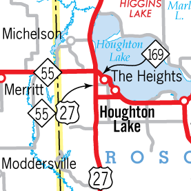 1949 (July 3) – A major realignment of US-27 to the west of Houghton and Higgins Lakes removes the concurrent US-27/M-55 designation from M-55 between Houghton Lake Heights and Prudenville. Approaching the Houghton Lake area from the east, M-55 now turns southerly to run concurrently with the new US-27 (formerly M-169) for two miles, then easterly via the former US-27 (via Federal Ave) into the community of Houghton Lake. The former alignment of M-55 through Houghton Lake Heights is designated as M-169, which, for the previous seven years, had run along the 2.1-mile segment of the US-27 Houghton-Higgins Lake bypass (opened to through traffic on this date) from Houghton Lake Dr to Federal Ave. 1949 (July 3) – A major realignment of US-27 to the west of Houghton and Higgins Lakes removes the concurrent US-27/M-55 designation from M-55 between Houghton Lake Heights and Prudenville. Approaching the Houghton Lake area from the east, M-55 now turns southerly to run concurrently with the new US-27 (formerly M-169) for two miles, then easterly via the former US-27 (via Federal Ave) into the community of Houghton Lake. The former alignment of M-55 through Houghton Lake Heights is designated as M-169, which, for the previous seven years, had run along the 2.1-mile segment of the US-27 Houghton-Higgins Lake bypass (opened to through traffic on this date) from Houghton Lake Dr to Federal Ave. |
|
| 1950 – By the end of the year, the newly relocated M-169 (formerly the routing of M-55 until early July 1949) in the area of Houghton Lake Heights in Roscommon Co is redesignated as BUS M-55. | |
| 1950 (Nov 3) – A new routing for M-55 is officially established as a state trunkline highway from the area of N 5th Ave-Wilber Rd at the northern limit of the City of Tawas City and continuing southeasterly via Hemlock Rd to a new terminus at US-23 northeast of downtown Tawas City. The former route via Nunn Rd from Hemlock Rd to Bridge St in East Tawas, then southeasterly via Bridge St, easterly via State St, and finally southerly via Newman St to US-23 in downtown East Tawas remains on the state trunkline system for another eight months. | |
| 1951 (July 2) – The former route of M-55 at Tawas City and East Tawas bypassed by the new Hemlock St routing established as a state trunkline highway on November 3, 1950 is oficially turned back to city and county control. | |
| 1958 (Sept 16) – M-55 and M-115 are realigned at their northwestern jct on the west side of Cadillac. Until now, M-115 ran via Sunnyside Dr (western portion—not the segment running east of M-115 along the south shore of Lake Cadillac) to South Lake Mitchell Dr, then curved notherly along South Lake Mitchell Dr to its crossing over the channel linking Lakes Cadillac and Mitchell. M-55 followed Sunnyside Dr to South Lake Mitchell Dr, then turned southwesterly via South Lake Mitchell Dr. The new M-115 alignment bypasses the sharp curve on South Lake Mitchell Dr while the new M-55 alignment preserves the 90° junction with M-115. The former routes are turned back to local control except the portion through William Mitchell State Park which is oblitered and becomes part of the swimming beach day-use area. | |
| 1959 – The final several miles of unpaved M-55 are hard-surfaced, in central Iosco Co. | |
| 1960 (May 28, July 22) – M-55 is rerouted in Roscommon Co to bypass the community of Houghton Lake Heights on a new alignment between the two intersections of Heightsview Dr and Houghton Lake Dr and opens to traffic on May 28. Additionally, the sharp turn immediately east of the US-27 (now Old 27) jct is bypassed by a more gentle, sweeping curve. Both bypassed segments of M-55 are turned back to county control on July 22. | |
| 1961 (Dec 4) – With the completion of the US-27 freeway, the M-55 routing is restored to its former alignment via BUS M-55 through Houghton Lake Heights, which it replaces. The former route of M-55 along (Old) US-27 and Calkins Rd-Federal Ave is turned back to county control. | |
| 1970 – With the completion of another portion of the M-76 freeway around West Branch, the formerly-concurrent portion of M-55/M-76 through downtown West Branch becomes M-55/BUS M-76. | |
| 1973 – With the final segment complete, the M-76 freeway is designated as the final link of I-75 in Michigan. Between the Maple Valley and West Branch areas, the M-55 routing is transferred onto the newly opened I-75 while the old route becomes an unsigned state trunkline as "OLD M-55." BUS M-76 through West Branch becomes BL I-75. | |
| 1974 (Nov 15) – A new, more direct alignment for M-55 along Watergate Rd from the Wexford/Missaukee Co line easterly to Blue Rd approximately ½-mile east of Dickerson Rd is established as a state trunkline highway. The new alignment, which may have opened to traffic earlier in the year, shaves approximately one mile from the former route along Cadillac Rd (from the county line easterly to Dickerson Rd), Dickerson Rd (Cadillac Rd–Blue Rd), and Blue Rd (Dickerson Rd easterly ½-mile), which remains as an unsigned state trunkline as OLD M-55. | |
| 1980 (Feb 26) – The former route of M-55 in southwestern Misaukee Co along Cadillac, Dickerson and Blue Rds which had been bypassed by a newly-constructed alignment in 1974 is turned back to county control. OLD M-55 is cancelled as a state trunkline highway route. | |
| 2000 (Nov 1) – The first 2.9 miles of the "Cadillac Bypass" opens to traffic and while that freeway would eventually bear the US-131 designation, for the next year, it will only be signed as a rerouted M-55. From the north end of the opened freeway about 1.5 miles east of downtown Cadillac, M-55 now turns southwesterly via the new freeway (joining with US-131 at Exit 177) to M-115 at Exit 176, then runs concurrently with M-115 northwesterly back to the former route of M-55 in the "Lakes Area" on the west side of Cadillac. The former portions of M-55 along E Division St, E Cass St, Granite St and Sunnyside Dr becomes an unsigned state trunkline designated OLD M-55. The formerly concurrent US-131/M-55 via Mitchell St in downtown Cadillac between Granine St and E Cass St remains only US-131. | |
| 2001 (Oct 30) – The remainder of the US-131 "Cadillac Bypass" is opened to traffic on this day from the M-55 EAST interchange (Exit 180) northerly to existing US-131 north of Cadillac. US-131 now officially joins M-55 on the portion of the freeway opened November 1, 2000 between Exits 177 and 180. | |
| 2003 (Dec 4) |
|
| 2018 (Aug 15) |
|
| 2023 (Oct) |
|
| Controlled Access: | Two segments of M-50 exist as freeway:
|
| Expressway: No portion of M-55 is expressway. | |
| NHS: | Two segments of M-55 are on the National Highway System (NHS): |
| Pure Michigan Byway: | |
| Memorial Highways: | The following Memorial Highway designation has been officially assigned to a part of M-55 by the Michigan Legislature:
|
| Photographs: | |
| Weblinks: |
|
| Back to M-54 | Route Listings Home | On to M-56 |