

| Back to Previous Route: Former M-114 |
 |
On to Next Route: M-116 |
| Western Terminus: | M-22 on the east side of Frankfort (cnr Forest Ave & Lake St) |
| Eastern Terminus: | Downtown Clare at jct BUS US-127 & BUS US-10 (cnr Fifth St & McEwan St) |
| Length: | 96.712 miles |
| Maps: | Route Map of M-115 |
| Notes: | Even though M-115 is signed as an east-west highway, it actually works primarily to ferrry tourist traffic from southern areas to the North Country (and back), although it is essentially a northwest-southeast route. |
| M-115 is a major tourist route between the southern Lower Peninsula and torthwest Michigan, including the popular Grand Traverse Region. Because of the high traffic volumes along this highway, many improvements have taken place over the years, including the addition of several miles of passing lanes, a roundabout at the eastern jct of M-37 at Mesick and an improved intersection at jct M-66 south of Marion. As traffic increases, additional passing lanes and other upgrades will likely continue to take place. | |
| In the mid-1930s, the Michigan State Highway Dept began an effort to construct "diagonal highways" between major destinations: the "Chicago–Montreal Highway," the "Holland–Toledo Diagonal," and the "Detroit– or Clare–Frankfort Diagonal." The last of these included US-10 from Detroit through Flint, Saginaw, and Midland to Clare and Farwell, then proceeded along a newly-designated alignment not yet constructed between Farwell and Benzonia before assuming the existing short connector route of M-115 between Benzonia and Frankfort. Interestingly, only the M-115 "Detroit–Frankfort or Clare–Frankfort Diagonal" was ever completed. See Diagonal Highways, 1935–36 for full details and a map of the various routes. | |
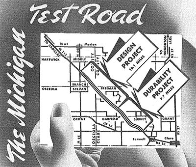 In the early 1940s, an 18-mile portion of M-115 northwest of Farwell was known as the Test Road when the State Highway Dept incorporated new designed and durability principles in highway construction as part of a five-year traffic test. This experimental project was reported as "the most extensive in American highway construction history" and was the first since the 1922 Bates Road Tests in Illinois. The project was begun in May 1940, announced in May of that year and the segment of highway was opened to traffic in December. The specifications for this new portion of highway included all the latest highway testing, research and soil engineering principles having recently passed labratory tests. One 1,800-foot stretch used a "stress curing" principle which eliminated steel mesh reinforcement, which made it possible to lay concrete in slabs of 100 feet instead of 30 feet, as was the norm at the time. In other areas, the concrete slabs were laid in 10- and 20-foot sections and their thicknesses were varied as well. New materials were also used in constructing the highway, including the use of extra-fine sand, and a soapy material called orvus which, along with vinsol resin, was hoped to help resist the surface-scaling action of road salt used in the winter to melt snow and ice. Normal vehicular traffic using M-115 was to help test these new principles in a real life sitaution. In the early 1940s, an 18-mile portion of M-115 northwest of Farwell was known as the Test Road when the State Highway Dept incorporated new designed and durability principles in highway construction as part of a five-year traffic test. This experimental project was reported as "the most extensive in American highway construction history" and was the first since the 1922 Bates Road Tests in Illinois. The project was begun in May 1940, announced in May of that year and the segment of highway was opened to traffic in December. The specifications for this new portion of highway included all the latest highway testing, research and soil engineering principles having recently passed labratory tests. One 1,800-foot stretch used a "stress curing" principle which eliminated steel mesh reinforcement, which made it possible to lay concrete in slabs of 100 feet instead of 30 feet, as was the norm at the time. In other areas, the concrete slabs were laid in 10- and 20-foot sections and their thicknesses were varied as well. New materials were also used in constructing the highway, including the use of extra-fine sand, and a soapy material called orvus which, along with vinsol resin, was hoped to help resist the surface-scaling action of road salt used in the winter to melt snow and ice. Normal vehicular traffic using M-115 was to help test these new principles in a real life sitaution.Once open, State Highway Dept and Bureau of Public Roads (modern day FHWA) engineers planned to constantly monitor the pavement's moisture content, temperature under changing traffic and weather conditions, expansion and contraction, flexibility, and the sinking and rising of the roadway over time. Even though the one-year anniversary of the completion of the Test Road coincided with the Attack on Pearl Harbor and the official US entry into World War II, the monitoring and testing planned for this segment continued through the War. There were actually two segments of the Test Road: the Design Project (10.1 miles from Lake Station Ave in Clare Co to M-66 in Osceola Co), which saw a major report released in September 1941 and the Durability Project (7.7 miles from US-10 northwest of Farwell to Lake Station Ave in Clare Co), which didn't see its final results until January 1960, after the segment had been resurfaced with asphalt in 1957 and any future testing was rendered moot.
|
|
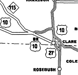 Unfortunately, when MDOT decided to relocate M-115 as a restored signed state trunkline designation along the unsigned route from the US-10 & M-115 junction through Farwell to downtown Clare (internally designated within MDOT as "OLD US-10"), one or more MDOT-issued maps erroneously labeled this route as BUS US-10, not M-115 (see map snippet at right from a 1999 MDOT state trunkline map). Nearly all commercially-produced roadmaps and road atlases since that time showed the route through Farwell to Clare as BUS US-10, when it has been signed as M-115 since 1989. In more modern times, eventually Google Maps corrected this route from being shown as BUS US-10 to M-115, but at last check in the mid-2020s, Bing Maps still showed BUS US-10 along with M-115 on that route and included "BUS US-10" in its textual, turn-by-turn directions. Apple Maps seems to have gotten the designation correct, however. In addition, between 1989 and 2002, the Official Transportation Map issued by MDOT showed no route designation on the segment in question, while in 2003 when the road map was first digitized, an M-115 symbol was added. Unfortunately, when MDOT decided to relocate M-115 as a restored signed state trunkline designation along the unsigned route from the US-10 & M-115 junction through Farwell to downtown Clare (internally designated within MDOT as "OLD US-10"), one or more MDOT-issued maps erroneously labeled this route as BUS US-10, not M-115 (see map snippet at right from a 1999 MDOT state trunkline map). Nearly all commercially-produced roadmaps and road atlases since that time showed the route through Farwell to Clare as BUS US-10, when it has been signed as M-115 since 1989. In more modern times, eventually Google Maps corrected this route from being shown as BUS US-10 to M-115, but at last check in the mid-2020s, Bing Maps still showed BUS US-10 along with M-115 on that route and included "BUS US-10" in its textual, turn-by-turn directions. Apple Maps seems to have gotten the designation correct, however. In addition, between 1989 and 2002, the Official Transportation Map issued by MDOT showed no route designation on the segment in question, while in 2003 when the road map was first digitized, an M-115 symbol was added. |
|
In "State Trunkline Needs, 1960–1980," a set of maps prepared by the State Highway Dept's Office of Planning, Programming Division in 1960 showing possible additions, upgrades and improvements to the state trunkline system over the ensuing twenty years, MSHD staff recommended absolutely zero changes to the route of M-115 during that timeframe. In 1960, M-115 ran from M-22 in Frankfort to US-10 northwest of Farwell and the planning maps only indicated the following potential impacts to the route of M-115:
|
|
| History: | 1927 (June 13) – A delegation of Benzie Co businessmen, mostly from Frankfort, attend the State Administrative Board meeting in the Governor's office and request a state trunkline highway be designated connecting M-22 at Frankfort with US-31 (newly redesignated from M-11) at Benzonia. The local representatives contend the new highway route would greatly help with wintertime access into Frankfort, which has been an issue. Additionally, a million dollar planned improvement to the Frankfort harbor to facilitate a more direct connection to the carferries will only bring more automobile traffic to the area, which the Frankfort–Benzonia highway would help handle. State Highway Commissioner Fred F. Rogers felt there was value in the proposal and that there were three possible routes the highway could take. |
| 1928 (Oct 1) – Although not officially established as a state trunkline highway for a year and a half, M-115 shows up on official State Highway Dept planning maps as a short connecting route between M-22 at Frankfort and US-31 at Benzonia. | |
| 1929 (May) – M-115 debuts on the official State Highway Dept maps distrubutes to the public, signifying the route is presumably signed on the ground at this point, most likely as a Signed & Maintained route, pending its official transfer to state control. | |
| 1930 (Mar 31) – The 6.4-mile long route of M-115 linking Frankfort with Benzonia is transferred to state jurisdiction. However, official maps through 1935 show M-115 as running via Grace Rd between US-31 south of Benzonia and M-22 south of Elberta because final construction on the direct Frankfort-Benzonia route is not yet complete. | |
| 1933 (Sept 1) – Federal approval is granted for 113 highway projects across the state, including for a 7-mile long project calling for 21-foot wide surfacing along M-115 between Frankfort and Benzonia in Benzie Co, costing $55,000. Actual work is likely completed on this project by the end of the construction season. | |
| 1935 (Jan 7) – A new state trunkline, 58.8 miles all on new alignment in Wexford, Osceola and Clare Cos, is officially established beginning at M-42 (present-day M-37) on the east side of Mesick and proceeding southeasterly past Cadiilac, through northeastern Osceola Co and ending in downtown Farwell at US-10. The only construction completed on the new route is the short portion from US-10 (present-day Surrey Dr) northwest of Farwell to the cnr of Corning & Main Sts in downtown Farwell. | |
| 1935 (Jan 14) – Bids are opened to pave 13.2 miles of M-115 from M-66 south of Marion northwesterly to the Osceola/Wexford Co line with 20-foot concrete costing almost $330,000. An additional bid is opened to continue the 20-foot concrete paving from there northwesterly into Wexford Co to US-131/Mackinac Trail an additional 3.6 miles for $90,000. Construction is to be complete by fall. | |
| 1935 (July 26) – Bids are opened to complete paving on the final 4.313 miles of unsurfaced M-115 between Frakfort and Benzonia in Benzie Co using 20-foot bituminous concrete costing almost $79,000. Construction is expected to be complete by fall and the highway to be finally opened to traffic permanently at that time. | |
1936 – Work on the following four segments of M-115 is completed this year:
|
|
| 1937 (Aug 30) – The 5.4-mile portion of M-115 completed in 1936 from Mesick westerly to the Wexford/Manistee Co line is officially established as a state trunkline, while construction northwesterly from that segment, from the Wexford/Manistee Co line to west of Copemish—itself not yet officially a trunkline!—commences. |
|
| 1937 – The remaining portion of M-115 between US-131 and M-66 to be finished—from M-61/20 Mile Rd west of Marion to M-66/30th Ave south of Marion in Oseola Co—is completed with 20-foot-wide pavement. M-115 is now complete and paved from US-131 south of Cadillac to M-66 south of Marion. |
|
| 1938 (Sept 6) – Nearly 200 Works Progress Administration (WPA) workers currently employed on the construction of M-115 in northern Manistee Co near Copemish go on strike, protesting a new way of computing working hours. | |
| 1938 – By early 1938, M-115 from the Manistee/Wexford Co line westerly to west of Copemish (still not yet officially designated a trunkline) is opened to traffic as a "graded-earth" roadway. | |
| 1939 – The portions of M-115 from US-31 south of Benzonia to west of Copemish and from M-66 south of Marion to Lake Station Ave in western Clare Co are completed as "graded-earth" roadway by the Works Progress Administration, meaning the highway now exists, in some form, as a two-segment, discontinuous route: From Frankfort to Mesick, and from M-55 (Cadillac) to US-10 (Farwell). Also, grading and drainage structures on 5.64 miles of M-115 in Clare Co from Lake Station Ave five miles north of the community of Lake northwesterly to the Osceola Co line are completed, bringing the graded-earth segment of highway from US-10 northwest of Farwell to 13.32 miles in length. It's unlcear if the route is signed as M-115, though, since the remainder of the highway to M-66 is not yet complete and open to traffic. |
|
| 1940 (July 3) – Bids are opened to complete paving on the 7.78 miles of unsurfaced M-115 between US-10 northwest of Farwell and Lake Station Ave in Clare Co using 22-foot wide concrete costing nearly $200,000. The grading and drainage structures were completed on this segment in 1936. This is the "Durability Project" portion of The Michigan Test Road. | |
| 1940 (Dec 6) – M-115 between M-66 and US-10 is completed as a concrete-surfaced highway, although that portion had been opened to traffic as an earth-surfaced highway since 1936 and 1939. This segment is The Michigan Test Road, with the last 10.15 miles to the completed being the "Design Project" project from Lake Station Ave in Clare Co to M-66 in Osceola Co, costing $231,565 and featuirng a 22-foot wide concrete pavement. Overall The Test Road was nearly 18 miles in length. | |
| 1941 (Nov 7) – Opening ceremonies are held for M-115 in Frankfort with State Highway Commissioner Donald G Kennedy cutting a ribbon to officially open the highway. Kennedy later speaks at a celebratory banquet. | |
| 1942 (Jan 28) – Even though it had been open to traffic as a "graded-earth" roadway since 1938–39, the 18.6 miles of M-115 from US-31 south of Benzonia to the Manistee/Wexford Co line is officially transferred to the state trunkline system. Also, that same segment of roadway is surfaced with gravel in 1942. | |
| 1942 (July 9) – Bids are opened on a project first announced in March 1941 to add a 21-foot stabilized aggregate surface along the 9.75 miles of M-115 in its entirety in Manistee Co from the Benzie Co line west of Thompsonville to the Wexford Co line betwee Copemish and Mesick. The final project extends the limits for a total of 18.1 miles into Benzie Co to US-31 south ot Benzonia for a total of $37,430. | |
| 1947 (July 25) – The contract to apply a non-skid hard-surfacing to the 23.5 miles of M-115 between US-31 south of Benzonia in Benzie Co and M-37 at Mesick in northwesterly Wexford Co is let for $18,933, with completion anticipated by the end of the construction season. This results in the last section of gravel-surfaced M-115 (that is currently complete and open to traffic) becoming hard surfaced. | |
| 1948 (Dec 10) – An overloaded truck hits and demolishes an old, high-truss bridge on M-115 spanning the Manistee River on the western edge of Mesick in Wexford Co. A lengthy detour is put into place around the demolished bridge until a temporary span can be erected. | |
| 1949 (Feb 3—Oct 6) – A temporary span over the Manistee River at Mesick is put in place on Feb 3 while State Highway Dept engineers design a new bridge with three 60-foot spans with construction to begin in the spring. The replacement structure is finally completed and opened to traffic on Oct 6. | |
| 1951 (Dec 19) – Even though a state trunkline route for M-115 was officially established between Mesick and Cadillac in Wexford Co in early 1935, the highway itself between those communities was never constructed. By the 1950s, State Highway Dept planners elect to find a new alignment for M-115 between Mesick and Cadillac. The first 6.377 miles of new M-115 alignment are established from Mesick southeasterly on this date from Clark St on the east limit of Mesick to Elm Flats Rd. Actual construction on this segment began in early February 1950 and a gravel-surfaced roadway is completed around this time as well. At this point, however, M-115 is not signed along this segment of highway. This is the first step in finally bridging the gap in M-115 between Mesick and Cadillac. | |
| 1953 (Apr 23) – A contract for 8.523 miles of aggregate surface on M-115 between Elm Flats Rd and Boon Rd (34 Rd) in central Wexford Co is let for just over $109,000. This is the second step in completing the Mesick-to-Cadillac discontinuity. Maps begin showing an unpaved local road between Mesick and Boon Rd northwest of Cadillac at this point, which likely translates into M-115 not being signed along this segment of roadway at this time. | |
| 1957 – The roadway between M-37 at Mesick and Boon Rd (34 Rd) northwest of Cadillac in central Wexford Co, noted above, is now assumedly signed as M-115 in the field as it is designated as such on official 1957 highway maps. An interesting route change also takes place at Cadillac, albeit a temporary one. From the southeast, M-115 is rerouted from its jct with US-131 south of Cadillac to run concurrently via US-131 northerly through downtown Cadillac to Boon Rd (34 Rd) north of town, then westerly via Boon Rd (34 Rd) to the 1953-era Cadillac-Mesick road, then northwesterly to Mesick. It is unclear if the section of M-115 between US-131 south of Cadillac and M-55 west of Cadillac remains signed as part of M-115 or is "de-signed" for the time being. The portion of what will eventually become M-115 from M-55 to Boon Rd (34 Rd) is still under construction. | |
| 1958 (Sept 16) – In a largely administrative move, the portion of M-115 between Cadillac and Mesick in Wexford Co is cancelled and established as a state trunkline highway route today. The originally-proposed route from the eastern limits of Mesick southeasterly to the northern end of the Lake Cadillac causeway in western Cadillac is cancelled as a state trunkline route. The segment of M-115 from the Osceola Co line northwesterly to Mesick was originally established as a trunkline route on July 1, 1935, but only the portion from the Osceola Co line to the Lake Cadillac causeway was constructed on its originally-proposed alignment. From the north end of the causeway northwesterly to Mesick, the 1935 route lay unbuilt and dormant until the 1950s when the effort to complete M-115 and join the two disconnected segments began again in earnest. As the segment from the eastern limits of Mesick southeasterly to Elm Flats Rd had been established back in 1951, this establishment only runs from Elm Flats Rd southeasterly to the north end of the Lake Cadillac causeway at Cadillac. Not only is the segment of M-115 from Elm Valley Rd in Antioch Twp to Lake Cadillac in Cadillac now officially a state trunkline route, construction on that portion is also completed and opened to traffic around this time as well. M-115 is now, finally, a single, continuous drivable route from Farwell near Clare to Frankfort on Lake Michigan. If the M-115 markers had been removed from the US-131–to–M-55/Sunnyside Dr segment southwest of Cadillac in 1957, they are restored now as that segment now leads into the newly-completed highway between there and Elm Flats Rd. The M-115 markers along the temporarily-signed route of M-115 north through Cadillac via US-131 then westerly along Boon Rd (34 Rd). Boon Rd (34 Rd) from US-131/Mackinac Trl to M-115/Cadillac Hwy never was officially established as a state trunkline highway route as this segment was only Marked-and-Maintained as part of M-115. |
|
| c.1963 |
|
| 1965 (Spring) – The "Marine Gateway," the distinctive gateway spanning M-115 at the top of the hill overlooking Frankfort to the west welcoming motorists entering the city from the east and featuring a model of the Ann Arbor Railroad carferries which connect the city to ports across Lake Michigan, is dismantled to accommodate widening of the highway and is to be reconstructed. The pillars of the gateway, built of stone, are located too close to highway traffic and deemed a hazard to motorists. | |
| 1967 (May) – The reconstructed "Marine Gateway," now with a horizontal clearance of 64 feet and vertical clearance of 20 feet, is completed. The new structure, in addition to the wider clearance, is built from structural steel and clad in sheet metal, and features an updated model of the Ann Arbor Railroad carferries currently in service on Lake Michigan. | |
| 1975 (Nov 12, 11:00 am) |
|
| 1975 (Nov 26) |
|
| 1989 – The former route of US-10/M-115 through Farwell and into downtown Clare which became an unsigned state trunkline in 1975 is again given a route designation. The M-115 designation is removed from the US-10 freeway bypass of Farwell and Clare and re-added to the route through Farwell, terminating in downtown Clare. | |
| Controlled Access: | No portion of M-115 exists as freeway or expressway. |
| NHS: | M-115 from US-10 northwest of Farwell to the western jct of M-37 on the west side of Mesick is on the National Highway System (NHS). |
| Memorial Highway: | At present, no portion of M-115 has been designated as part of a Memorial Highway. |
| Photographs: | |
| Weblinks: |
|
| Back to Former M-114 | Route Listings Home | On to M-116 |