| M-31 is a former state trunkline route existing from September 13, 1913 until May 15, 1927. |
| Western Terminus*: |
M-10 (later US-10/US-23) in downtown Saginaw at cnr Washington Ave & E Genesee Ave |
| Southern Terminus*: |
Jct M-19/M-21 in downtown Port Huron at cnr Military St & Water St |
| Final Length*: |
157.011 miles |
| Maps: |
Route Maps of Former M-31 (1921, 1925) |
| Notes: |
*The termini and final length for M-31 reflect the beginning and ending of the route and its length as of the time of its decommissioning in May 1926. The length was calculated from official State Highway Dept "State Trunkline Determination Maps" showing every segment of highway ever officially officially part of the trunkline system. |
| |
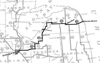 Michigan State Trunk Line No. 31 was designated in 1913, the 22nd trunkline highway route to be designated. It was one of the "original" trunkline routes laid out by the Michigan State Highway Department, which were done in chronological order, starting with T.L.11, T.L.12, etc. to T.L.31. The initial trunkline route began in Saginaw, ran roughly east along the present-day M-81 corridor through Reese to Carrs Corners, then turned northerly along Bradleyville Rd through Gilford, then used today's M-138 through Fairgrove and Akron, then headed north on modern-day M-24 to Unionville, then ran more-or-less along the general route of today's M-25 to Bay Port (although it had a few different routes northeast of Sebewaing in the first several years), then ran pretty much along the exact route of modern-day M-142 through Pigeon, Elkton, Bad Axe and Verona to Ruth Rd, which, for many years was known as M-51 but back in those days was M-27, where M-31 and M-27 then ran together into Harbor Beach where M-31 had its eastern terminus 92 miles later. (M-27 turned north to run along today's M-25 to Port Austin). Click on the above map for a larger version. Michigan State Trunk Line No. 31 was designated in 1913, the 22nd trunkline highway route to be designated. It was one of the "original" trunkline routes laid out by the Michigan State Highway Department, which were done in chronological order, starting with T.L.11, T.L.12, etc. to T.L.31. The initial trunkline route began in Saginaw, ran roughly east along the present-day M-81 corridor through Reese to Carrs Corners, then turned northerly along Bradleyville Rd through Gilford, then used today's M-138 through Fairgrove and Akron, then headed north on modern-day M-24 to Unionville, then ran more-or-less along the general route of today's M-25 to Bay Port (although it had a few different routes northeast of Sebewaing in the first several years), then ran pretty much along the exact route of modern-day M-142 through Pigeon, Elkton, Bad Axe and Verona to Ruth Rd, which, for many years was known as M-51 but back in those days was M-27, where M-31 and M-27 then ran together into Harbor Beach where M-31 had its eastern terminus 92 miles later. (M-27 turned north to run along today's M-25 to Port Austin). Click on the above map for a larger version. |
| |
M-31 existed pretty much along the same corridor—Saginaw-to-Harbor Beach—from 1913 to 1918 when the first route markers were put up, and then to the early part of 1924 when the so-called "M-31 Extension" along the "Huron Shore Route" from Harbor Beach southerly through Forestville, Port Sanilac and Lexington to Port Huron was added to the route (along modern-day M-25). That added about 62 more miles to the length of M-31, for a total of 154 from Saginaw to Port Huron. This would be the greatest extent for M-31 and would only last for about three years. |
| |
In 1926, the U.S. Highway System was laid out and one of the routes Michigan received was US-31. To minimize any confusion with this new "31-numbered" route, although it was on the other side of the state, the M-31 designation was retired and replaced by no less than four other state highway designations in the spring of 1927! From Saginaw easterly through Reese into Tuscola County, M-31 became a westerly extension of M-81, which it still is to this day. The stair-stepping route through Fairgrove and Akron to Unionville became M-84. From Unionville through Sebewaing to Bay Port, M-31 became part of M-29 which was routed up from Port Huron around the entire Thumb (except between Port Austin through Caseville to Bay Port because there was no highway there yet, so it was temporarily routed south to Bad Axe and then west to Bay Port until the shoreline route through Caseville was completed) which, itself, became US-25 and M-25 later, and is now just M-25. From Bay Port across Huron Co through Bad Axe to Harbor Beach (essentially today's M-142 route), M-31 was redesignated as M-83. From Harbor Beach southerly to Port Huron, M-31 was again replaced by the M-29 designation along present-day M-25. These changes took effect on May 15, 1927. |
| History: |
1913–1914? – According to internal Michigan State Highway Dept records, the original establishment records for the route of T.L.31 (Trunk Line 31) in Saginaw Co are "missing" and, therefore, the exact date for the official establishment and assumption of T.L.31/M-31 between Saginaw and Reese is unclear. The original establishment of T.L.31 along Wadsworth Rd from the Pere Marquette Ry crossing (between 14th & 15th Sts) in Saginaw easterly through Buena Vista and Blumfield Twps to the Saginaw/Tuscola Co line at the west limit of the Village of Reese (at Reese Rd) likely occurs at some point in 1913 or 1914 as the majority of the remainder of the route is established through the other counties it travels during these years. |
| |
1913 (July 18) – The first two segments of T.L.31 are officially established as a state trunkline highway route. The two segments in Huron Co both run along today's M-142 in Oliver and Colfax Twps, inclduing Pigeon Rd from Gagetown Rd on the Oliver/Windsor Twp line easterly to the west limit of the Village of Elkton, and Pigeon Rd from the east limit of the VIllage of Elkton easterly to Van Dyke Rd, then southerly for a mile along Van Dyke to the north limit of the City of Bad Axe, for a total of 12.0 miles. |
| |
1913 (July 23) – The 21.15 miles of T.L.31 in southwestern Huron Co in Sebewaing, Fairhaven and Windsor Twps and the Village of Sebewaing is officially established as a state trunkline highway route. From the Tuscola Co line, T.L.31 heads northerly to Sebewaing via Unionville Rd, then continues through Sebewaing along S Beck St, E Main St, N Center St, back to N Beck St and then easterly along Pine St. From Sebewaing, T.L.31 continues easterly along Canboro Rd, then northerly via Gettel Rd, easterly along Kilmanagh Rd to Kilmanangh, then northerly again via Bay Port Rd, easterly along Stein Rd, northerly via Brown Rd and easterly along Weale & Pigeon Rds to Gagetown Rd to the Windsor/Oliver Twp line. |
| |
1914 (Jan 8) – The 4.2 mile concurrent segment of T.L.27 & T.L.31 in eastern Huron Co along Sand Beach Rd (present-day M-142) from T.L.27/Ruth Rd east-northeasterly to Nelson St on the west limit of Village of Harbor Beach is officially established as a trunkline route (as part of T.L.27). |
| |
1914 (Mar 23) – All 22.5 miles of T.L.31 in Tuscola Co, outside of any incorporated villages through which it runs, are officially established as a state trunkline route. From Saginaw Co, the newly-established route of T.L.31 begins at the east limit of the Village of Reese and continues easterly along W Caro Rd (present-day M-81) to Carrs Corner, then northerly along Vassar Rd to Fairgrove Rd, then via Fairgrove Rd to the west limit of the Village of Fairgrove, along Hinson Rd from the north limit of Fairgrove to Akron Rd, easterly via Akron Rd to the west limit to the Village of Akron, easterly again along Akron Rd from the east limit of Akron to Unionville Rd, then northerly along Unionville Rd to teh south limit of the VIllage of Unionville, and finally from the north limit of Unionville to the Huron Co line. |
| |
1914 (Apr 20) –The two-mile concurrent segment of T.L.19 & T.L.31 in central Huron Co along Sand Beach Rd (present-day M-142) from the east limit of the City of Bad Axe easterly to T.L.19/Ubly Rd is officially established as a trunkline route (as part of T.L.19). |
| |
1914 (June 29) – The official routing for T.L.31 in southwest Huron Co is altered when the 3.0-mile route along Canboro Rd from Gettel Rd easterly to Bay Port Rd and Bay Port Rd from Canboro Rd northerly to Kilmanagh Rd at Kilmanagh is officially established as a trunkline highway route and transferred to state control, while 3.0-mile route along Gettel Rd from Canboro Rd notherly to Kilmanagh Rd, then easterly via Kilmanagh Rd to Bay Port Rd at Kilmanagh is cancelled as a trunkline route and turned back to local control. |
| |
1917 (May 3, July 9) – The route of T.L.31 in southwest Huron Co is, once again, altered. On May 3, the existing 10.2-mile segment of T.L.31 along the Canboro–Bay Port–Stein–Brown–Weale from southwest of Kilmanagh to just south of Pigeon is cancelled as a state trunkline route and turned back to county control, while the 10 miles of Volz Rd from Canboro Rd northerly to Stein Rd, continuing northerly via Unionville Rd to Pigeon Rd, then easterly along Pigeon Rd to Brown Rd is officially established as a state trunkline route and transferred to state control. (This leaves a three-mile gap in the officially-established route of T.L.31 along present-day M-142 from Brown Rd west of Pigeon to Weale Rd south of Pigeon.) Then just over two months later on July 9, that gap is filled when the 3.0 miles of Pigeon Rd from Brown Rd easterly into the Village of Pigeon, Michigan Ave easterly to S Main St, then S Main St and Pigeon Rd southerly to Weale Rd are officially established and transferred to state jurisdiction. |
| |
1919 (June 3) – The 1.5 miles of T.L.19 and T.L.31 within the City of Bad Axe—Port Crescent St north of Huron Ave to the north city limit and Huron Ave east of Port Crescent St to the east city limit—are officially established as a state trunkline highway route and transferred to state control. |
| |
1919 (June 11) – The remainder of T.L.31 not yet officially assumed into the state trunkline system east of Bad Axe in Huron Co are officially established in two segments:
- The 10.5-mile segment of Sand Beach Rd (present-day M-142) from T.L.19 south/Ubly Rd easterly to T.L.27 south/Ruth Rd, and
- The 0.65-mile portion of State St (present-day M-142) concurrently with T.L.27 in the Village of Harbor Beach from the west village limit at Nelson St easterly to the terminus of T.L.31 at Huron Ave downtown where T.L.27 turns northerly via Huron Ave toward Port Hope.
|
| |
1919 (July 1) – T.L. 31 is signed in the field as M-31 as all state trunkline highways in Michigan are signed with route markers. |
| |
1919 (Sept 23) – The route of M-31 is realigned in southwest Huron Co northeast of Sebewaing (again!). This time, the 3.0 miles of M-31 along Canboro Rd from Gettel Rd easterly to Volz Rd, then northerly via Volz Rd from Canboro Rd to Stein Rd is cancelled as a state trunkline route and turned back to local control, while the 3.0 miles of Gettel–Kuhl Rds from Canboro Rd northerly to Dutcher Rd (present-day Unionville Rd), then easterly along Dutcher Rd (today's Unionville Rd) to Volz Rd is officially established as a state trunkline and transferred to state control as the new route for M-31. |
| |
1920 (Apr 9) – The last segment of M-31 in Huron Co yet to be officially established as a state trunkline highway route—the 1.0 mile segment through the Village of Elkton (along Whalen and MIll Sts)—is officially assumed into the system and transferred to state control. |
| |
1922 (Jan 25) – The route of M-31 within three villages in Tuscola Co is officially established as state trunkline highway segments, including:
- Fairgrove: W Center St from the west village limit to Main St and N Main St from Center St to the north village limit (1.0 mile),
- Akron: Beach St from the west village limit to the east village limit (1.0 mile), and
- Unionville: Center St from the south village limit to the north village limit (1.15 mile).
|
| |
1923 (May 18) – The last segment of M-31 in Tuscola Co yet to be officially established as a state trunkline highway route—the 0.66-mile segment through the Village of Reese along Saginaw St—is officially assumed into the system and transferred to state control. |
| |
1923 (July 31) – State Highway Dept survey crews complete work on staking out the route of the "Huron Shore Road" extension for M-31 heading southerly from Harbor Beach into Sanilac Co. The so-called "M-31 Extension" to Port Huron has appeared on internal State Highway Dept planning maps since at least 1919. |
| |
1924 (Spring) – While much of the "Huron Shore Road" leading north from Port Huron along the Lake Huron shoreline through Lexington, Port Sanilac, Forestville and into Huron Co was constructed by the local County Road Commissions between 1920 and 1923, it's not until now that it is signed as a marked-and-maintained state trunkline route as the "M-31 Extension" from Harbor Beach southerly to M-19 in downtown Port Huron. Until this point, M-31 ran for 92 miles from Saginaw to Harbor Beach, however with the new "Huron Shore Road" mileage from Harbor Beach to Port Huron, the length of M-31 is increased by approximately 60% to 154 miles total. The extension is only a "marked-and-maintained" trunkline route as it has not yet been officially assumed into the state trunkline highway system. |
| |
1925 (Sept 1) – Two segments of the "Huron Shore Road" portion of M-31 in Sanilac Co are officially established as state trunkline highway routes. First, the 1.4 miles of M-31 along Third St in the Village of Forestville from the north village limit to the south village limit is assumed into the system. Second, the 9.3 miles of M-31/Huron Shore Road in Forester Twp is established, from Russell Rd on the north to Snover Rd on the south. |
| |
1925 (Sept 9) – The entirety of M-31 in Saginaw Co is rerouted. The 11.2 miles of M-31 along Wadsworth Rd from the Pere Marquette Ry (later C&O, present-day CSXT) tracks in Saginaw easterly to the Saginaw/Tuscola Co line at Reese Rd are cancelled as a state trunkline route and turned back to local control, while at the same time, the 10.5 miles of E Washington Rd from the east city limit of Saginaw easterly to the Saginaw/Tuscola Co line at Reese Rd is established as a state trunkline route and transferred to state control. M-31 continues into the City of Saginaw as a "marked-and-maintained" route via E Washington Rd and N Washington Ave to a western terminus at M-10. While officially established as the new route for M-31, the former route of M-31 along Wadsworth Rd remains marked on maps as M-31 for several more years, implying Wadsworth remains a "marked-and-maintained" route until the E Washington Rd route is upgraded to trunkline standards. |
| |
1926 (Mar 8) – The 1.1 miles of M-31/N Washington Ave on the north side of Saginaw from M-10 at the cnr of Washington Ave & 6th Ave easterly to the east city limit is officially established as a state trunkline highway route and transferred to state control. |
| |
1926 (Nov 1) – After several years of negotiation and refinement of a plan, the American Association of State HIghway Officials (AASHO, today's AASHTO) finally approves a nationwide system of coordinated numbered and signed highway routes, including 14 mainline U.S. Highway routes within Michigan. While no part of M-31 is initially included in any of the 14 new U.S. Highway routes—the Harbor Beach-to-Port Huron segment would later be included in an extension of US-25—many state trunkline designations across the state will need to be changed in the next year to accommodate the coming of the new nationwide routes. |
| |
1927 (May 2–15) – As noted above, many state trunkline route designations change as a result of the debut of the U.S. Highway System. In Michigan, US-31 is designated to run up the western side of the Lower Peninsula from south of Niles to the Mackinac Straits area. So as to minimize any possible confusion, the State HIghway Dept chooses to decommission the M-31 designation and not assign it to any other trunkline route in the state. Additionally, the MSHD also chooses to replace M-31 with four different new state highway designations—one of them twice! From Saginaw easterly through Reese to Bradleyville Rd in Tuscola Co, M-31 becomes a westerly extension of M-81 (which it remains to the present-day!), from M-81 stair-stepping northerly and easterly through Fairgrove and Akron to Unionville, M-31 is redesignated as M-84. From Unionville through Sebewaing to just south of Bay Port in Huron Co, M-31 becomes part of M-29. From there easterly through Pigeon and Elkton to Bad Axe, M-31 is redesignated as M-83 and also a temporary routing for M-29, while the M-83 designation is extended easterly to replace M-31 from Bad Axe easterly to Harbor Beach. From Harbor Beach, M-31 southerly through Sanilac Co to Port Huron becomes another segment of the new shoreline route of M-29. While some County Road Commission crews begin to post temporary bearing the new trunkline designations over top of the existing route markers as early as May 2, while the official changeover to the new designations ocurs on May 15. M-31 ceases to be a state route designation and has not existed as once since. |
| Controlled Access: |
At the end of its existence, no portion of M-31 was freeway or expressway. |
| Photographs: |
|
| Weblinks: |
|
| |
|