| Western Terminus: |
M-66 in East Jordan (cnr Lake & Water Sts) |
| Eastern Terminus: |
US-23 in downtown Alpena (cnr 2nd Ave & Chisholm St for eastbound traffic; cnr 3rd Ave & Chisholm St for westbound traffic) |
| Length: |
99.984 miles |
| Maps: |
Route Map of M-32
 M-32: Gaylord-Hillman Existing & Proposed Alignments map M-32: Gaylord-Hillman Existing & Proposed Alignments map |
| Notes: |
M-32 is a relatively major state highway route across the northern reaches of the Lower Peninsula, running from M-66 at East Jordan—its western terminus being just 10 airline miles from US-31 running up the western side of the mitten—easterly through Gaylord and Atlanta, ending in downtown Alpena at US-23, the highway running up the eastern side of the Lower Peninsula. (In fact, from 1963 to 1974, M-32 ran concurrently with M-66 from East Jordan to US-31 at Charlevoix, making it a "true" cross-peninsular route for those eleven years!) In the early 1960s, M-32 from Gaylord to Alpena was classified as a "State Arterial," which was a statewide network of trunklines of an important nature, just below the Intersate system, then under construction. With the debut of the National Highway System (NHS) on November 28, 1995, the portion of M-32, from US-131 easterly to its eastern terminus at Alpena, was added to the system, further denoting its importance, both locally, regionally and statewide. |
| |
 In the early 1960s, when M-32 from Gaylord easterly to Alpena was classified as a "State Arterial" it placed the route a tier above other area trunklines, like M-65 to the east and the segment of M-33 from Atlanta northerly which were classified as "Regional Arterials." This portion of M-32 was built in the 1920s and '30s using then-standard construction methods. However, after several decades, not only had minimum specifications for state highways advanced, the shortcomings of this route had become quite apparent. The State Highway Dept determined this route required major improvements and modernization. The first segment to be upgraded and modernized—meaning improvements in both horizontal and vertical alignments, increasing sight distances, widening the roadway from 20 to 24 feet, widening shoulders and reconstructing portions of the highway—was the Alpena Co segment in 1965, accomplished mostly on or immediately adjacent to the existing highway, save for one short realignment near Lachine. At the time this project was underway, the State Highway Dept released recommendations on improvements and realignments between Gaylord and Atlanta and from Atlanta to the MontmorencyAlpena Co line. However, funding shortages postposed construction into the 1970s, when the westernmost three miles of this segment from Gaylord easterly was realigned and modernized. In the early 1960s, when M-32 from Gaylord easterly to Alpena was classified as a "State Arterial" it placed the route a tier above other area trunklines, like M-65 to the east and the segment of M-33 from Atlanta northerly which were classified as "Regional Arterials." This portion of M-32 was built in the 1920s and '30s using then-standard construction methods. However, after several decades, not only had minimum specifications for state highways advanced, the shortcomings of this route had become quite apparent. The State Highway Dept determined this route required major improvements and modernization. The first segment to be upgraded and modernized—meaning improvements in both horizontal and vertical alignments, increasing sight distances, widening the roadway from 20 to 24 feet, widening shoulders and reconstructing portions of the highway—was the Alpena Co segment in 1965, accomplished mostly on or immediately adjacent to the existing highway, save for one short realignment near Lachine. At the time this project was underway, the State Highway Dept released recommendations on improvements and realignments between Gaylord and Atlanta and from Atlanta to the MontmorencyAlpena Co line. However, funding shortages postposed construction into the 1970s, when the westernmost three miles of this segment from Gaylord easterly was realigned and modernized.
For the Gaylord–Atlanta and Atlanta–Hillman portions, the State Highway Dept recommended realigning major portions of the route, while modernizing the remainder (see map). Right-of-way for the Atlanta–Hillman segment was purchased, although construction was then delayed due to a shortage in highway funding and the passage of new laws. In the midst of the delay, several new state and federal statutes came into effect to mitigate many of the environmental and socio-economic issued caused by transportation projects. This meant the two remaining projects needed to be restudied. MDOT began work on a Draft EIS for the Atlanta–Hillman section in the 1970s, with alternatives presented in 1979. The selected alternative departed the existing route 3½ miles east of Atlanta and ran east-northeasterly, bypassing Hillman to the south before merging back into existing M-32. However, based on feedback, MDOT considered a new alternative consisting largely of updating and upgrading the existing roadway with a few stretches constructed on new location, including the southern bypass of Hillman using a portion of the right-of-way purchased in the 1960s. This change was largely driven by several state and federal agencies stating MDOT would not be granted the necessary permits to perform work on the mostly new alignment route. After additional hearings, revisions, and approvals, construction finally began on the Atlanta–Hillman segment in the 1990s and was complete and open to traffic in 1994, more than three decades after planning first began for the improvements. (The unused right-of-way for the new location route which was not built was later sold off by MDOT.)
Also in the late-1970s, MDOT announced the Turtle Lake Rd (east of Gaylord)–Atlanta segment of the M-32 modernization and upgrade project would be re-studied on its own and would include the so-called "Atlanta Bypass"—a proposal to link the two long, straight segments of M-32 east and west of Atlanta in a direct line instead of having M-32 (as well as M-33 coming in from the east) passing through four turns and down Atlanta's main street. This project would consist upgrading an existing county road (Barrett Rd) from Turtle Lake Rd southeast of Gaylord easterly for five miles, then dip southeasterly and easterly via a new alignment to Heatherton on the Otsego/Montmorency Co line, then easterly along another straigtened and upgraded county road (CR-620/Old State Rd) before striking out again on a new alignment arching northeasterly then southeasterly to merge back into the existing M-32 about two miles west of Big Rock (see map). However since this time, the only 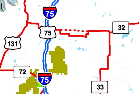 somewhat "major" work done on this section of M-32 has been to replace a set of sharp curves just west of F-01/Meridian Line Rd at Vienna Corners with much gentler ones and a short realignment approaching the county line. While it would seem to indicate MDOT has similarly chosen to modernize and upgrade the existing route between Turtle Lake Rd and Atlanta, the proposed "more-direct" new alignment route remains on the Federal Highway Administration's NHS System map for Michigan (see included map snippet), implying there may still be concrete plans to realign this segment of highway in the future—or else, MDOT has not updated the FHWA on possible plans to scrap the new construction route and, rather, just perform upgrades on the existing alignment. somewhat "major" work done on this section of M-32 has been to replace a set of sharp curves just west of F-01/Meridian Line Rd at Vienna Corners with much gentler ones and a short realignment approaching the county line. While it would seem to indicate MDOT has similarly chosen to modernize and upgrade the existing route between Turtle Lake Rd and Atlanta, the proposed "more-direct" new alignment route remains on the Federal Highway Administration's NHS System map for Michigan (see included map snippet), implying there may still be concrete plans to realign this segment of highway in the future—or else, MDOT has not updated the FHWA on possible plans to scrap the new construction route and, rather, just perform upgrades on the existing alignment. |
| |
From 1963 to 1974, while M-32 ran concurrently with M-66 from East Jordan into Charlevoix, this route was a "cross-peninsular" highway: it extended from Lake Michigan at Charlevoix to Lake Huron at Alpena. |
| |
In October 1982, the Reflective Systems Unit of MDOT began reviewing the state trunkline sytem and "discovered a substantial number of dual and some triple routing on both the free access and limited access system." The result of which was forwarded to "the Trunkline Numbering Committee in an attempt to reduce as much of this unnecessary routing as possible in an attempt to avoid driver confusion and save funds." That December, the MDOT Transportation Planning unit proposed "M-32 Signing ending at M-66." In March 1983, the Supervising Engineer of the Reflective Safety Unit replied "District Traffic and Safety Engineer, Bruce Conradson, has already removed the signs along this section of M-66." M-32 had been shown on the Official Michigan Transportation Map starting in 1974 as having been removed from M-66 between East Jordan and Charlevoix segment, so the actual route markers would have been removed in the 1974–1982 timeframe. |
| |
The Traverse City Record-Eagle reported on September 18, 2005 that local officials from municipalities in southwest Charlevoix and northwest Antrim counties were interested in petitioning MDOT to extend M-32 westerly from East Jordan through the Ellsworth area to US-31 near Atwood, once again restoring the route as a true "cross-peninsular" highway. Some of the officials were considering asking MDOT to assume control of what is now designated C-48, however the route is currently not up to state trunkline standards throughout, so additional upgrades would have been necessary before it could receive the M-32 designation. The article also noted: "Five local governments in Antrim and Charlevoix counties passed resolutions in favor of M-32's extension, with another three expected to take up the issue soon." In the interim, the local authorities teamed up to "brand" the route of C-48 from US-131 at Boyne Falls to US-31 at Atwood "The Breezeway." In 2009, "Breezeway" directional signage and milemarkers were erected along that portion of C-48. |
| |
In "State Trunkline Needs, 1960–1980," a set of maps prepared by the State Highway Dept's Office of Planning, Programming Division in 1960 showing possible additions, upgrades and improvements to the state trunkline system over the ensuing twenty years, MSHD staff recommended several realignments and upgrades to the route of M-32 during that timeframe, including:
- Turning back all of M-32 west of US-131 in northeastern Antrim and southern Charlevoix Cos. This reccommendation was, of course, never implemented as M-32 exists to this day between US-131 and East Jordan.
- Constructing a new alignment M-32 beginning at an interchange with the proposed US-131 freeway at the location of the present-day US-131 & M-32 WEST in northeastern Antrim Co, then proceeding east-southeasterly crossing existing M-32 at Dobleski Rd and bypassing Elmira to the south. The new alignment route of M-32 would continue directly to the corner of C-42/Alba Rd & State Rd west of Gaylord. The existing route M-32 from US-131 to C-42 would be turned back to local control. This proposal was never implented as well.
- Constructing a new alignment M-32 from east of Gaylord to west of Johannesburg, similar to but somewhat different from what was eventually built in the early 1970s. The 1960 proposal diverged from the existing M-32 alignment at the corner of Wilkinson & Chester Rds east of Gaylord and headed directly southeasterly crossing back over the existing route just east of Big Lake and about 1⁄ 3 mile north of Oley Lake Rd before merging back into the existing route at the northeast corner of Lewis Lake west of Johannesburg. The 1970s realignment that was actually completed began west of Krys Rd and merged back with the existing route at Chester Rd, removing two of the 90° turns and leaving two of them that would've been removed with this 1960 proposal.
- Constructing a new alignment M-32 beginning at the existing 90° turn in downtown Johannesburg and heading due easterly along the section line for about four miles before turning slightly northeasterly in Montmorency Co, returning to the existing route of M-32 at the sharp curve near Speiss Lake/Lake Inez about five miles west of Atlanta. This would have eliminated two 90° turns near Johannesburg and several sharp turns (including two more 90° turns) in western Montmorency Co. While this realignment still seems to be on some future plans, it's highly unlikely MDOT will construct this new alignment for M-32.
- Constructing a new alignment northerly bypass of Atlanta for M-32 and, east of Main St, for M-33 as well. It would have run along the existing portions of Metzger Rd and Pettenger Rd, but would have mostly been new alignment with the old route being turned back to local control. This proposal was not implemented.
|
| History: |
1913 (Nov 14) – The first officially-established segment of M-32—then referred to as Trunk Line 32 (T.L. 32)—is a 1.0-mile segment in northeast Antrim Co from the Otsego Co line at Elmira westerly to T.L. 13 (which would become M-131 in 14 years, now US-131) at the present-day intersection of M-32 & Dobleski Rd. (T.L. 13 through the entirety of Antrim Co is also officially established on this day as well.) |
| |
1918 (Mar 28) – A 13.0-mile segment of T.L. 32 is officially established as a state trunkline route in Otsego Co from the Gaylord east city limit southeasterly in a stair-step fashion to downtown Johannesburg at cnr of Maple St & Heatherton Rd. |
| |
1919 (Feb 10) – Another 25.3-mile stretch of T.L. 32 is officially established in Montmorency and Alpena Cos. Beginning on the Briley/Avery Twp line on the east side of Atlanta, T.L. 32 heads easterly 2 miles via its present-day route, then northerly for ½ mile on McMurphy Rd, easterly again 3 miles along Pleasant Valley Rd, then easterly for a further 4 miles via a yet-to-be built roadway to the hamlet of Earls at the cnr of present-day M-32 & Farrier-Grosinsky Rds, easterly for 1 mile to a 90° turn, then northerly 3 miles to the south limits of Hillman, then one more mile easterly to the Montmorency/Alpena Co line, where it continues for 8.4 more miles to a terminus at T.L. 10 (later M-10, then US-23, now M-65) just south of Lachine. |
| |
1919 (Mar 27) – Just 6½ weeks later, an additional 5.1-mile stretch of T.L. 32 is established in Otsego Co, beginning in downtown Johannesburg then southerly and easterly to the Otsego/Montmorency Co line at Vienna Corners (at present-day F-01). |
| |
1919 (Aug 19) – The remainder of T.L. 32 in Montmorency Co is officially established from the Otsego Co line at Vienna Corners (at present-day F-01) easterly for 2.3 miles along the present-day M-32, then due easterly along the section line via an unbuilt roadway for 2½ miles, then due northerly along another section line for 1 mile to the present-day route 0.6 mile northeast of the hamlet of Bigelow. T.L. 32 then heads due easterly for a mile, northerly again for 1½ miles, then easterly again 5¾ miles before turning southerly along Gerber Rd and then easterly again via State St for 0.35 mile through downtown Atlanta, then northeasterly for another 0.35 mile to the Briley/Avery Twp line where the section established in February 1919 begins. |
| |
1919 (Oct 4) – Another 8.2 miles of T.L. 32 is established in Otsego Co in two segments. First, from T.L. 14 (later M-14, then US-27, now BL I-75) at cnr Otsego Ave & Main St, westerly for 4¾ miles along its present-day route, then westerly another 3 miles via present-day C-42/Alba Rd to Mount Jack Rd. The second segment begins two blocks east of the first (the two blocks of Main St from Otsego Ave to Center Ave was established as part of T.L. 14 two weeks prior) and runs easterly for 0.5 mile along Main St to the Gaylor east city limit, where the segment in March 1918 picks up. |
| |
1919 (Oct 4) – Recognizing the route established as T.L. 32 in east-central Montmorency Co less than eight months prior utilizes 5½ miles of unconstructed roadways, the entire 16.0-mile segment is cancelled a state trunkline route and simultaneously replaced by a re-established route between the same two points, but continuing east from the Briley/Avery Twp line for 4½ miles via the present-day route of M-32, then due easterly via another unconstructed gap for 3.1 miles to just east of Miller Creek, then continuing easterly another 2.9 miles along the present-day route, then another ½ mile via a no-longer-extant roadway to Farrier Rd, then northerly via Farrier Rd ½ mile to the formerly established route at the hamlet of Earls, then easterly for 1 mile to a 90° turn, then northerly 3 miles to the south limits of Hillman, then one more mile easterly to the Montmorency/Alpena Co line. |
| |
1920 (Apr 15–30) – T.L. 32 is signed in the field as M-32 as all state trunkline highways in the Lower Peninsula are scheduled to be signed with route markers during the last half of April. However, with a 3½ mile gap in the established route of M-32 between Elmira and the cnr of Alba Rd & Mount Jack Rd in western Otsego Co, M-32 is signed along a "marked-and-maintained" route via Mount Jack Rd between Alba Rd and Elmira and along Underwood St through downtown Elmira, to the established segment beginning at the Otsego/Antrim Co line. |
| |
1924 (Sept 12) – Noting that the established route for M-32 in east-central Montmorency Co still contains a 3.1-mile unconstructed gap, the State Highway Dept cancels that segment from McSwain Rd easterly to just east of Miller Creek and replaces it with a newly-established 3.5-mile alignment southeasterly from McSwain Rd for a mile, then easterly for another mile, and northeasterly for 1½ miles where it merges back into the previously-established alignment just east of Miller Creek. The roadway along this established section is completed and opened to traffic the next year. |
| |
1925 (Oct 8) – The 3½ mile gap in the established route of M-32 in western Otsego Co from Elmira southerly to Alba Rd is remedied through the cancellation of 2.8 miles of the route of M-32 along Alba Rd from the present-day route of M-32 westerly to Mount Jack Rd, then the establishment of a 6.5-mile route heading northerly for 2½ miles, then westerly from Hallock Rd through Elmira to the established route at the Otsego/Antrim Co line. |
| |
1926 (May 24) – Just over 7½ months after the Elmira-to-Alba Rd segment of M-32 was established in western Otsego Co, filling the last un-established gap in the route, the 3.9-mile segment from Hallock Rd westerly through Elmira to the Antrim Co line is cancelled and simultaneously re-established along generally the same alignment, although this one is certified at 4.0 miles in length. |
| |
1926 (May 25) – The next day, a route change in east-central Montmorency Co is made when the mile-long portion of M-32 from 0.4 mile east of Rea-Rust Rds easterly to Farrier Rd, then northerly along Farrier Rd to the hamlet of Earls is cancelled and a new angling 0.7-mile long route is established between those points, cutting off the 90° turn en route. |
| |
1926 (June 19) – Another route change, this time in west-central Montmorency Co, occurs when the 3.1-mile unconstructed stretch from just west of Buttles Rd due easterly for 2.1 miles, then due northerly for another mile is cancelled and immediately replaced by a 3.8-mile route established along an existing roadway between those same two points, via the hamlet of Bigelow. |
| |
1926 (Oct 20) – A 0.6-mile long "spur" off M-32 running along State St through downtown Hillman is officially established and, at the time, referred to as "M-32 EXT" (meaning M-32 Extension), but is likely not signed in the field as such. (This is today's BUS M-32 at Hillman.) |
| |
1927 (May 15) – The debut of the U.S. Highway system in the State of Michigan becomes official as well as many modifications to other routes affected by those changes. M-32's western terminus had been at M-13 a mile west of Elmira, which now becomes M-131 (a de facto northern extension of US-131 which, at this point, terminates at Fife Lake). The eastern terminus of M-32 in Alpena also switches from M-10 to US-23. |
| |
1933 (July 12) – The route of M-32 is extended for 14.1 miles across northeastern Antrim Co and into southern Charlevoix Co. beginning at the route's western terminus at M-131 west of Elmira and continuing westerly for a mile via the present-day route, then turning northerly for 0.6 mile via present-day US-131/M-32, then west-northwesterly along its present-day route (then designated as Co Rd 657) to a new western terminus at M-66 at the cnr of present-day Mount Bliss & Rogers Rd southeast of East Jordan. |
| |
1935 (May–June) – Based on the addition of M-32 route symbols to the segment of US-23 from the eastern terminus of M-32 near Lachine easterly into Alpena, effectively making this segment concurrently designated as US-23/M-32, it is assumed route markers are similarly added to this road in the field around the same time. This is likely done as the State Highway Dept is preparing plans to reroute US-23 closer to the Lake Huron shoreline between Alpena and Rogers City. |
| |
1935 (Oct 22) – M-66 along Mount Bliss Rd south of the M-32 junction southeast of East Jordan is cancelled as a state trunkline route when M-66 is relocated to run into town west of the Jordan River. M-32 is therefore is extended by 2½ miles through East Jordan to a new western terminus at the relocated M-66 west of downtown. |
| |
1939 (mid-Apr) – All of M-131 from the northern terminus of US-131 at Fife Lake northeasterly through Kalkaska, Mancelona, and Boyne Falls to Petoskey is redesignated as a northerly extension of US-131. The mile-long concurrent segment of M-131/M-32 west of Elmira then becomes US-131/M-32. |
| |
1938 (Dec 6) – A route change in east-central Montmorency Co is made when the 0.9-mile long portion of M-32 along present-day Niergarth Rd, forming the 90° turn three miles south of Hillman, is cancelled and a new sweeping curve along a new 0.7-mile long route is established bypassing the sharp 90° turn. |
| |
1939 (mid-Apr) – All of M-131 from the northern terminus of US-131 at Fife Lake northeasterly through Kalkaska, Mancelona, and Boyne Falls to Petoskey is redesignated as a northerly extension of US-131. The mile-long concurrent segment of M-131/M-32 west of Elmira then becomes US-131/M-32. |
| |
1939 (Late) – With the relocation of the US-23 designation between Alpena and Rogers City to the (mostly) completed scenic route between the two cities, the concurrent US-23/M-32 segment from south of Lachine into Alpena becomes just M-32. |
| |
1949 (Nov 4) – A new alignment for US-131 in northeast Antrim Co is officially established from the 90° turn in M-32 (at the current north junction of US-131 & M-32) northerly into Charlevoix Co. With this establishment, US-131 is rerouted from the western jct of the two routes (the present-day southern jct) northerly with M-32 for 0.6 miles, then northerly from there along the new route into Charlevoix Co. US-131 had formerly turned east to run concurrently with M-32 for a mile to Dobleski Rd and this section now reverts to being designated only as M-32. |
| |
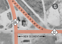 1957 (June 17) – A minor relocation in the route of M-32 at its western terminus in East Jordan occurs when the formerly curving alignment which merges into northbound M-66 (heading toward Charlevoix) is cancelled and M-32 is rerouted to continue due west along Water St to end at M-66/Lake St. The former curvelinear cut-off route is obliterated as a public roadway. (See map at right.) Interestingly, the gas station shown inside the "triangle" is still there today, but is now a real estate office. 1957 (June 17) – A minor relocation in the route of M-32 at its western terminus in East Jordan occurs when the formerly curving alignment which merges into northbound M-66 (heading toward Charlevoix) is cancelled and M-32 is rerouted to continue due west along Water St to end at M-66/Lake St. The former curvelinear cut-off route is obliterated as a public roadway. (See map at right.) Interestingly, the gas station shown inside the "triangle" is still there today, but is now a real estate office. |
| |
1959 – The last five-mile gravel-surfaced stretch of M-32 is hard surfaced during the 1959 construction season, from just west of Pearsall Rd in Charlevoix Co to Adams Rd in Antrim Co. |
| |
1963 (Apr 22) – A compromise between the State Highway Dept and several northwestern Lower Michigan communities (and their chambers of commerce) results in the addition of those communities on I-75 freeway guide signs amd the extension of two state highway routes: M-32 from East Jordan to Charlevoix (concurrently with M-66) and M-68 from Alanson to Petoskey (concurrently with US-31). Previously, Petoskey, Charlevoix, East Jordan and Cross Village did not appear on any exit signage along the new I-75 freeway heading up the middle of the state, thus depriving those resort communities of recognition along the new major thoroughfare, as far as the communities and chambers are concerned. The reasoning cited by the department is "federal regulations on federal highways" require any town displayed on a freeway exit sign to be on the route also shown on that sign, as well as a federal limit on the number of desitnations which can be included on freeway exit signs. To remedy the situation and not be in violation of the regulations, the State Highway Dept decides to extend those routes intersecting I-75 to new termini in the named cities, even though that results in two concurrencies (M-66/M-32 and US-31/M-68) and one triple-concurrency (US-31/M-68/M-131) in the process. Ironically, this move now makes M-32 and M-68 technically "trans-peninsular" highways (similar to other routes to the south, such as M-72, M-55 and M-46), although somewhat shorter in length, due to the taper of the shape of the mitten as you proceed to the north. |
| |
1965 (Feb 11) – As the first step in the overall process of upgrading and modernizing the route of M-32 between Gaylord and Alpena (see the Notes section above), the entire route of M-32 in Alpena Co is modernized and improved during the 1965 construction season. The majority of the improvements are constructed atop the existing highway or within exisitng right-of-way, however one segment of highway is relocated. Starting 0.164 mile east of the western M-32 & M-65 jct at Flanders Corners and continuing northeasterly to the eastern jct of the two routes, the new route, which runs to the north of the former aligment, avoids the edge of Manning Hill and shaves 0.3 mile from the routes of both M-32 and M-65. The former 1.9-mile long alignment along present-day Park Rd is cancelled as a trunkline route and transferred to county control, while the new 1.611-mile M-32/M-65 alignment is established as a trunkline route on February 11, 1965. (The Manning Hill State Roadside Park on the bypassed segment of highway is also transferred to the county.) Overall, M-32 is completely modernized from the Alpena west city limit westerly to the Alpena/Montmorency Co line. |
| |
1964–65 – The second and third stages of the Gaylord–Alpena modernization project (see the Notes section above) marks milestones with the release of Engineering Reports by the State Highway Dept studying "the merits of arecommended alignment for the relocation of M-32," the first of which is relased in March 1964 for the Atlanta–Hillman segment, with a public hearing held on November 12, 1965. The second report, released in March 1965, was for the Gaylord–Atlanta section is published later in 1965, with a public hearing on August 26, 1965. Unlike the Alpena Co stretch, these two stages featured significant segments of new highway construction in order to straighten out the route. The Gaylord–Hillman portion of the route follows a winding and somewhat indirect course and features nearly a dozen 90° turns and just as many less-severe curves. The Atlanta–Hillman second stage calls for modernization of existing M-32 by building a new highway immediately adjacent to and just north of the existing highway from east of Atlanta to ½ mile west of Hall Rd. There, M-32 would angle northeasterly for several miles before turning back again to the east, meeting existing M-32 about a mile south of downtown Hillman. The new alignment then turns east-northeasterly and merges back into existing M-32 at the Montmorency/Alpena Co line. The third stage, Gaylord–Atlanta, involves a new-construction alignment from just east of Gaylord southeasterly to Chester Rd, modernization of the Chester Rd to Thumb Lake Rd segment, then upgrading Beckett Rd (a county road) for five miles before angling southeasterly and easterly on new alignment to Meridian Line Rd (present-day F-01) on the Otsego/Montmorency Co line near Heatherton. From there, CR-620/Old State Rd (a county road) would be straightened and upgraded for 3½ miles where a new alignment route would be built arching northeasterly then southeasterly merging with the existing M-32 at the curve about two miles west of Big Rock. From there easterly toward Atlanta for almost five miles, the existing M-32 would be upgraded and modernized. Then between the first 90° curve west of Atlanta to the last 45° curve east of town, a new aligment ¾-mile long "Atlanta Bypass" would directly connect the exsting long straightaway sections west and east of the community.
(See map showing proposed alignment as well as final routing for M-32 and M-33.)
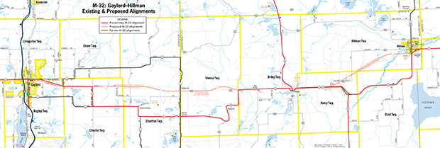 Click on map image for high-resolution version.
 |
| |
1967–68 – The Dept of State Highways completes acquisition on essentially all necessary right-of-way for the "cross-country" segment (from east of Atlanta to Hillman) and the Atlanta bypass segment in Montmorency Co. Right-of-way for a realigned M-33 from its existing east junction with M-32 northwesterly a bit northeast of the existing M-32/M-33 route is also mapped out and purchased. (No right-of-way is yet acquired for the Gaylord–Atlanta stage.) However, limited highway funding stalls any further progress on this project at the same time new environmental legislation is passed both at the state and federal levels. |
| |
1973 (Nov 16) – After the Gaylord–Hillman phases of the M-32 modernization and realignment project stalled, a shorter project east of Gaylord is officially established as a state trunkline route and likely opens to traffic around this time as well. The 3.073-mile segment begins at the Gaylord east city limit and continues southeasterly to east of Kassuba & Chester Rds where it merges back into the existing alignment. The former route of M-32 along Wilkinson and Chester Rds is retained as an unsigned state trunkline route for now. Right-of-way for this project was acquired from late 1970 into 1972. |
| |
1974 – As far as the Official Michigan Transportation Map is concerned, the M-32/M-66 concurrency between East Jordan and both routes' termini at US-31 in Charlevoix comes to an end after 11 years, when the M-32 indication is removed from the M-66 segment, with M-32 returning to its pre-1963 terminus in East Jordan. However, there is some indication the M-32 route markers may have persisted along M-66 for awhile before actually being removed. The reason for the concurrency was a campaign by several northwest Michigan towns to have their communities listed on I-75 freeway exit signs and the only way for that to happen, according to the State Highway Dept at the time, was to extend those routes to those cities, resulting in the concurrent designations. |
| |
1979 (Sept 28) – Due to the implementation of a one-way pair for M-32 in downtown Alpena, the approx 640 feet (0.122 mile) segment of M-32 along Washington Ave between 2nd Ave and US-23/Chisholm St is cancelled as a state trunkline highway route at the same time the approx 485 ft (0.092 mile) of 2nd Ave between Washington Ave and US-23/Chisholm St and the approx 1,010 feet (0.191 mile) 3rd Ave between the same two streets are both officially established as state trunkline routes. Washington Ave between 3rd Ave and 2nd Ave becomes one-way eastbound only for M-32 ebd, which now continues northeasterly along 2nd Ave to a new terminus at US-23/Chisholm St. 3rd Ave becomes one-way westbound only for M-32 wbd traffic between US-23/Chisholm St and Washington Ave where it merges back into the existing route of M-32 to head west out of Alpena. |
| |
1982 (July 29) – The former route of M-32 east of Gaylord along Wilkinson and Chester Rds which was bypassed by the new, more direct, angling alignment in late 1973 is cancelled as a state trunkline route and turned back to county control. |
| |
1982 (Oct)—1983 (Mar) – In October 1982, some MDOT staffers internally propose terminating M-32 at its jct with M-66 at East Jordan and removing the concurrent designation with M-66 between East Jordan and Charlevoix. In March 1983, it is noted the District Traffic and Safety Engineer has "already removed the signs along this section of M-66." (See Notes section above for details.) |
| |
1983 (Apr–May) – After several revisions, a final plan for the Atlanta–Hillman segment of the M-32 modernization project is issued by MDOT in May following a final public hearing on April 21. This plan officially drops the new construction realignment for M-32 from ½ mile west of Hall Rd (east of Atlanta) to Hillman in favor of improvements to the existing route. The final Environmental Impact Statement (EIS), approved by FHWA on May 2, 1984, states, "The recommended [alternative] includes reconstructing the existing M-32 to a 24-foot roadway within a 150-foot minimum right-of-way. The alignment is primarily centered on the existing road, except in areas where corrections are proposed in the horizontal curvature, or to utilize right-of-way previously purchased." |
| |
1994 – After more than two years of construction and involving a complete closure of nearly 12 miles of M-32, the segment of highway from east of Atlanta to Hillman is finally completed after three decades of planning, delays and re-studies. From west to east, the first 1¼ miles of M-32 have been reconstructed immediately to the north of the existing highway to near McSwain Rd, then from there the next 1¼ miles are relocated onto a new alignment using the right-of-way purchased for an M-33 rerouting planned in the 1960s, which helps lessen the sharpness to two curves on the existing route. From east of M-33 toward Hillman, the next 8¾ miles mostly involves improvements and modernization atop the existing highway except for two curves between Rea–Rust Rds and Farrier–Grosinsky Rds which have been made less sharp. Then, just south of Hillman, M-32 now turns northeasterly along a bypass of the village running along the late-1960s right-of-way purchased for a much longer realignment project which never ocurred, replacing one 90° turn with two less acute curves. At the end of the Hillman bypass, the new M-32 merges back into the former route at the Montmorency/Alpena Co line. The two bypassed segments, former M-32/M-33 five miles east of Atlanta and former M-32 on the southern edge of Hillman are turned back to county control on June 30. From a technical perspective within MDOT, the entirety of the 13.126 mile route of M-32 through the project area is cancelled as a state trunkline either through obliteration (11.352 miles) or jurisdictional transfer (1.774 miles) and simultaneously re-established along the new aligment (12.568 miles). Interestingly, because the former route of M-32 at Hillman is transferred to county control, the spur BUS M-32 through downtown Hillman now becomes disconnected from its parent route. |
| |
2004 – Approximately 0.8 mile of M-32 is realigned in eastern Otsego Co in the Vienna Corners area. Beginning approximately ¾ mile west of F-01/Meridian Line Rd, the route of M-32 is adjusted onto a new alignment to remove a set of sharper curves where the highway avoids a small lake/wetland area, then continues easterly to the north of its previous alignment to plug more directly into the route of M-32 in Montmorency Co at the F-01/Meridian Line Rd intersection, eliminating a reverse-curve at that location. The westernmost ½ mile of the former route of M-32 is obliterated as a roadway, while the 0.41 mile segment from F-01/Meridian Line Rd westerly to the beginning of the obliterated segment is retained as a state trunkline route with the name Town Branch Rd and the internal MDOT designation as OLD M-32. |
| |
2009 (May 20) – The former route of M-32 (Town Branch Rd, from F-01/Meridian Line Rd westerly for 0.41 mile) resulting from the 2005 realignment in eastern Otsego Co at Vienna Corners is turned back to County jurisdiction as a County Local road. |
| Controlled Access: |
No portion of M-32 is freeway or expressway. |
| NHS: |
The portion of M-32 from US-131 to its eastern terminus at Alpena, except for a "proposed" segment (as shown on the FHWA's Michigan NHS System map) from the cnr of Beckett & Turtle Lake Rds six miles east of Gaylord to the crossroads known as Big Rock five miles west of Atlanta, is on the National Highway System (NHS). |
| Business Connection: |
BUS M-32 – Hillman. From cnr Hillman Rd & Veterans Memorial Hwy (Old M-32) on the south side of town to a point along State St approx 605 feet north of Progress St. (BUS M-32 no longer connects with mainline M-32.) |
| Memorial Highways: |
The following Memorial Highway designation has been officially assigned to a part of M-32 by the Michigan Legislature:
- Veterans' Memorial Highway – "The part of highway M-32 between Ripley Boulevard and Bagley Street in the city of Alpena..." From MDOT: "Title 38 of the Code of Federal Regulations defines a veteran as “a person who served in the active military, naval, or air service and who was discharged or released under conditions other than dishonorable.” This definition explains that any individual that completed a service for any branch of armed forces classifies as a veteran as long as they were not dishonorably discharged."
|
| Photographs: |
|
| Weblinks: |
|