

| Back to Previous Route: US-8 |
  |
On to Next Route: Former M-9 |
| Western Terminus: | I-96/Jeffries Frwy at Exit 186B in northwest Detroit. |
| Eastern Terminus: | Cnr Davison Ave & Gallagher St, four blocks west of Conant in northern Detroit. |
| Length: | 5.491 miles |
| Map: | |
| Notes: | M-8 is known as either Davison Freeway or Davison Avenue for its entire length. The Davison Frwy portion of the route was constructed along a portion of Davison Ave through Highland Park in 1941–42. This freeway is hailed as the "first urban depressed freeway" ever built. |
 While the original Davison Expressway constructed in the early 1940s only ran a short distance, as the Detroit area expressway system was being proposed and laid out during the 1950s and 1960s, the tiny Davison was destined to become part of a much longer freeway. Plans had been seriously considered to extend the Davison westerly to the proposed Jeffries Frwy at US-16/Grand River Ave, then westerly along Schoolcraft Ave into Livonia, as well as extending the freeway easterly to Mount Elliot Ave and looping around City Airport and down to the proposed "Crosstown Expressway" (now I-94/Edsel Ford Frwy). As some of the originally proposed routes were gradually excluded, the Davison was to run westerly to hook into a realigned Jeffries Frwy and easterly to the proposed Mound Freeway, running north-south along Mound Rd from the Edsel Ford in Detroit to the M-53 freeway in Sterling Heights. The I-96/Jeffries and I-696/Walter P Reuther Freeways were even built with these connections in mind. Construction on the Davison never progressed east of Conant or west of the Lodge, so today the Davison Frwy is a short (less than three miles long) freeway in the heart of Metro Detroit.
By the early 1990s, the Davison Frwy, not yet designated M-8, was in deplorable condition. Reports have it that MDOT hoped to simply "fill-in" the Davison, and re-create a surface Davison Ave, which had been in the 1940s to build the freeway. Many citizens, commuters and groups, notibly the City of Detroit and especially the City of Highland Park, pushed long and hard to have the state reconstruct the Davison as a freeway. With much haggling between local and state officials—including a reported exchange between Detroit Mayor Dennis Archer and Michigan Gov. John Engler—the state finally gave in and agreed to rebuild the Davison as a freeway. The M-8 designation was applied to the reconstructed Davison in late 1995, with new signs along M-10/John C Lodge Frwy showing the M-8 shields erected in July 2000. In 2001 and 2002, jurisdictional transfers between the City of Detroit and MDOT moved control of Davison Ave between I-96/Jeffries Frwy from city control into the hands of the state as a state trunkline. Now, M-8 not only acts as a connector between the M-10/John C Lodge Frwy and I-75/Walter P Chrysler Frwy, but it now continues westerly along a logical routing to also connect with the I-96/Jeffries Frwy at the point where the proposed but never-built westerly extension of the Davison Freeway was to connect to the Jeffries. Whether this is a sign of state-led improvements to come or simply meant to be an aid in motorist navigation in Detroit is yet to be known. |
|
| A website developed by the Wayne County Roads folks on the history of Woodward Ave contains the following quote: "Legend has it that German engineers used Wayne County's Davison Freeway accomplishment as inspiration for the world famous Autobahn." Unfortunately, this cannot possibly be the case, as construction on the the German Autobahnen began in the 1930s and in 1942, when the Davison was completed, the Third Reich was busy battling Allied forces. Not to discount the very high quality construction of the Davison itself, which lasted 54 years before having to be reconstructed, but the Autobahn network in Germany was well underway before construction on the Davison even began. | |
| In "State Trunkline Needs, 1960–1980," a set of maps prepared by the State Highway Dept's Office of Planning, Programming Division in 1960 showing possible additions, upgrades and improvements to the state trunkline system over the ensuing twenty years, MSHD staff recommended numerous upgrades, relocations and new freeway proposals statewide, including several across the Metro Detroit area. One such proposal was to extend the Davison Frwy east and west and incorporate it into the route of M-14. See a complete discussion of this proposal in the Notes section of the M-14 route listing. | |
| History: | 1941 (Mar 17) |
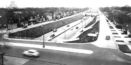
| 1942 (Nov 25) – The $3¼-million, 7,000-foot long Davison Expressway is completed several months ahead of schedule and opened to traffic through Highland Park to provide better access to the manufacturing facilities in the area, especially during this wartime production period. It is hailed as the first urban "depressed" freeway. The freeway runs along the path of the former Davison Ave from Hamilton Ave on the west to just beyond Oakland Ave on the east. | |
 Davison Expressway looking west near Brush St overpass, November 1942. |
|
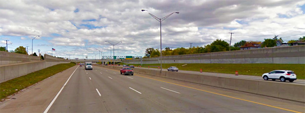 Davison Freeway looking west near former location of Brush St overpass, October 2015. |
|
| 1957 (Nov 7) – The interchange at the western end of the Davison Expwy which now ties into the John C Lodge Expwy (present-day M-10) is completed and opened to traffic along with an 1½ miles of additional John C Lodge Expwy which is also completed and opened to traffic. | |
| 1964 (Nov) |
|
| 1966 (Apr 4) – A new easterly extension of the Davison Expwy is officially established as a state trunkline route from just west of the I-75/Walter P Chrysler Frwy (under construction) easterly to Conant Ave. The actual freeway would not be open to traffic until 1968, however. A state trunkline designation appears not to have been assigned to the new route | |
| 1966 (May 11) – An additional short segment of the Davison from just west of the I-75/Walter P Chrysler Frwy (under construction) westerly to Brush St in Highland Park is officially established as a state trunkline route. The remainder of the Davison Expwy from Brush St westerly to the US-10/John C Lodge Frwy remains as a county-maintained freeway. | |
| 1968 – With the opening of the I-75/Chrysler Frwy, the Davison Expwy is extended easterly from Oakland Ave into Detroit to end just west of Conant Ave. | |
| 1968 (Nov 13) – In response to the passage of the Federal-Aid Highway Act of 1968 which, among other things, authorizes an additional 1,500 miles of Interstate highway nationally, the State Highway Commission announces a request containing 600 miles of additional Interstate mileage within the state. Since the entire nationwide allotment for additional Interstate mileage is 1,500 miles, MSHD officials are aware, however, their request is unlikely to be granted in its entirety. One of the requests is to extend the Davison Expwy in Detroit both westerly from its terminus at BS I-696/John C Lodge Frwy to a new terminus at the proposed I-96/Jeffries Frwy and easterly from its east end, looping around Detroit City Airport to a terminus at I-94/Edsel Ford Frwy on the east side of Detroit, for a total of 9 additional miles of freeway. (No potential Interstate route designation for the Davison Frwy is suggested in the request.) This request is ultimately not granted by the federal government. | |
| 1970 (Nov) – The State Highway Dept begins initial survey work on a complete reconstruction of the Davison Frwy from the I-75/Walter P Chrysler Frwy westerly to the US-10/John C Lodge Frwy as well as a westerly extension to the planned I-96/Jeffries Frwy, a total of 3.6 miles. Construction, at this point, is planned to begin in 1976. | |
| 1993 (June) – After having been built in the 1940s and maintained (although some may question the inclusion of the word "maintained") by the Wayne County Road Commission for next five decades as the only county freeway in Michigan, the decision to transfer the fifty year old freeway from county to state control is made, although the official transfer wouldn't occur for more than two years—closer to the time that MDOT is planning to reconstruct the older segment of the freeway. | |
| 1995 (Oct 1) |
|
| 1996–97 – Between April 1996 and October 10, 1997, the Davison Frwy between M-10/John C Lodge Frwy and I-75/W P Chrysler Frwy was closed for a $45 million reconstruction project. Up until this time, the Davison still had its original 1942 concrete surface and original narrow single-span overpasses. (It was built with three lanes in each direction with no shoulders and a small grassy median only a few feet wide.) The newly opened freeway now has a total of eight lanes (four each firection), as well as ample shoulders on the left and right sides. There is now an interchange at M-1/Woodward Ave, where there used to be none. The eastbound lanes opened at 1:00pm, while the westbound lanes were open to traffic by 4:00pm on Wednesday, October 10th. The portion of the Davison east of I-75 was constructed in the 1960s in conjuction with the I-75 construction. This segment of the freeway is in pretty bad shape, however there seems to be little funding to upgrade this segment in the near future. | |
| 1997 (Oct 10) – The M-8 designation is physically added to the Davison Frwy when it reopens for traffic on October 10, 1997. Prior to this, M-8 was designated on paper only. | |
| 2001 (Mar 15) – The 1.9 mile portion of Davison Ave between I-96/Jeffries Frwy and Rosa Parks Blvd in Detroit is transferred to state control as a state trunkline. Ironically, the 0.14 miles of Davison Ave/Frwy between Rosa Parks Blvd and the M-10/John C Lodge Frwy interchange were not included in the transfer, likely due to this portion being under the jurisdiction of the Wayne Co Dept of Public Services and not the City of Detroit! This means there is now a 0.14 mile gap in the route of M-8. | |
| 2002 (Feb 22) – Nearly a year after the 1.9 miles of Davison Ave were transferred to the state (see above), the remaining 0.14 mile gap between Rosa Parks Blvd and the M-10/John C Lodge Frwy interchange are now transferred from county to state control. Thus, M-8 is officially one, continuous route. | |
| Controlled-Access: | Freeway: From Rosa Parks Blvd in Detroit immediately west of the M-10/John C Lodge Frwy interchange to the eastern terminus of M-8. |
| Expressway: None. | |
| NHS: | The entire length of M-8 is part of the National Highway System (NHS). |
| Memorial Highway: | The following Memorial Highway designation has been officially assigned to part of M-8 by the Michigan Legislature:
|
| Photographs: | |
| Weblinks: |
|
| Back to US-8 | Route Listings Home | On to Former M-9 |