

| Back to Previous Route: M-8 |
 |
On to Next Route: US-10 |
| M-9 is a former state trunkline route existing: 1.) from May 2, 1927 to October–December, 1928 and 2.) from Early 1929 to April–May, 1940, and as a former proposed state trunkline route existing from the mid-1980s to the 1990s**. |
|
| Southern Terminus*: | Ohio state line approximately 5½ miles southeast of Frontier in Hillsdale Co (at a connection with OH SR-15, originally SR-9). |
| Northern Terminus*: | US-27/M-78 in Lansing at cnr Logan St & W Main St |
| Final Length*: | 87.2 miles* |
| Maps: | Route Map of Former M-9 (1939) Route Map of Proposed M-9 (1980s-90s, as M-275 in 1974) |
| Notes: | * The termini and final length for M-9 reflect the beginning and ending of the route and its length as of the time of the physical route's most recent decommissioning in April–May, 1940.** |
| ** The third "iteration" of M-9 was only a proposed route designation and was never physically signed along any route in the field, so, therefore, never had any physical termini or any actual mesurable length. The timeframe in which it was being used in planning documents is also rather "fuzzy" as well. | |
| The history of M-9 as a state trunkline designation is an interesting one, having three iterations—two of them physical and the last one only proposed. The first M-9 only existed for approximately a year-and-a-half as a very short trunkline spur serving the small community of Eagle Harbor in Keweenaw Co in the far northernmost reaches of the Upper Peninsula. After the State of Ohio designated a State Route 9 (SR-9) to run from Cincinnati all the way to the Michigan state line south of Hillsdale, the Michigan State Highway Dept decided to redesignate its M-64 which picked up from the northern terminus of Ohio's SR-9 and continued to Albion and then continued northerly along a newly-designated highway from Albion through Eaton Rapids to Lansing. Ironically, just two years after all the M-64 route markers were swapped out for M-9 signs, Ohio redesignated its SR-9 heading south away from the state line to SR-15 (due to the majority of SR-9 in that state being replaced by the southerly extension of US-127 in 1930). After a decade of M-9 being the northern extension of Ohio's SR-15, the State Highway Dept redesignated M-9 in its entirety to M-99 when all single-digit state highway designations around the state were removed and purportedly banked for future use for a proposed "superhighway" system. The second iteration of M-9 has been designated M-99 ever since. | |
When originally laid out in the 1950s, the Interstate Highway System for Michigan only included a western (north-south) Interstate bypass of Detroit running as far north as what eventually became I-696 in the Novi/Farmington Hills area of south-central Oakland Co. The State Highway Dept and its later successors long felt a northerly extension of this route was necessary to close the gap between I-96/I-696 and I-75 northwest of Pontiac. This proposed route had many identities and personalities over the years, including:
|
|
| Planning studies for a north-south state trunkline corridor in central/west-central Oakland Co continued through the 1980s, although Governor James Blanchard directs MDOT Director James Pitz in 1986 to "develop a plan to ease congestion along the I-696 corridor between I-96 and US-24, and in particular, in the Haggerty Road area." Blanchard notes the congestion in the Haggerty Rd corridor as being "a danger to the quality of life and safety of the residents" and requests "a plan that could be implemented and completed 'as soon as possible.'" Pitz submits his "I-696 Corridor Improvement Program" plan on September 1 which includes several updates and improvements to the I-696 corridor, including "Construct a connection between Haggerty Road and I-96/I-696/I-275 to provide improved access between those freeways and Haggerty Road and to expand capacity in the Haggerty Road corridor up to the vicinity of 15 Mile Rd." This eventually results in the construction of the M-5/Haggerty Connector in the footprint of the original I-275/M-275 corridor, opening to traffic between 1994 and 2002. North-south corridor planning continued through the 1990s and into the 2000s, although the M-9 route designation has not seemed to be attached to this effort since the 1990s. | |
Over its three iterations, the total route length of M-9 was:
|
|
| History: | 1919 (Sept 22) – The segment of trunkline which would eventually become the first iteration of M-9 is officially established as a state trunkline route, but will not be designated as M-9 for nearly eight years. The 5.0-mile long segment of highway in question is designated as one of three legs of M-15 in Keweenaw Co—multi-legged trunkline routes weren't a rare thing in the early days of the state highway system in Michigan—and consists of the entirety of Eagle Harbor Rd (from present-day US-41 west of Central northeasterly to the present-day jct with M-26 at Eagle Harbor). At this point, M-15 in Keweenaw Co consists of present-day US-41 from Allouez to Copper Harbor, this Eagle Harbor Spur, and the Eagle River Spur from Phoenix into Eagle River. |
| 1927 (May 2) – The new US Highway designations across the state of Michigan officially become effective today, with US-41 superseding the entire route of M-15 in Michigan. As multi-legged highway routes are no longer "a thing" with the State Highway Dept, especially with the new US Highway routes, the Eagle River and Eagle Harbor spurs are each given state route designations, M-6 and M-9, respectively. Road crews erect temporary cardboard route markers over the existing state trunkline route markers for all new US Highways and changed state highways as a result of the new US Highways. This marks the debut of the first iteration of M-9. (The State Highway Dept plans to have permanent markers in place by midsummer.) | |
1928 (Apr 2) – City of Lansing voters approve a bond issue to replace the old, failing Logan St bridge spanning the Grand River with a new structure which will now also overpass the Grand Trunk Railway tracks running along the river and also lead to the nearby Oldsmobile plant, which consists of 10 individual grade crossings and the site of numerous fatal accidents. The new viaduct is also the reason the State Highway Dept begins considering an extension of the route of M-64 from Albion northerly for approximately 38½ miles via Springport and Eaton Rapids, entering Lansing from the south via Logan St and using the proposed Viaduct to a terminus at US-27/W Main St. However, while the new trunkline route between Albion and Lansing will be officially established later in the year signed within 10 months, it will not be an extension of M-64. (Sketch of proposed Logan Street Viaduct below—click for larger version.)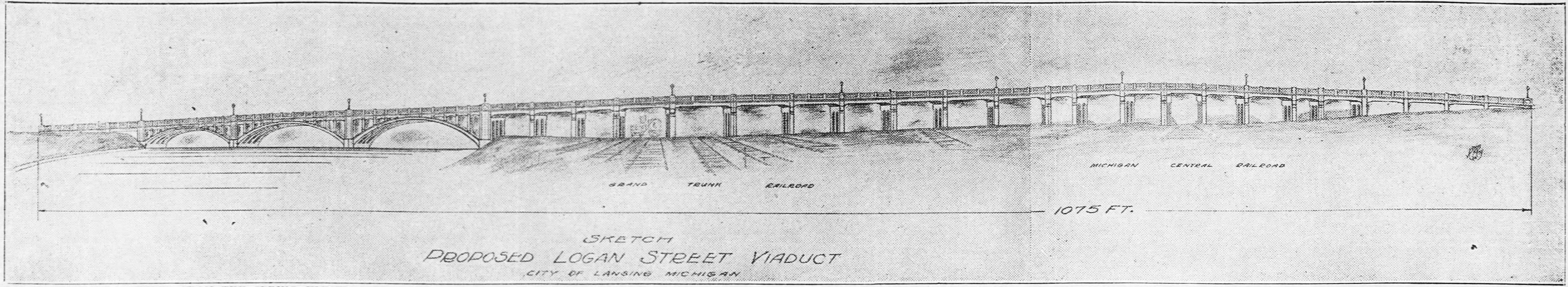 |
|
1928 (June 28) – The northerly extension of the new Indiana-to-Albion trunkline, heretofore designated as M-64, is officially assumed into the state highway system. Specifically, the following segments are established as part of the new trunkline route:
|
|
| 1928 – During 1928, the decision is made to redesignate all of M-64 from the Ohio state line northerly through Hillsdale, Jonesville, Litchfield, and Homer to Albion as M-9 and then extend the M-9 designation northerly along the newly-designated trunkline route from Albion through Eaton Rapids to Lansing. The redesignation is done because the designation across the border in Ohio of the state route continuing southerly all the way to Cincinnati is Ohio SR-9. By making this change, a motorist could drive from Lansing, Michigan to Cincinnati, Ohio on a route bearing the same number throughout: M-9 and SR-9. This means, of course, the existing M-9—the short, 5-mile long spur from US-41 to Eagle Harbor in Keweenaw Co—will need a new state trunkline route designation. The State Highway Dept decides to simply swap the two designations and reassigns the M-64 designation to replace M-9 in Keweenaw Co. | |
| 1928 (Oct–Dec) – The State Highway Dept replaces the M-9 markers on the Eagle Harbor Spur in Keweenaw Co with M-64 markers in the fall, with work likely completed by mid-December. However, M-9 route markers are not instantly installed on the new Lansing-to-Albion trunkline route that was established in June, nor are the M-64 markers removed or replaced from Albion southerly to the Ohio line, according to contemporary newspaper evidence, thus, for the time being, there are actually two M-64 routings in the state! | |
1929 (Winter–Spring) – The signing of the Albion–Lansing trunkline route as M-9 is completed with news reports noting the route being signed as such as early as February and as late as April. The route for the new M-9 is:
|
|
| 1929 (Aug 29) – The ½ mile of E Main St in Springport from Green St (which is the officially-established route of M-9, although not signed as such at present) westerly into downtown at the cnr of Main St & Maple St-Mechanic St is officially established as a state trunkline highway route. While this half-mile of street has been recently signed as the "marked-and-maintained" route of M-9 through Springport, pending the completion of the yet-to-be-built route of M-9 to the east of the downtown area, the actual reason it is official brought into the state highway system is to provide highway access to downtown Springport once the M-9 "bypass" is completed in the future. Officially this ½ mile of E Main St is designated as M-160 by the State Highway Dept but, as already noted, it is currently (temporarily) signed as part of M-9 for the time being. | |
| 1929 (Fall) – The remainder of the (Lower Peninsula version of) M-64 is likely converted to M-9 as all remaining route markers are swapped out for M-9 signs from Albion southerly to the Ohio state line. The only M-64 is now the "new" one which swapped placed with the "original" M-9 in Keweenaw Co. | |
| 1930 (Nov 22) – The 0.683 mile segment of US-12/E Michigan Ave in Albion from downtown at Superior St easterly to Mingo St is officially established as a state trunkline highway segment. It had been part of M-17 since 1913 and posted as such beginning in 1919, then as part of US-12 since 1927, but is now officially under State Highway Dept control, also concurrently designated with M-9. | |
| 1930 (Dec 2) – The State Highway Dept takes the first step in a major realignment project for M-9 in central Hillsdale Co. Up to now, has M-9 followed the former route of M-64 from the Ohio state line northerly along Pioneer Rd to Burt Rd, then stair-steps into Frontier via Burt Rd (jogging to the north at Crampton Rd), Clark Rd and Montgomery Rd. West of Frontier, M-9 turns northerly via S Hillsdale Rd for 9½ miles into downtown Hillsdale where it meets M-34. A new alignment for M-9 is established along Pioneer Rd from Burt Rd northerly 2.0 miles to Tamarack Rd, then due northerly through the countryside via a yet-to-be-constructed highway for 6.0 more miles to a ⊤-intersection with the newly-established alignment for M-34 (assumed into the system on this same day) running between Pittsford and Hillsdale). M-9 would then turn left and follow the new M-34 alignment via a yet-to-be constructed highway into Hillsdale from the southeast. The 13.9 miles of existing M-9 route along Burt, Clark, Montgomery and S Hillsdale Rds is officially turned back to local control, however until the new alignment for M-9 is constructed it will continue to follow its existing route as a "marked-and-maintained" state highway. As an aside, on the same day, the 2.2 miles of Montgomery Rd from the newly-established route of M-9 at Pioneer Rd westerly to the existing route of M-9 at Clark Rd at Frontier is also established as a new state trunkline highway route, to be designated as M-158 and function as a state highway spur serving the community of Frontier from the new through route of M-9, once that highway is constructed in the future. |
|
1931 (June 14) – Act 131 of 1931—the Dykstra Act—is passed allowing the State Highway Dept to take over control of state highways running into and through incorporated cities, thereby officially incorporating them as state trunkline highways. For M-9, three segments of of the route are affected, totalling 1.6 miles:
|
|
| 1932 (Oct 29) – A short realignment for M-9 removes the route from present-day Bailey Rd between Dimondale Hwy and Vermontville Hwy, which is turned back to local control, while the current route of M-99 is officially established as a state trunkline route between those same two points. The transferred and assumed mileage for both segments is 1.6 miles. | |
| 1934 (Spring/Summer) – After some delay, construction is completed on upgrading the existing county roads which will become the new routes for M-9 (Pioneer Rd between Burt and Montgomery Rds) and M-158 (Montgomery Rd between Pioneer and Clark Rds). The marked-and-maintained route of M-9 is removed from the Burt–Crampton–Burt–Clark Rds route and moved to its official route along Pioneer Rd between Burt Rd and M-158/Montgomery Rd, where it turns westerly along the newly completed M-158 back to its marked-and-maintained route along Montgomery and S Hillsdale Rds between Frontier and Hillsdale. While it's not clear if M-158 is signed along the 2.2 miles of Montgomery Rd from M-9/Pioneer Rd westerly to Clark Rd (concurrently with M-9), the route is shown on official State Highway Dept maps issued to the public for the rest of the year and through most of 1935, so it may well have been. | |
| 1935 (Jan 7) – M-9 is rerouted between Albion and Homer. The 8.1-mile long former route between the two communities via Irwin Ave (within Albion), B Dr South, 25½ Mile Rd and N Webster St (in Homer) is turned back to local control, while S Superior St (in Albion from Irwin Ave southerly) and 28 Mile Rd to M-60 is transferred to state control (5.3 miles) as the new route for M-9. The route of M-9 now runs concurrently with M-60 between 28 Mile Rd and downtown Homer. | |
| 1935 (Oct 22) Similarly, the 5.3-mile long proposed Springport "bypass" alignment for M-9 in Jackson Co—starting approximately 1¾ miles south of downtown Springport, then northeasterly on an unbuilt roadway to Ferris Rd, then northerly through the eastern portion of the Village of Springport along Green St, then northerly out of the village again on an unbuilt roadway before bending back northeasterly for approximately three miles, merging back into existing M-9 at the Jackson/Eaton Co line—is also cancelled without having been constructed. The existing signed route of M-9, including a 1.7 mile segment from downtown Springport southerly and a 4.7-mile section easterly from Green St in Springport via Springport Rd, then northerly and northeasterly in a stair-step fashion to M-50 near the Eaton Co line, is officially established as a state trunkline route after having been a "marked-and-maintained" route since 1928. The ½ mile section of E Main St in Springport which had been earmarked with the future M-160 designation once the M-9 bypass had been constructed is incorporated into the established route of M-9 and the (future) M-160 designation will go unused. |
|
| 1939 (July 13) Over the county line to the south in Jackson Co, two new segments of M-9 totalling 2.2 miles are established as a state trunkline route, while two segments of the former route totalling 3.3-miles are cancelled, but remain signed as "marked-and-maintained" segments of M-9 until the new route is completed. |
|
| 1940s (early/mid) – Even though the proposed M-9 realignment in south-central Hillsdale Co due northerly along the Pioneer Rd axis from 1930 is officially abandoned in 1935, by the early- to mid-1940s, a very similar realignment route is back on internal official State Highway Dept maps. This time, the proposed route heads north from the cnr of Pioneer & Montgomery Rds for 1 mile, then curves northwesterly to follow the Lake Pleasant Rd alignment northerly to approximately Roseville Rd before bending westerly again to byass Pleasant Lake itself before ⊤-ing into M-34 between Lake Pleasant and Doty Rds west of Osseo. In addition, the MSHD also proposes a realignment for M-9 between Hillsdale and Jonesville continuing due northerly from downtown Hillsdale via Hillsdale St–N Hillsdale Rd to Moore Rd, then angling northwesterly cross country to a point on Homer Rd just north of Ball Rd, then northwesterly via Ball Rd–Maumee St into downtown Jonesville to the jct of US-112 & M-9. | |
| 1940 (Apr/May) – In the spring of 1940, M-9 in its entirety is re-designated as M-99 when all single-digit state highway designations are removed and purportedly banked for future use along a proposed "superhighway" system. This marks the end of the second iteration of the M-9 route designation on the state trunkline system. (See the M-99 Route Listing for a continuation of the history of this route.) | |
| 1980s (Early) – As noted in the "Notes" section above, MDOT continues north-south corridor planning studies in the central/west-central Oakland Co area to alleviate severe traffic problems in the area in lieu of the construction of an I-275 freeway or M-275 parkway linking I-96/I-696 at Novi/Farmington and I-75 near Davisburg. The M-9 route designation is attached to this corridor in planning documents at this point, becoming the the third "iteration," of sorts, of the M-9 route designation, albeit not a phyiscal one. | |
| 1990s – After completion of the M-5/Haggerty Connector in south-central Oakland Co, even though studies are still ongoing for a possible north-south state trunkline route in central/west-central Oakland Co between I-96 and M-59 and possibly I-75, the M-9 designation seems to fall by the wayside and is not mentioned any longer. | |
| Controlled Access: | No portion of former M-9 upon decommissioning existed as freeway or expressway, existing largely before modern-day control of access principles are practiced. |
| Photographs: | |
| Weblinks: |
|
| Back to M-8 | Route Listings Home | On to US-10 |