

| Back to Previous Route: Former M-98 |
 |
On to Next Route: M-100 |
| Southern Terminus: | Ohio state line (connection w/OH SR-15) southeast of Frontier, 18 miles south of Hillsdale |
| Northern Terminus: | |
| Length: | 86.052 miles |
| Maps: | Route Map of M-99 |
| Notes: | Until 1939, what is now M-99 was designated as M-9. At that time, every single-digit state trunkline route was given a two- or three-digit route designation, reportedly to reserve all single-digit designations for a planned network of "superhighways" across the state. While this single-digit-designated "superhighway" network never quite came to be and many of the single-digit route designations were later re-used beginning in the 1970s, the M-9 designation has never been re-used. |
| During the early 1990s, all of Logan St in the city of Lansing was co-named M L King Jr Blvd. Later, all Logan St signs were removed and the street became known only as M L King Jr Blvd within the city, including all of M-99 north of I-96. While MDOT was able to use "M-99 - Logan St/M L King Blvd" on the large overhead signs on I-496 during a mid-1990s re-signing project, all exit signs on I-96 at Exit 101 read "M-99 - Logan St/Eaton Rapids." MDOT, however, did erect smaller auxillary signs before the interchange indicating the M L King Jr Blvd name. In 1999, MDOT covered up "Logan St" on the I-496 exit signs, while brand-new "M-99 - M L King Blvd/Eaton Rapids" signs were erected on I-96. | |
| In Albion, M-99 enters the city from the south via Superior St into downtown, then turns easterly with BL I-94 along E Michigan Ave, exiting the city and meeting I-94 at present-day Exit 124, before proceeding northerly toward Springport. As I-94 was being constructed in the late 1950s, the State Highway Dept's original plans were to reroute M-99 northerly from downtown Albion along Superior St, then westerly on Austin Ave, and then northerly again via Eaton St to the new I-94 freeway at present-day Exit 122. From there, M-99 would have been routed concurrently with I-94 for 2½ miles to present-day Exit 124 where it would turn northerly along its existing route toward Springport. The portion of E Michigan Ave from downtown Albion easterly to I-94 at present-day Exit 124 was to have been turned back to local control, with no Interstate Business Loop (BL I-94) for Albion at all. City leaders protested vehemently and the MSHD acquiesced and created the trunkline arrangement still existant at Albion to this day. | |
In "State Trunkline Needs, 1960–1980," a set of maps prepared by the State Highway Dept's Office of Planning, Programming Division in 1960 showing possible additions, upgrades and improvements to the state trunkline system over the ensuing twenty years, MSHD staff recommended the following changes to the route of M-99 during that timeframe:
|
|
| History: | 1914 – The first iteration of M-99 and the trunkline routes that would eventually comprise that route have a somewhat schizophrenic history. The first state trunkline routes established in 1914 between Montague in Muskegon Co and Shelby in Oceana Co are part of Trunk Line 11 (T.L. 11)—the West Michigan Pike. Various trunkline routes are established and cancelled in the area during the year before finally settling on a final route. On February 14, a four-mile state trunkline route is established in Oceana Co beginning in downtown New Era and continuing northwesterly via present-day Oceana Dr, westerly along Hayes Rd, northerling on Water Rd to Grant Rd, then northerly via Oceana Dr into Shelby, as part of T.L. 11 also known as the West Michigan Pike. As this is several years before trunklines are signed in the field, no route markers are erected along the route. Then on April 10, a six-mile trunkline route is established in northwest Muskegon Co from the west limits of Montague westerly via Dowling Rd, northerly along Lamos Rd, westerly along Post Rd, northerly along present-day Old Hwy 99 to Schneider Rd, then northerly for an additional 0.15 mile along an unconstructed roadway to the Oceana Co line, also as part of T.L. 11 (West Michigan Pike). Not quite 2½ months later on June 20, a 10.4-mile long trunkline route for T.L. 11 is established in Muskegon and Oceana Cos beginning at the cnr of Whitbeck Rd & Eilers Rd at the northwest corner of the village of Montague and continuing northerly 2.9 miles via Whitbeck Rd to the Oceana Co line, then northerly for 7.5 miles along 72nd Ave, easterly via Wilke Rd, then northerly on Water Rd to Hayes Rd northwest of New Era, in the middle of the trunkline segment established previously in February. One month later on July 18 & 20, ALL trunkline routes established up to this point between Montague and Shelby are cancelled in their entirety, including the four-mile Oceana-Hayes-Water-Oceana segment from February between New Era and Shelby, the Dowling-Lamos-Post-Old Hwy 99 route westerly and northerly from Montague from April, and the Whitbeck-72nd-Wilke-Water-Hayes alignment from Montague to south of Shelby from June. The Muskegon portions are cancelled on July 18, while the Oceana segments are cancelled two days later on July 20. Simultaneously, one new 17.8-mile long route for T.L. 11 between Montague and Shelby is established. In Muskegon Co, it duplicates the April route via Dowling, Lomos, Post, and Old Hwy 99 to Meinert Park Rd where it now turns easterly for ¼ mile to Indian Bay Rd, then follows Indian Bay to the Oceana Co line, for a total of 6.2 miles in Muskegon Co. In Oceana, the 11.6 mile segment continues northerly via 56th Ave to Arthur Rd, easterly along Arthur to 64th Ave, northerly on 64th to Hayes to Water Rd, northerly via Water to Oceana Dr, then follows Oceana Dr into Shelby. As with the cancellations, the newly established segments are made official on July 18 in Muskegon and July 20 in Oceana. |
| 1919 (Summer) – Work is completed on Federal Aid Project No.1 (FAP 1) for Michigan—the first highway project in the state under the Federal Aid Road Act of 1916—running directly north from Montague via present-day Whitehall Rd into Oceana Co, continuing northerly via present-day Oceana Dr through Rothbury and New Era to Hayes Rd, then westerly along Hayes Rd to Water Rd (jct T.L. 11/West Michigan Pike), then northerly through Shelby to Hart via the existing route already established as T.L. 11. This new highway, however, is not established as a state trunkline highway route for reasons not currently clear. | |
| 1920 (June 30) – On the official trunkline map issued as part of the "Eighth Biennial Report of the State Highway Commissioner" issued June 30, 1920, the route of Federal Aid Project No.1 between Montague and Shelby is shown as being part of existing M-11—even though it has not yet been established as a state trunkline route!—while the older alignment to the west from 1914 is labeled as being M-99. The majority of both the direct F.A.P. 1 route and the westerly M-99 route are depicted as being "unimproved" between Montague and New Era, however. | |
| 1920 – The first real highway map issued by the State Highway Dept as a guide to the trunkline system for motorists, also issued in 1920, shows M-11 using the original 1914 (westerly) route between Montague and Shelby, with no M-99 shown. | |
| 1921 – Maps issued in 1921 tend to disagree with the route of M-11 between Montague and Shelby. An official map put out by the State Highway Dept shows the F.A.P. 1 route via Rothbury and New Era as being designated M-11, while the 1914 (westerly) route is shown as a state trunkline route, but with no identifying route designation on the map. The 1921 Rand McNally Auto Trails map, however, shows M-11, the West Michigan Pike and the Dixie Highway all using the westerly route, while the F.A.P. 11 route via Rothbury and New Era is shown as a local road. | |
| 1922 – The "West Michigan Pike Tour Guide" from 1922 indicates the route of the West Michigan Pike is realigned between Montague and Shelby to follow the route of F.A.P. 1 through Rothbury and New Era. It is likely the route of M-99—the original westerly alignment of the West Michigan Pike and M-11—between Montague and Shelby is signed as M-99 by this point. | |
| 1926 (July 13) – The State Administative Board decides to abandon M-99 as a state trunkline in Muskegon and Oceana Cos as it parallels M-11 and was, as noted in media reports, "built to serve a farming community." It would take nearly a year-and-a-half to officially effect the transfer, however, and the existing route of M-11 from Montague northerly through Rothbury and New Era has still not yet been assumed into the state highway system! | |
| 1927 (Dec 31) – The Muskegon Co portion of M-99 is offically cancelled and turned back to county control and the apparently-signed route of US-31 (recently commissioned along M-11) from Montague due northerly to the Muskegon/Oceana Co line is established as a state trunkline highway. Since the same changes will not be made in Oceana Co for nearly another year, one could assume: 1) that the M-99 signs are removed from Muskegon but not Oceana, 2) that all markers are left in place until the Oceana transfer can take place, or 3) that all M-99 markers are removed in anticipation of the transfer in Oceana. | |
| 1928 (Dec 18) – The Oceana Co portion of M-99 is turned back to local control and, similar to the 1927 changes noted above, US-31 (nee M-11) is officially established as a state trunkline route from the Muskgon Co line northerly through Rothbury to New Era. If they had not already been removed, all M-99 route markers are likely taken down at this time and the first iteration of M-99 officially comes to a close. | |
| 1929 (Oct 31) – The State Administrative Board approves adding the roadway from Whitedale (present-day Gulliver) in southeastern Schoolcraft Co via present-day Co Rd 432 (McDonald Lake Rd and Port Inland Rd) as a state trunkline highway. The initial reason for adding the route is to provide high-quality roadway access to the massive Port Inland and Inland Quarry developments currently under construction. The Schoolcraft Co Road Commission had initially approved the issuance of $50,000 in bonds to build the road as a county project, but it was soon established that amount of money would be inadequate, so local officials made an effort to interest the State Highway Dept in the project. The second purpose for the route is as a first step in a shoreline scenic highway routing for US-2 between Whitedale (Gulliver) and Naubinway, to compliment similar highway realignments elsewhere along Michigan's Great Lakes shorelines. | |
| 1929 (Dec 2) – The 7.8-mile long Whitedale–to–Port Inland roadway is officially established as a state trunkline route. The new highway is labeled as M-137 on a 1930 State Highway Dept map, although it is unlikely any M-137 route markers are ever erected, as the highway's designation will change before it is complete and fully open to traffic in 1931. | |
| 1930 – In spring, the Whitedale–Port Inland route is referred to as M-137 and shown in news reports as being "Practically impassable." References to route as M-99 begin in August 1930 when the final construction of the highway is put out to bid by the State Highway Dept. Construction gets underway during the summer and the road is reported as "Under construction but passable" by November. Meanwhile, the M-137 designation which was temporarily applied to this route is transferred to a new route in Grand Traverse Co. |
|
| 1931 – The new state trunkline linking US-2 at Whitedale (present-day Gulliver) with Port Inland is completed and fully opened to traffic, signed as M-99. | |
| 1933 – Official State Highway Dept maps this year show M-99 as being scaled back by three miles, theoretically ending at Co Rd 431—the road leading to Seul Choix Point Lighthouse—although the full 7.8-mile route to Port Inland remains established as a trunkline. | |
| 1934 – In mid-1934, the official State Highway Dept maps show M-99 re-extended to the east, terminating again at Port Inland, near the Schoolcraft/Mackinac Co line. | |
| 1939 (July 13) – The second iteration of M-99 comes to an end when the Schoolcraft Co route of M-99 between Gulliver (formerly Whitedale) and Port Inland is turned back to county control and becomes Co Rd 432. | |
| 1940 (April/May) – The third iteration of M-99 debuts as a part of a drive by the State Highway Dept to remove all single-digit route designations, possibly reserving them for a future "Superhighway" program. The M-99 designation, previously utilized 1930–1939 in Schoolcraft Co, is then assigned to the entirety of the routing of M-9 from the Ohio state line to Lansing. While the M-9 route designation was used for a studied north-south trunkline route in west-central Oakland Co connecting I-96 and M-59 in the 1980s and 90s, it has never been physically posted on an actual route in the field since 1940. | |
| 1940 (Aug 28) |
|
| 1940 (Nov 12) – Both M-99 and M-60 are rerouted in Homer. The former route of M-60 (and M-99 east of Hillsdale St) along Main and Byron Sts is turned back to local control while Leigh St one block north of Main is established as the new trunkline routing. Interestingly, though, the one block of Hillsdale St from Main St (former M-60) to Leigh St (new M-60) is not transferred to state control, meaning that while M-99 route markers are likely erected along that one block, it technically remains a city street. | |
| 1946 – The final 8 gravel-surfaced miles of M-99 are paved, between Frontier and the Ohio state line. | |
| 1952–54 – In mid-1952, the 8-mile stretch of M-99 between Litchfield and Homer reverts back to gravel-surfaced from being paved for many years. It isn't until 1954 that the section is again hard-surfaced. | |
| 1953 (Nov 6) – The one block of Hillsdale St in downtown Homer from Main St to M-60/Leigh St is transferred to the state, rectifying what was likely an oversight in the jurisdictional transfers in Homer in late-1940. | |
| 1957 – A curious 1.6-mile long "bypass," of sorts, is constructed along M-60 at the eastern M-99 junction east of Homer and south of Albion, although the new roadway is only used by westbound M-60 (and, west of 28 Mile Rd, by southbound M-99) traffic only, with eastbound M-60 (and, west of 28 Mile Rd, northbound M-99) traffic remaining on the original 1923 alignment of M-60. Reasons given by MSHD officials for the interesting configuration include limited sight distance for wbd M-60 traffic approaching M-99/28 Mile Rd from the east and a high volume of serious crashes at the intersection. | |
| 1960 (Jan 6) – With the completion of the I-94/US-12 freeway around Albion, the formerly concurrent US-12/M-99 stretch in the area becomes M-99/BUS US-12. In addition, a very slight 2/10th mile realignment to the route of M-99/BUS US-12 from the I-94/US-12 freeway southerly to Michigan Ave is officially certified. | |
| c.1960–61 – The BUS US-12 routing at Albion is redesignated as BL I-94, meaning the concurrent M-99/BUS US-12 becomes M-99/BL I-94. | |
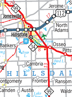
| 1966 (Oct 4) – The route of M-99 through downtown Hillsdale is officially modified to travel around the east and north sides of the "downtown triangle." M-99 formerly entered downtown Hillsdale from the south via Howell St, meeting M-34 at its western terminus at the six-way intersection of Howell St, North St & Broad St, with M-34 approaching from the southeast along Broad St. M-99 then veered northwesterly along Broad St for one block (along the west side of the "downtown triangle," then turned westerly via Carlton Rd toward Jonesville. Now, M-99 approaches downtown Hillsdale from the southeast along Broad St (the former route of M-34—see below), then turns notherly at North St to follow Hillsdale St for one block along the east side of the "downtown triangle," before turning westerly via Carleton Rd toward Jonesville. An uncrossable barrier now separates the trunkline traffic (Broad St southeast of North St and Hillsdale St from North St northerly) from accessing Howell St (south of North St) and Broad St (northwest of North St). | |
| 1966 (Oct 4–14) – A $1.2 million realignment for M-99 is completed and opened to traffic in central Hillsdale Co on October 14. Formerly running westerly from Pioneer Rd via Montgomery Rd through Frontier, then northerly via Hillsdale Rd into Hillsdale, M-99 now runs due northerly 7.15 miles via Pioneer Rd (partially constructed on new alignment) to M-34 near Osseo, then continues northwesterly replacing the M-34 designation into Hillsdale. The more-direct new routing shaves about one mile from the route of M-99. The 13.595-mile long former route is turned back to county control (municipal control in Hillsdale) and the new alignment is officially established as a state trunkline route on October 4, the day originally earmarked for the opening of the new route. Heavy rains delayed final completion for two weeks. | |
 1975 (Mar 6) 1975 (Mar 6) |
|
| 1975 (Apr 1) – The conversion of Logan St (Martin Luther King Jr Blvd) in Lansing commences with the establishment of approximately 0.45 mile of new trunkline beginning at Alsdorf St and running northwesterly to the Grand River then northerly to the intersection of Birch St & Olds Ave. This route will become the new southbound side of M-99 once the project is complete, including a new three-lane bridge spanning the Grand River just downstream of the existing Logan St bridge. Construction begins on the new bridge at this point with work on the remainder of the boulevard south of Alsdorf St and the new parallel alignment for M-99 southbound along Birch St to commence in 1976. | |
| 1977 (Dec 1, 11 am) – On the day the 0.945-mile long segment of southbound M-99 from Kalamazoo St on the west side of Lansing southwesterly to Birch St, then southerly along Birch St to Olds Ave (at the northern end of the new sbd M-99 segment established in 1975) is officially assumed into the state trunkline highway system, the entire southbound side of M-99 between Kalamazoo St and Victor Ave is completed and opened to traffic at 11:00 am. The new sbd M-99 departs existing Logan St at Kalamazoo St and runs southwesterly over a new alignment to Hillsdale St. From there, sbd M-99 is routed over Birch St for four blocks to Olds Ave. South of Olds Ave, the new sbd M-99 turns southeasterly crossing the Grand River on a newly-constructed bridge, then turning southerly to parallel existing Logan St between Pulaski and Alsdorf Sts, becoming a new set of southbound lanes in an upgraded boulevard for Logan St to Victor Ave. Existing Logan St from Victor Ave northerly to Kalamazoo Ave becomes northbound only (for the rest of the winter). While the M-99 markers officially end at I-496/US-27/R.E. Olds Frwy, the state trunkline itself extends northerly from the freeway via Logan-Birch to end at Kalamazoo St. The new southbound side of M-99 cost $3.3 million to construct while the Grand River bridge cost $2.6 million. | |
| 1978 (Apr 28–Oct 19) – The northbound side of M-99 and Logan St through the west side of Lansing from Victor Ave northerly to Kalamazoo St, which had been closed for a $6 million reconstruction and rehabilitation project, is completed and opened to traffic on October 19. Until late 1977, nbd M-99 and Logan St had been the sole route for both directions of traffic until the new southbound side was completed via Birch St (north of Alsdorf St) and the boulevard finished (south of Alsdorf St). All M-99 and Logan St traffic had been switched to share the new southbound lanes in April while the original segment of Logan St from Victor Ave to Kalamazoo St was completely torn up and reconstructed. | |
| 1979 (May 1) – 1980 (Oct 8) – Demolition begins on the nbd M-99/Logan St bridge spanning the Grand River, built in 1928 and serving all M-99/Logan St traffic until the new Birch St bridge opened for sbd traffic just downstream in 1977, beginning on May 1, 1979. A new bridge, identical to the new sbd span just to the west, is constructed in its place, opening to traffic after a ribbon-cutting ceremony at 10:00 am on October 8, 1980. While closed, nbd M-99 traffic is diverted at Moores River Dr onto the new sbd lanes of M-99, crossing the Grand River via the Birch St bridge to Olds Ave, then directed easterly down Olds Ave back to Logan St. In June 1979, the traffic pattern is changed so that nbd M-99 motorists continue northerly sharing the Birch St alignment with sbd traffic to Main St (present-day Malcom X St), then turn easterly via Main back to Logan. The new bridge cost $4.3 million to build and its completion marks the end of a five-year long project to modernize the M-99 corridor within the city of Lansing. | |
| 1980 (Nov 12) – A major reconstruction project along M-99 from Petrieville Hwy just north of Eaton Rapids northerly to Dimondale Hwy near Dimondale in Eaton Co is completed, widening M-99 from a two-lane highway to a four-lane divided facility. The $7.15 million, 7.5-mile long project is completed in two phases: construction of the new southbound lanes which then host two-way traffic while the original M-99 lanes are reconstructed. | |
| 2007 – The route of M-99 through downtown Hillsdale is reconstructed and reconfigured, essentially reversing the changes made in 1966. Once again, Broad St through downtown Hillsdale is opened to through traffic and M-99 traffic again passes the "downtown triangle" to the west before turning westerly via Carleton Rd toward Jonesville. This reduces the number of turns required to stay on M-99 through downtown Hillsdale from two to one and removes what may have been a confusing pattern to the streets in the downtown area. While the $5 million project is completed in 2007, the official jurisdictional transfers would not occur until the middle of the following winter. |
|
| 2008 (Feb 20) – The jurisdictional transfers related to the reconfiguration of M-99 through downtown Hillsdale in 2007 are made official. Two street segments are transferred from MDOT to City of Hillsdale control, while one city street segment becomes a state trunkline. The former route of M-99 along Carleton Rd from Broad St southeasterly to Hillsdale St (0.05 mile) and Hillsdale St from Carleton Rd southerly to Broad St (0.05 mile) is tranferred to the City as a City Major Street. The new route of M-99 along Broad St from Howell St at North St northerly to Carleton Rd (0.09 mile) is officially transferred to MDOT jurisdiction, resulting in a net loss of 0.01 mile to the overall length of M-99. |
|
| Controlled Access: | No portion of M-99 is freeway or expressway. |
| NHS: | Three segments of M-99 are on the National Highway System (NHS).:
|
| Memorial Highways: | The following Memorial Highway designations have been officially assigned to parts of M-99 by the Michigan Legislature:
|
| Photographs: | |
| Weblinks: |
|
 Constructing a new alignment route for M-99 from the Ransom area in southern Hillsdale Co northerly to
 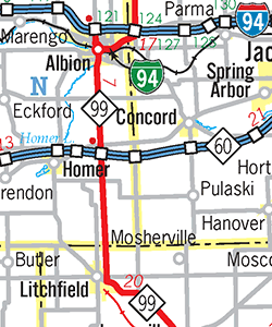 Constructing a new alignment for M-99 between Litchfield and
 | Back to Former M-98 | Route Listings Home | On to M-100 |