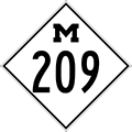
| M-209 is a former state trunkline route existing from October 29, 1932 until June 30, 1995. |
| Southern Terminus*: |
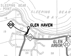
M-109 at the intersection of Dune Hwy & Harbor Hwy just south of Glen Haven in Leelanau Co. |
| Northern Terminus*: |
Glen Haven at cnr Sleeping Bear Dunes Rd |
| Final Length*: |
0.453 mile (2,394.44 feet) |
| Maps: |
 Route Map of Former M-209 Route Map of Former M-209 |
| Notes: |
* The termini and final length for M-209 reflect the beginning and ending of the route and its length as of the time of its decommissioning in mid-1995. |
| |
M-209 was a very short sate trunkline highway spur route connecting the hamlet of Glen Haven within the Sleeping Bear Dunes National Lakeshore to M-109, a looping, scenic alternate to M-22 in the area. However, as of June 6, 1995, MDOT transferred jurisdiction to the Lenawee Co Road Commission and the road, now under local control, is known as Glen Haven Rd and also signed as CR-685 (County Road 685). |
| |
Before its decommissioning in 1995, M-209 held the prize of being the shortest regular state trunkline highway route in the state of michigan, at 0.433 mile or 2,286.24 feet long. |
| |
 Historically, the route of what eventually became M-209 was actually part of M-109 for four years before the east-west portion of that route was eventually added. On October 29, 1932, M-109 was rerouted to run easterly from the Glen Haven area into Glen Arbor. For the purposes of this route listing, it is this date which we are considering to the the official debut date for M-209, although the designation did not start appearing on official and internal State Highway Dept maps until quite some time later. M-209 may not have been physically signed as such for a decade or two after 1932. If that was the case, the 0.433-mile Glen Haven spur may have just been considered by the MSHD as being a third leg of M-109—a phenomenon not completely unheard of at the time. The route was likely signed as M-209 by the late 1940s. Historically, the route of what eventually became M-209 was actually part of M-109 for four years before the east-west portion of that route was eventually added. On October 29, 1932, M-109 was rerouted to run easterly from the Glen Haven area into Glen Arbor. For the purposes of this route listing, it is this date which we are considering to the the official debut date for M-209, although the designation did not start appearing on official and internal State Highway Dept maps until quite some time later. M-209 may not have been physically signed as such for a decade or two after 1932. If that was the case, the 0.433-mile Glen Haven spur may have just been considered by the MSHD as being a third leg of M-109—a phenomenon not completely unheard of at the time. The route was likely signed as M-209 by the late 1940s. |
| |
Many publications from the National Park Service for Sleeping
Bear Dunes National Lakeshore seem to still refer to the former M-209 as being the current designation for the route, even more than twenty years after its removal! Tourists and visitors should be advised there is no longer any physical reference to "M-209" on any area roads. |
| |
In "State Trunkline Needs, 1960–1980," a set of maps prepared by the State Highway Dept's Office of Planning, Programming Division in 1960 showing possible additions, upgrades and improvements to the state trunkline system over the ensuing twenty years, MSHD staff showed the route of M-209 exactly as it was for the 63 years of its existence. The route would continue to exist, unchanged, until its decommissioning 35 years later. |
| |
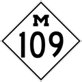 The first two listings in the History section below are for M-109, as it preceeded M-209 as the state trunkline highway route into Glen Haven. Those listings for M-109 are shown with an historic M-109 route marker graphic. The first two listings in the History section below are for M-109, as it preceeded M-209 as the state trunkline highway route into Glen Haven. Those listings for M-109 are shown with an historic M-109 route marker graphic. |
| History: |
1928
(Mar 13) – State Highway Commissioner Fred F. Rogers recommends more than 370 miles of additional state trunkline highway mileage be added to the system as a State Administrative Board meeting. Any mileage added would not be maintained by the state until the following year, however, according to Rogers. Among the 370 miles are the five miles from M-22 north of Empire to Glen Haven. |
| |
1928 (Jun 28) – The new 5.1-mile state trunkline route is determined in southwest Leelanau Co, beginning at M-22 just north of Empire and continuing northerly via present-day Dune Hwy on the west side of Glen Lake, terminating at the hamlet of Glen Haven near D.H. Day State Park. Ironically, the first 4.9 miles of this route were once part of the route of M-22 from 1914–1921, when M-22 was transferred to a new alignment to the east. The newly determined trunkline route is designated M-109. |
| |
1932 (Oct 29) – Just 4½ years later, the road connecting Glen Haven with M-22 at Glen Arbor (present-day Harbor Hwy) is assumed into the state trunkline system as part of M-109, thus making M-109 a loop route off M-22 from just north of Empire to Glen Arbor. At some point, the 0.433-mile spur route from the 90° turn in the route of M-109 just south of Glen Haven is given its own trunkline designation: M-209. It is unclear when M-209 is first signed as its own independent route, however. |
| |
1948 – The first occurrence of the M-209 designation appears on internal State Highway Dept maps and documents. (M-209 may have been signed in the field prior to this or it may not yet be signed in the field.) The first mention of the M-209 route designation in the news media is also mid-1948, so this may have roughly been the time the State Highway Dept first starts signing the route in the field as such. |
| |
1952 (Apr 1) – The M-209 designation makes its debut on the Official Michigan Highway Map. |
| |
1995 (June 30) – All 2,286.24 feet of M-209 from M-109 into Glen Haven are transferred to local control and the M-209 designation is decommissioned. Former M-209 is now simply referred to as Glen Haven Rd. |
| |
2017 (Feb 7) – At its February 7, 2017 meeting, Leelanau Co Road Commission Engineer James Johnson recommends assigning Glen Haven Rd (former M-209) the CR-685 (County Road 685) designation, "in an effort to imporove [road] crew recogntion of primary road status and accuracy of [the Road Commission's] route maintenance reporting." The CR-685 designation mirrors the old M-209 designation for the 0.433 miles from M-109 northerly to the end of the road at Glen Harbor Bay. The former state trunkline was designated as a County Primary Road and a Major Collector (National Functional Classification desination) when it was turned back to local control from state jurisdiction nearly 12 years prior. The board uninmously approves to designated the route as recommended and a CR-685 route marker is posted on Glen Haven Rd just north of M-109 soon after. |
| Controlled Access: |
No portion of former M-209 upon decommissioning existed as freeway or expressway. |
| NHS: |
No portion of former M-209 was on the National Highway System (NHS). |
| Photographs: |
|
| Weblinks: |
|
| |
|