| Western Terminus: |
M-37 (cnr East Beltline Ave & Fulton St) on the east side of Grand Rapids |
| Eastern Terminus: |
I-475/UAW Frwy at Exit 7 in downtown Flint |
| Length: |
99.967 miles |
| Map: |
Route Map of M-21 |
| Notes: |
Prior to the coming of the Interstates, M-21 was a key "Coast-to-Coast" highway in the Lower Peninsula, stretching from Holland on Lake Michigan to Port Huron on Lake Huron, passing through Grand Rapids and Flint en route. After the main north-south "Grand Rapids Expwy" (US-131) was nearing completion through that city, an east-west freeway was proposed with the designation M-21. While the M-21 designation did grace that freeway for a time, it was—and is—more principally known as I-196. The first leg of M-21 to be severed was the Holland-to-Grand Rapids portion, replaced by a completed I-196 freeway in the mid-1970s (with much of the former route re-designated as M-121 in 2007). The next, and bigger, leg to be severed was the Flint-to-Port Huron segment, replaced by I-69 a decade later. Since that time, no major changes to this once-key route have taken place. |
| |
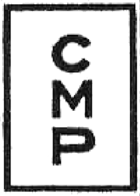  Prior to the designation of state trunklines beginning in 1913, the route of M-21 overlapped almost 100% with one of the many signed Auto Trails of the 1910s. The Central Michigan Pike began at the West Michigan Pike (later M-11, then US-31) at Holland, continued easterly via M-51 (the predecessor trunkline route connecting Holland and Grand Rapids) through Grand Rapids, Ionia, and Saint Johns to Owosso. At Owosso, the CMP continued due easterly toward Flint along present-day M-21, while the original route of M-21 turned southeasterly to run through downtown Corunna and follow Lytle Rd from there to Lennon before jogging back north to the present-day route of M-21. The CMP and M-21 continued easterly through Flint, Lapeer and Imlay CIty, ending in Port Huron. The Central Michigan Pike was signed with markers painted on roadside telephone pholes and other surfaces (fenceposts, sides of barns, etc.)—see image at upper left. In mid-1923, the State Highway Dept agreed with the Central Michigan Pike boosters and rerouted M-21 to run due easterly from Owosso to the Shiawassee/Genesee Co line, coincident with the CMP. As with most other Auto Trails in the state, the Central Michigan Pike faded into obscurity as the 1920s progressed and more motorists began referring to the posted state trunkline routes. The coming of the U.S. Highway system in 1927 was a nail in the coffin for most of the named Auto Trails. Prior to the designation of state trunklines beginning in 1913, the route of M-21 overlapped almost 100% with one of the many signed Auto Trails of the 1910s. The Central Michigan Pike began at the West Michigan Pike (later M-11, then US-31) at Holland, continued easterly via M-51 (the predecessor trunkline route connecting Holland and Grand Rapids) through Grand Rapids, Ionia, and Saint Johns to Owosso. At Owosso, the CMP continued due easterly toward Flint along present-day M-21, while the original route of M-21 turned southeasterly to run through downtown Corunna and follow Lytle Rd from there to Lennon before jogging back north to the present-day route of M-21. The CMP and M-21 continued easterly through Flint, Lapeer and Imlay CIty, ending in Port Huron. The Central Michigan Pike was signed with markers painted on roadside telephone pholes and other surfaces (fenceposts, sides of barns, etc.)—see image at upper left. In mid-1923, the State Highway Dept agreed with the Central Michigan Pike boosters and rerouted M-21 to run due easterly from Owosso to the Shiawassee/Genesee Co line, coincident with the CMP. As with most other Auto Trails in the state, the Central Michigan Pike faded into obscurity as the 1920s progressed and more motorists began referring to the posted state trunkline routes. The coming of the U.S. Highway system in 1927 was a nail in the coffin for most of the named Auto Trails. |
| |
In "State Trunkline Needs, 1960–1980," a set of maps prepared by the State Highway Dept's Office of Planning, Programming Division in 1960 showing possible additions, upgrades and improvements to the state trunkline system over the ensuing twenty years, MSHD staff recommended a massive upgrade to the route of M-21 during that timeframe. While looking back, it's clear the planners were overly ambitious, at the time freeway-building had yet to reach its zenith. In these maps, M-21 was reccommended to be upgraded to a full freeway beginning at the I-96 & I-196 junction east of Grand Rapids, continuing easterly bypass Ada, Lowell, and Saranac to the north, and Ionia, Lyons, Muir, Pewamo, Fowler, St. Johns, Ovid, Owosso, and Corunna to the south, before merging back into its existing alignment at M-13. The existing M-21 along Corunna Rd between M-13 and Linden Rd would be converted to freeway, with the freeway then angling southeasterly to an interchange with I-75/US-10/US-23 in the vicinity of the Miller Rd interchange. Under these planas, M-21 would then transition to what is now I-69 (which was largely built as the M-21 freeway from the 1960s to the 1980s) from Flint to Port Huron, featuring proposed BUS M-21 routings at Flint, Lapeer and Imlay City (none of which were ever designated). |
| History: |
1913 – The initial route earmarked for Trunk Line 21 (T.L. 21), which would become the signed route M-21 in the future, was the Ionia–Saint Johns–Owosso–Flint–Lapeer–Goodells route across much of the lower third of the Lower Peninsula. |
| |
1913 (July 22) – The first two segments of Trunk Line 21 (T.L. 21) to be officially established as a state trunkline highway are the portions in Genesee Co outside the City of Flint. Specifically, the western segment begins at Sheridan Rd (present-day M-13) on the Shiawassee Co line and continues easterly along Corunna Rd for 10.9 miles to approximately 200 feet east of Clancy Ave on the western edge of Flint. The east segment begins at Howard Ave on the east side of Flint and continues easterly along Lapeer Rd for 10.9 miles to the Lapeer Co line. |
| |
1913 (Sept 11) – Less than two months later, T.L. 21 in Shiawassee Co is officially established except the portions in the cities of Owosso and Corunna. Specifically, the segments are:
- A 10.0-mile section from the Clinton Co line at Ovid easterly, southerly and easterly along Elm Rd, then easterly for a short distance on present-day M-21, southerly via Warren Rd, easterly, southerly and easterly again along Simpson Rd, northerly on Ruess Rd, then easterly along present-day M-21 to the Owosso west city limit at Chestnut St.
- The 1.0-mile portion of Corunna Ave (present-day M-71) from the Owosso east city limit easterly to the Corunna west city limit.
- A 10.5-mile segment from the Corunna east city limit easterly along Lytle Rd into the Village of Lennon, then northeasterly on Lennon Rd to Sheridan Rd (present-day M-13), then northerly on Sheridan Rd to Corunna Rd north of Lennon.
|
| |
1913 (Oct 13) – One month later, the portion of T.L. 21 in Ionia Co is officially established outside of the portions in incorporated communities. Beginning at the Ionia city limit on the Cleveland St bridge over the Grand River, T.L. 21 heads southerly on Kelsey Hwy, then easterly via Riverside Dr to the Lyons west village limit. Then from the Lyons east village limit, T.L. 21 is established following Kimball Rd, then northeasterly on Stoney Creek Rd (using a bridge to cross the Grand River which no longer exists in present-day), then northerly along Hubbardston Rd to the Pewamo south village limit. |
| |
1913 (Nov 15) – Inexplicably, the 10.9-mile portion of T.L. 21 along Lapeer Rd from Howard Ave in Flint easterly passing to the south of Davison to the Genesee/Lapeer Co line is cancelled as a state trunkline route with no replacement route at this point. |
| |
1913 (Nov 26) – Eleven days later, another seemingly inexplicable change to T.L. 21 in Ionia Co ocurs when the 5.0-mile segment along Kelsey Hwy and Riverside Dr from the Grand River on the Ionia city limit easterly to the Lyons west village limit is cancelled as a state trunkline route. However, simultaneously, the same roadways are immediately re-established as a 5.0-mile trunkline route with the same termini. |
| |
1914 (Apr 8) – T.L. 21 across Clinton Co is officially established as a state trunkline, with the exceptions of the portions within the incorporated communities—Fowler, Saint Johns and Ovid—along the way, for a total of 20.7 miles. |
| |
1915 (Nov 27) – The first section of T.L. 21 in Lapeer Co is officially established from the Genesee Co line easterly and northeasterly via Genesee Rd to the Lapeer west city limit at Millville Rd. |
| |
1916 (Oct 3) – In a reversal of (most) of the cancellation of the portion of T.L. 21 in Genesee Co east of the City of Flint, the 10.4-mile segment of Lapeer Rd from Barks St in the eastern part of Flint easterly to the Lapeer Co line is re-established as a state trunkline route. This re-establishes 10.4 miles of the 10.9 mile route cancelled in mid-November 1913. |
| |
1919 (June 26) – A 1.5 mile segment of T.L. 21 is officially established through the City of Saint Johns in Clinton Co following State St from the west city limit easterly to Scott Rd on the east city limit. |
| |
1919 (July 21) – Less than a month later, the route of T.L. 21 in the two villages in eastern Ionia Co along its route is established. In Lyons, Riverside Dr from the west village limit easterly, then northerly along Libhart St, and easterly again via Bridge St to the east village limit is established. In Pewamo, the established route starts on the south village limit and heads northerly via State St (Hubbardston Rd), then easterly along Main St to the east village limit (also the Ionia/Clinton Co line). |
| |
1919 (Oct 30–31) – T.L. 21 is extended easterly from Lapeer into St Clair Co in four segments:
- T.L. 21 is designated along the existing T.L. 36 (established August 21, 1916) from the Lapeer east city limit easterly along Bowers Rd to Lake Pleasant Rd where T.L. 36 turns northerly.
- T.L. 21 is then established along a 6.5-mile section from T.L. 36 at Bowers Rd southerly via Lake Pleasant Rd to Attica, then easterly along Attica Rd, southerly on Summers Rd and easterly again via Attica Rd to Blacks Corners Rd on the Imlay City west city limit.
- A 4.3-mile section of T.L. 21 is established from T.L. 53 at Almont Ave on the north side of Imlay City, then easterly via Imlay City Rd to the Lapeer/St Clair Co line.
- T.L. 21 is extended for 17.75 miles into St Clair Co from Cade Rd on the Lapeer Co line easterly along Imlay City Rd, southerly via Capac Rd–Main St into downtown Capac, then easterly on Mill St–Bryce Rd, southerly via Emmet Rd, southwesterly on Kinney Rd into Emmet, then easterly via Brandon Rd to a terminus at T.L. 19 at Kilgore Rd north of Goodells.
|
| |
1919 (Dec 20) – A 0.5-mile extension of the route of T.L. 21 occurs on the west side of Owosso in Shiawassee Co when the portion of W Main St from Chestnut St on the west city limit easterly to Chipman St is officially established. |
| |
1920 (Jan 20) – A good portion of the route of T.L. 21 in the City of Lapeer is established in two segments. Beginning on the west city limit, a 1.65-mile segment is established easterly along Genesee St, jogging northerly for one block via Main St, then northeasterly on Nepessing St to Higgins St on the edge of the downtown area. The second 0.7-mile segment (concurrently with T.L. 36) begins at Saginaw St and continues northeasterly along Nepessing St to Oregon St, then easterly via Oregon St to the east city limit. |
| |
1920 (Apr 15–30) – T.L. 21 is signed in the field as M-21 as all state trunkline highways in the Lower Peninsula are scheduled to be signed with route markers during the last half of April. |
| |
1920 (May 4–21) – Two sections of M-21 in Flint are officially established. First, an additional 0.75-mile section of the route of M-21 on the west side of Flint is established on May 4 along Corunna Rd from a point approximatly 200 feet east of Clancy Ave northeasterly to Court St. Then on May 21, the 0.5 mile portion of Lapeer Rd on the east side of Flint is re-established as a state trunkline route from Howard Ave easterly to Barks St—the westernmost ½ mile portion of the 10.9-mile segment of Lapeer Rd which was established on July 22, 1913 and cancelled on November 15 of the same year. |
| |
1920 (July 23) – The 1.5-mile portion of M-21 in the City of Saint Johns in Clinton Co which was established almost exactly one year earlier on July 26, 1919 is cancelled as a state trunkline route, while the easternmost and westermost portions of that segment are immediately re-established. From the west city limit, the 0.55-mile portion of State St is re-established continuing easterly to Ottawa St, while the 0.45-mile segment of State St from Whittemore St easterly to Scott Rd on the east city limit is also re-established. (M-21 remains designated along the ½ mile section of State St through downtown, it just happens to be under city jurisdiction at this point.) |
| |
1920 (Dec 21) – Although M-21 was established along a straight path from Saint Johns easterly to just west of Ovid in 1914, one mile of that path was along a roadway which had yet to be constructed. At this point, the one mile segment of the established route between St Clair and Shepherdsville Rds is cancelled as a state trunkline, while an existing roadway between those points is established as the new trunkline route. At St Clair Rd, M-21 now turns northerly for ¼ mile via St Clair to Winfield Rd, then easterly via Winfield Rd into Shepherdsville. There, M-21 now turns back southerly along Shepherdsville Rd for ¼ mile back to its existing route. It is likely this 1.5-mile "detour" route has been signed and maintained as part of M-21 and this change now makes it official. |
| |
1921 (Jan 4) – The 2.5-mile section of M-21 through the City of Corunna in Shiawassee Co is officially established, entering the city from the west via Corunna Ave, continuing easterly to Shiawassee Ave, southerly along Shiawassee Ave, then easterly again via McNeil St to the east city limit. |
| |
1921 (Jan 21) – Seventeen days later, the 1.0-mile route of M-21 through the Village of Fowler in Clinton Co is also officially established along 2nd St from the west village limit to the east village limit. |
| |
1923 (July 10) – As detailed in the Notes section above, the State Highway Dept announces that M-21 will be rerouted in Shiawassee Co from Owosso easterly to the Genesee Co line via the exisitng route of the Central Michigan Pike, one of dozens of named Auto Trails, precursors to the numbered and signed state trunkline route system. Although annouced, the rerouting of M-21 won't be completed for a year while it won't be officially established as a state trunkline route for two years. |
| |
1923–24 – The straight-line route for M-21 from Owosso easterly to the Shiawassee/Genesee Co line, bypassing Corunna to the north, which the State Highway Dept announced in mid-1923 is completed and paved in two stages. First, from the Owosso east city limit easterly three miles to Escott Rd at the northeast corner of the CIty of Corunna in 1923, while the remaining 8½ miles from Escott Rd to Sheridan Rd on the county line north of Lennon is completed in 1924. The former route of M-21 from Owosso southeasterly through downtown Corunna, then easterly along Lytle Rd to Lennon, then northerly along Sheridan Rd from Lennon to M-21 at Corunna Rd is redesignated as a double-headed extension for M-71. (M-71 had previously been a 3½ mile trunkline spur from M-21/Lytle Rd southerly along Durand Rd into downtown Durand. M-71 now becomes a three-legged route With a northwestern terminus at M-21 in Owosso, a northeastern terminus at M-21 a mile north of Lennon and the original southern terminus at Durand. Three-legged routes are not completely unknown in this timeframe.) |
| |
1925 (June 16, Sept 1) – The previous route of M-21 along a 6.5-mile stretch of Lytle Rd from the Corunna city limit easterly to Durand Rd north of Durand—which had recently become the "northwest" leg of M-71—is cancelled on June 16 as a state trunkline route, being replaced by a new more direct routing for M-71 through Vernon. Then on September 1, the 11.6-mile due east-west section of M-21 from Owosso easterly to the Genesee Co line announced by the State Highway Dept in 1923 is officially established as a state trunkline highway route, even though it's been open to traffic for at least a year at this point. |
| |
1925 (Sept 1)  – After a year spent wrangling with Ionia Co officials on the funding for a realigment for M-16 directly west from the Portland area via Grand River Ave into Kent Co and then northwesterly into Grand Rapids, cutting 10–12 miles from the existing route of M-16 (which has turned northerly west of Portland to run into Ionia where it then follows the Grand River through Saranac and Lowell and into Grand Rapids via Ada), a method is reached on a funding mechanism for the new direct route of M-16. The new route for M-16 along Grand River Ave (Cascade Rd in Kent Co) is established as a state trunkline, with the former route of M-16 from Ionia westerly through Saranac, Lowell and Ada to a point between Ada and East Grand Rapids becoming a westerly extension for M-21. This new westerly extension adds more than 28 miles to the length of M-21. – After a year spent wrangling with Ionia Co officials on the funding for a realigment for M-16 directly west from the Portland area via Grand River Ave into Kent Co and then northwesterly into Grand Rapids, cutting 10–12 miles from the existing route of M-16 (which has turned northerly west of Portland to run into Ionia where it then follows the Grand River through Saranac and Lowell and into Grand Rapids via Ada), a method is reached on a funding mechanism for the new direct route of M-16. The new route for M-16 along Grand River Ave (Cascade Rd in Kent Co) is established as a state trunkline, with the former route of M-16 from Ionia westerly through Saranac, Lowell and Ada to a point between Ada and East Grand Rapids becoming a westerly extension for M-21. This new westerly extension adds more than 28 miles to the length of M-21. |
| |
1925 (Sept 1) – A new route for M-21 at Emmett in central St Clair Co is officially established along Emmett Rd from Kinney Rd due southerly to a large wye intersection at the existing route of M-21 on Brandon Rd in Emmet. The former route of M-21 along Kinney Rd between Emmett Rd and Brandon Rd is not cancelled and turned back to local control, however, but is retained to be used as a new routing for M-19 in the next two years. |
| |
1926 (May 19) – A new alignment for M-21 from just west of Ovid in Clinton Co easterly to west of Owosso in Shiawassee Co is officially established as a new trunkline route for M-21 in two segments, although construction on the new route has not yet commenced. The segments are:
- From Hollister Rd in Clinton Co approximately ¾ mile southwest of Ovid (as the crow flies) then easterly 1.6 miles into Shiawassee Co to Elm Rd where it merges back into the existing route of M-21 southeast of Ovid.
- Then from Warren Rd approximately 1½ miles east of Ovid easterly 4.7 miles to Ruess Rd, approximately 3¾ miles west of downtown Owosso.
Similarly, the existing route of M-21 between those same points is cancelled as a state trunkline route, although it is retained as a "marked-and-maintained" route for the time being until the new alignment is complete and opened to traffic. The cancelled segments are:
- From the cnr of M-21 & Hollister Rd southwest of downtown Ovid, then northerly via Hollister Rd, easterly along Front St through Ovid, southerly on East St, then southeasterly in a stairstep fashion via Elm Rd into Clinton Co where it meets the newly-established M-21 route 0.62 mile west of Warren Rd.
- From the cnr of M-21 & Warren Rd, southerly along Warren Rd, easterly via Simpson Rd, jogging southerly at Austin Rd and then easterly again still along Simpson Rd, then northerly via Ruess Rd back to the newly-established M-21 route at present-day M-21 about one mile west of Five Points.
|
| |
1926 (Nov) – After several proposals and a bit of political wrangling on the actual numbering and routes, the U.S. Highway system is announced, with 13 new national route designations destined for Michigan. Due to this, several state highway designations across the state are changed and M-51 running between Holland and Grand Rapids is earmarked to be replaced in its entirety by a westerly extension of M-21 from Grand Rapids to Holland, adding 33 miles to the route. (The M-51 route designation will be used to replace the M-27 designation in the Thumb, as US-27 is one of the new U.S. Highways coming to the state.) |
| |
1927 (May 15) – The various state trunkline designation changes due to the debut of the U.S. Highway system in the State of Michigan become official as to the many modifications to other routes affected by those changes. The M-21 extension from east of Grand Rapids through Grandville, Hudsonville and Zeeland to Holland over the former route of M-51 is one of those changes to become official today. M-21 is posted to run concurrently with the new US-16 (previously M-16) from its previous western terminus at cnr Cascade Rd & Forest Hill Ave westerly through downtown Grand Rapids, then southwesterly along its new route. Additionally, M-19 is rerouted to run southerly from Brockway, through Emmett (where it intersects M-21 now), and via Memphis and Richmond to its former route, now part of US-25 along Gratiot Ave. As such, M-21 is also extended on its eastern end by approximately 13 miles from Kilgore Rd east of Emmett via Lapeer Rd (formerly M-19) through Wadahms to the Port Huron west city limit at M-146/24th St.
Interestingly, on July 1, 1924, a new route for M-19 between Goodells and Port Huron in east-central St Clair Co was established along Lapeer Rd and the former route via Goodells Rd, Sparling Rd and Griswold Rd was cancelled as a trunkline route. However, M-19 remained signed along the former route which remained a "marked-and-maintained" route ever since with the Lapeer Rd route not signed as M-19. As such, with the redesignation of the easternmost 14 miles of M-19 from Goodells into Port Huron as M-21, the Goodells–Port Huron portion of the signed route is now a "marked-and-maintained" highway and the officially-established route runs via Lapeer Rd, although it is not signed as such. |
| |
1925 (Sept 1) – A new route for M-21 at Emmett in central St Clair Co is officially established along Emmett Rd from Kinney Rd due southerly for 0.62 mile to a large wye intersection at the existing route of M-21 on Brandon Rd in Emmet. The former route of M-21 along Kinney Rd between Emmett Rd and Brandon Rd is not cancelled and turned back to local control, however, but is retained to be used as a new routing for M-19 in the next two years. |
| |
1927 (June 30) – The existing 0.6-mile municipally-maintained route of M-21 into Imlay City from the west is officially established as a state trunkline route beginning at the cnr of Attica Rd & Blacks Corners Rd, southerly via Blacks Corners Rd then easterly along Fourth St to M-53/Almont Ave downtown. |
| |
1928 (May 2) – A 1.0-mile segment of new state trunkline highway is officially established as a new route for M-21 running due easterly from its existing route at Saint Clair Rd in Clinton Co's Ovid Twp connecting back with its existing route at Shepardsville Rd at the community of Shephardsville, approx three miles west of Ovid. The former route of M-21 along Saint Clair Rd northerly ¼ mile to Winfield Rd, then easterly along Winfield into Shepardsvile, then southerly via Shepherdsville Rd ¼ mile back to the new M-21 route is officially cancelled as a state trunkline route and turned back to county control. |
| |
1928 (Aug) – As part of an overall effort to route M-21 from Grand Rapids easterly through Kent and Ionia Cos onto a more direct and updated alignment, the first segment in this effort is completed and opened to traffic from the east limits of Grand Rapids easterly via and upgraded E Fulton St to the community of Ada, merging back with the former route of M-21 at the western end of bridge spanning the Grand River. This new alignment consists both of upgrades to existing roadways as well as some segments of new highway alignments. The former route of M-21 departing Grand Rapids to the east via US-16/M-50 along the Lake Dr–Robinson Rd–Cascade Rd route easterly to Forest Hill Ave retains the US-16 and M-50 designations, while 4.1 miles of Ada Dr from US-16/M-50/Cascade Rd northerly to Ada Dr and Ada Dr easterly from Forest Hill through the community of Ada to the western end of the Grand River bridge is temporarily retained as an unsigned staet trunkline route. |
| |
1928 (Oct 30, Dec 18–19) – The effort to route M-21 from Grand Rapids easterly through Kent and Ionia Cos onto a more direct and updated alignment continues when a second segment is completed and opened to traffic in a major ceremony held at Lowell on October 30. Local, regional and statewide dignitaries celebrated the completion of the new alignment of M-21 along E Fulton St (in Kent Co) and Bluewater Hwy (in Ionia Co) from Lowell easterly into Ionia Co to Hawley Rd at Saranac where it turned southerly to cross the Grand River to resume its previous alignment on the south side of the river between Saranac and Ionia. A related 1.1-mile long realignment project on the west side of Lowell completes the project moving M-21 onto a more direct alignment between Alden Nash Ave and West Ave, when local farmer D. G. Mange who had, according to the Lowell First Look, "previously said he would not consent to splitting his farm on the southeast quarter of Sec. 3 for M-21 to cross, relented and agreed to allow the crossing." While the new alignment opens to traffic at the end of October, official establishment as a trunkline doesn't take place until December 18 when the 1.1 mile of W Main St on west side of Lowell from Alden Nash Ave to West Ave is officially established as a state trunkline route for M-21 and Bowes St from Alden Nash Ave easterly to West Ave and West Ave itself are canceled and turned back to local control. From Lowell easterly, E Main St in Lowell from Washington St to the east city limit as well as E Fulton St from there to the Ionia Co line is established as a state trunkline highway route. In Ionia Co, Bluewater Hwy on the north side of the Grand River from the Kent Co line easterly for 12.7 miles past Saranac to M-44/Haynor Rd west of Ionia is similarly officially established as the route of M-21 a day later on December 19, although only the section between Lowell and Hawley Rd at Saranac is complete and open to traffic. The remainder of the new route for M-21 north of the Grand River between Saranac and Lowell is still incomplete and M-21 remains on its former alignment via Riverside Dr as a "marked-and-maintained" route for the time being. This is because the 1.0-mile of Grand River Dr in Kent Co from S Division St at Lowell easterly to the Kent/Ionia Co line at Montcalm Ave as well as the 12.3 miles of Riverside Dr in Ionia Co from Montcalm Ave easterly to M-43/State Rd (present-day M-66) south of Lowell and the 1.3-mile Summit St–Bridge St–Main St routing through Saranac are all cancelled as a state trunkline highway route and officially turned back to local control on December 18. |
| |
1928 (May 2) – The one-mile gap in the straight-line route of M-21 between Saint Johns and Ovid at Shepherdsville is officially established as a state trunkline route (as it had been from April 1914 until December 1920) between St Clair Rd and Shepherdsville Rd about three miles west of Ovid. The new mile-long segment of highway is not yet complete, though, but will open along with the new segment of M-21 from west of Ovid easterly toward Owosso in the fall. The former route of M-21 along St Clair, Winfield and Shepherdsville Rds is officially cancelled as a state trunkline route, but retains its M-21 markers until the new highway is completed. |
| |
1928 (Sept 30) – The new sections of M-21 established from west of Ovid to west of Owosso are constructed using convict labor during the 1928 construction season and completed and opened to traffic on September 30. Also included is the former one-mile gap in the straight-line route between Saint Johns and Ovid which was established almost five months prior. The newly-constructed roadway consists ot a two-lane, 20-foot wide pavement and replaces the former route (cancelled in May 1926) which included nearly twenty curves. The new route features just one very gentle reverse curve at the Clinton/Shiawassee Co line. The dedication for the new route is attended by Governor Fred W. Green, State Highway Commissioner Frank F. Rogers, Deputy State Highway Commissioner G.C. Dillman, Superintendant of the State Construction Dept (and future State Highway Commissioner) Charles Ziegler, several other state leaders, the Lansing Mayor, Clinton and Shiawassee Co Road Commission leaders, and many other local civic leaders. A luncheon in Saint Johns preceeds the official opening while a dinner in Owosso follows, both of which are sponsored by the respective cities Chambers of Commerce. |
| |
1928–29 – A project to relocate M-21 heading easterly from Flint to Lapeer involves a rather complex set of trunkline establishments, cancellations, and re-establishments as well as a mix of upgrading existing local roads and new construction. In basic terms, until now, M-21 has departed Flint via Lapeer Rd, following that road all the way to its namesake city, but the State Highway Dept has decided to upgrade Davison Rd, running roughly parallel to and north of Lapeer Rd, easterly from Flint, through Davison and merging back into the existing route of M-21 just west of Lapeer. However, the complete—and often confusing—list of events for this project includes:
- June 27–28, 1928 (Estab.) – A new 14.8-mile long state trunkline route from the Flint east city limit at Center Rd eastery through Davison to a point on Genesee Rd approximately 0.1 mile west of the Lapeer west city limit at Millville Rd is officially established as the new route for M-21. Between Flint and the Genesee/Lapeer Co line, the new trunkline follows Davison Rd. In Lapeer Co, the new route turns northeasterly for 0.6 mile on a roadway to be constructed, then runs easterly along an existing county road for nearly a mile to Maple Leaf Rd. From there almost due easterly for 3½ miles, the new trunkline route follows a yet-to-be built roadway before merging back into existing M-21/Genesee Rd just west of the Lapeer city limit. The 8.8-mile Genesee Co portion is established on June 27, while the 6.0-mile Lapeer Co portion is established the next day on June 28.
- June 27–28, 1928 (Canc.) – Simultaneously to the new establishment (above), the 17.1-mile route of M-21 from Howard Ave in Flint easterly into Lapeer Co to just west of the Lapeer city limit where the new M-21 trunkline route will merge into the existing highway is cancelled as a state trunkline route, although M-21 route markers remain and the route is a "marked-and-maintained" facility until the new trunkline route is completed and opened to traffic. The cancellation of Lapeer Rd, as with the establishments along Davison Rd, take place on June 27 in Genesee Co and on June 28 in Lapeer Co.
- July 18, 1928 (Canc.) – Oddly, the 5.9-mile portion of the newly-established M-21 route along Davison Rd from the Flint east city limit easterly to M-15/State St in Davison (approximatley 40% of the segment) is cancelled as a state trunkline route just three weeks after being established, even before construction on the route is completed or it is even signed as part of M-21! Why this part of the newly-established route is almost immediately cancelled is unclear.
- July 18, 1928 (Re-Estab.) – Even more odd, the 6.8-mile section of Lapeer Rd from US-10/Dort Hwy in Flint easterly to M-15/State Rd south of Davison is re-established as a state trunkline route. Just three weeks after Lapeer Rd in its entirety was cancelled, the western 40% of that cancelled trunkline is almost immediatelu re-established!
- August 30, 1928 – The 0.5-mile portion of Flint St (the portion of Davison Rd within the Davison city limit) from M-15/State St westerly to the Davison west city limit is re-established as a state trunkline route... after having been part of the 5.9-mile cancellation on July 18... after having been part of the 14.8-mile establishent on June 27! So, in just over two months, this ½ mile segment of Davison Rd/Flint St has been established as part of M-21, cancelled as a state trunkline and now re-established... but only this ½ mile portion!
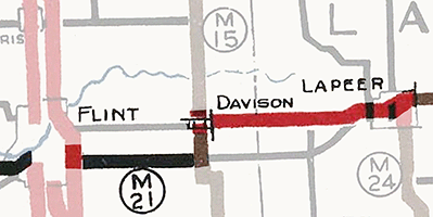 October 1928 – The portion of rerouted M-21 along Davison Rd from M-15/State St in Davison easterly into Lapeer Co to where it merges back with the former M-21 on Genesee Rd just west of Lapeer is completed and opened to traffic. With most of the Flint–Davison section of Davison Rd having been cancelled as a trunkline route (after having been established for just three weeks in the Summer), M-21 is routed east out of Flint via Lapeer Rd to M-15/State Rd, then northerly with M-15 into Davison, then easterly again on the newly-completed Davison Rd route into Lapeer Co and on to Lapeer. October 1928 – The portion of rerouted M-21 along Davison Rd from M-15/State St in Davison easterly into Lapeer Co to where it merges back with the former M-21 on Genesee Rd just west of Lapeer is completed and opened to traffic. With most of the Flint–Davison section of Davison Rd having been cancelled as a trunkline route (after having been established for just three weeks in the Summer), M-21 is routed east out of Flint via Lapeer Rd to M-15/State Rd, then northerly with M-15 into Davison, then easterly again on the newly-completed Davison Rd route into Lapeer Co and on to Lapeer.- January 28, 1929 – Then a little more than six months after having been cancelled (having only been established for three weeks), the 4.9-mile segment of Davison Rd from Covert Rd in Flint easterly to the Davison west city limit is re-restablished as a state trunkline route! The parallel state trunkline route on Lapeer Rd to the south also remains a state trunkline highway.
- Mid-1929 – The Davison Rd routing for M-21 seems to be completed and opened to traffic—and signed as M-21—all the way from Flint, easterly through Davison and to Lapeer. With the final relocation of M-21 to the Davison Rd corridor, the former route of M-21 along Lapeer Rd from US-10/Dort Hwy in Flint easterly to M-15/State Rd south of Davison is redesignated as M-21A. The M-21A designation is routed northerly from each end of this Lapeer Rd segment along both US-10/Dort Hwy and M-15/State Rd to form a complete alternate loop off M-21.
|
| |
1929 (Jan 3) – Ever since the direct state trunkline route was completed between Zeeland and Hudsonville in Ottawa Co was completed along the Pere Marquette Ry (later C&O, then Chessie System and now CSX) line, initially designated as part of M-51 and then redesignated as part of M-21 in 1927), a troublesome sinkhole has plagued a short, 0.3-mile segment near Vriesland Station, where the Black River (present-day Macatawa River) crosses the highway approximately three miles northeast of Zeeland. A wooden bridge was constructed spanning the sinkhole in 1925, but also featured a dangerous curve which was the site of many bad accidents. Construction on a new 60-foot bridge over the sinkhole, costing $28,475, began on July 1 and required four pairs of caisson piers of reinforced concrete sunk 45 feet to bedrock. The opening of the new bridge removes the curves in the route and places the highway on a more permanent structure. While the approaches to the concrete bridge are still gravel surfaced, the entire 0.3-mile segment of highway will be paved with concrete in the future. |
| |
1929 (June 6) – While it opened to traffic the previous August, the new 8.2-mile segment of M-21 between Grand Rapids and Ada in Kent Co following the Fulton St alignment is officially established as a state trunkline highway route from Carleton Ave in Grand Rapids easterly to the western end of the Grand River bridge at Ada. The 4.1-mile long former segment of M-21 along Forest Hill Ave from US-16/M-50/Cascade Rd northerly to Ada Dr and Ada Dr easterly from Forest Hill through Ada to the new M-21/Fulton St is cancelled as a state trunkline highway route and turned back to county control. The approx ¼ mile portion of the former route of M-21 from the cnr of Ada Dr & E Fulton St easterly to the western end of the Grand River bridge is abandoned as a public roadway. |
| |
1929 (Aug 26) – A new 3.878-mile long route for M-21 between Holland and Zeeland is officially established as a state trunkline route, although construction on the new link has not yet begun. As such, the existing 4.0-mile section of M-21 starting at the Holland east city limit easterly via Eighth St, then northeasterly along Holland-Zeeland Rd (Paw Paw Dr) and then easterly on W Main Ave to Colonal St in Zeeland is cancelled as a state trunkline highway, but is retained as a "marked-and-maintained" route until the new highway is completed and opened to traffic. (M-21 also remains signed along Main Ave through downtown Zeeland to Carleton Ave where it turns northerly along Carleton then northeasterly alongside the Pere Marquette Ry tracks toward Hudsonville.) The newly-established route departs Eighth St at the Holland east city limit and follows present-day Chicago Dr to the Zeeland west city limit where it jogs northeasterly for a blocks, then continues easterly along Washington Ave to Colonial St. |
| |
1929 (Nov 25) – While actual work is far from complete, another segment in the overall project to move M-21 from the south side of the Grand River through Ionia Co to the north side takes a step forward when a new 10.8-mile long trunkline route is officially established from the point where E Lincoln Ave in Ionia leaves the east city limit and continues generally easterly bypassing Muir to the north and continuing east to bypass Pewamo to the south before merging back into the existing route of M-21 approx 350 feet east of the Ionia/Clinton Co line. The former route from the Cleveland St bridge spanning the Grand River at Ionia southerly via Cleveland to Riverside Dr, then easterly along Riverside Dr to Lyons, through Lyons via Libhart St and Bridge St, then easterly from Lyons via Kimball Rd then Stoney Creek Rd to Hubbardston Rd, northerly on Hubbardston Rd into Pewamo continuing north along State St to Main St downtown Pewamo, then easterly along Main St to approx 350 feet east of the Ionia/Clinton Co line is officially cancelled as a state trunkline highway route and turned back to local control—except that since the new alignment is not yet complete, the former route remains signed as a "marked-and-maintained" route of M-21. |
| |
1930 (Aug 28) – An approximately 7½ mile segment of relocated M-21 is completed and (unofficially) opened to traffic in Ionia Co along Bluewater Dr from Hawley Rd to Hayor Rd on the western edge of Ionia, running north of the Grand River. This completes a project which saw the new portion of M-21 from Lowell easterly to Saranac opened to traffic in late October 1928. While this segment had been officially established as a trunkline route in mid-December 1928, it takes almost two additional years for the Saranac–Ionia segment to be completed. In the interim, the former route of M-21 along Riverside Dr south of the river remained signed as a "marked-and-maintained" route even though it had been officially cancelled as a trunkline route. M-21 now stays on the north side of the Grand River from Ada all the way through Lowell to Ionia. While traffic begins using the new route of M-21 between Saranac and Ionia in late August, it's official opening by the State Highway Dept doesn't come for another month or two later. |
| |
1930 (Dec 2) – In a minor bit of foreshadowing of a major highway rerouting in Lapeer Co, the 1.0-mile portion of M-21 along Lake Pleasant Rd from Bowers Rd southerly to Imlay City Rd is cancelled as a state trunkline route, although it remains a "marked-and-maintained" route signed as part of M-21 for the time being. |
| |
1931 (Jan 3) – Months prior to the passage of the Dykstra Ave (Act 131 of 1931), a 0.9-mile long segment of Washington Ave in Zeeland running parallel to and one block north of existing M-21 through the downtown is officially established as a state trunkline route in preparation for the completion of the new Holland–Zeeland highway segment currently under construction. The newly-established segment runs from the east end of the trunkline established in late-August 1929 on Washington Ave at Colonial St and continues easterly along Washington Ave to just east of Carlton Ave, which is the existing route of M-21 exiting Zeeland. M-21 route markers are not yet erected along this route until the new Holland–Zeeland section is completed later in the year. |
| |
1931 (May 19) – Act 131 of 1931—the Dykstra Act—is passed allowing the State Highway Dept to take over control of state highways running into and through incorporated cities, thereby officially incorporating them as state trunkline highways. The following segments of formerly city-controlled streets are assumed into the system as part of M-21:
- In Holland: 0.8 mile of Eighth St from US-31/River St downtown (the western terminus of M-21) easterly to the east city limit at Fairbanks Ave.
- Through Grand Rapids: The 4.1-mile portion of M-21 through the city from the west city limit at Clyde Park Ave, northeasterly via Grandville Ave, then easterly along Franklin St, northerly on Eastern Ave, then easterly to Carlton Ave on the eastern side of the city.
- Through Lowell: The 0.4-mile segment of Main St from M-66/Hudson St easterly through downtown to Washington St.
- Through Saint Johns: The 0.5-mile portion of State St from Ottawa St easterly to Whittemore St, concurrently with US-27.
- Through Owosso: The 1.5-mile section of M-21 along Main St from Chipman St easterly through downtown to the east city limit at Gould St.
- Through Flint: The 4.0-mile portion of M-21 in two segments:
- The 3.0 miles along Court St from Corunna Rd easterly through downtown to US-10/Dort Hwy, and
- The 1.0-mile portion of Davison Rd from US-10/Dort Hwy easterly to Center Rd.
- In Port Huron: The 1.4-mile segment of Lapeer Ave from M-146/24th St easterly to US-25/M-29/Military St, the eastern terminus of M-21.
|
| |
1931 (July 5) – The 3.878-mile long segment of M-21 established between Holland and Zeeland in late-August 1929 is completed and opened to traffic. The new 20-foot wide highway departs Eighth St at the Holland east city limit and follows present-day Chicago Dr to the Zeeland west city limit where it jogs northeasterly for a blocks, then continues easterly along Washington Ave to Colonial St. From that point, M-21 is now signed along Washington Ave easterly bypassing downtown Zeeland on the 0.9-mile section of state trunkline established seven months earlier to Carleton Ave where it merges back into the previous route of M-21 through the city. The former route of M-21 from the Holland east city limit easterly via Eighth St, then northeasterly along Holland-Zeeland Rd (Paw Paw Dr) and then easterly on W Main Ave to Colonal St in Zeeland had been cancelled as a trunkline in August 1929 as well, but has been "marked-and-maintained" as M-21 until now. |
| |
1931 (Aug 10–September) – The 1.4-mile segment of Lincoln Ave in Ionia from M-14/Dexter St (present-day M-66) easterly to the Ionia east city limit is established as a state trunkline route for M-21 on August 10, connecting with the 10.7-mile portion between Ionia and Pewamo established in late 1929. Until now, M-21 has been routed through downtown Ionia Main St easterly to Cleveland St, then southerly via Cleveland St across the Grand River and then easterly through Lyons to Pewamo. Then in September, the new Ionia-to-Pewamo section of M-21 (the segment established in late 1929) is completed and opened to traffic from the Ionia east city limit easterly past Muir to the Ionia/Clinton Co line, with the exception of the Pewamo bypass. The Grand Trunk Railway viaduct just west of Pewamo is not yet complete, so M-21 is temporarily routed through the village from the west via Pewamo Rd–W Lincoln St to State, southerly one block (crossing the railroad) along State St to Main St, then easterly out of Pewamo via the former route of M-21 on E Main St. The former route of M-21 on the south side of the Grand River between Ionia and Pewamo had been cancelled as a trunkline in late November 1929, but has remained as a "marked-and-maintained" route until now. |
| |
1931 (Aug 31, Sept 30–Oct 25) – A new 12.2-mile route for M-21 between Lapeer and Imlay City in central Lapeer Co is officially established on August 31. All but one mile of the former 14.2-mile route between those two cities—specifically Nepessing St in Lapeer from Saginaw St northeasterly, Oregon St and Bowers Rd easterly to Lake Pleasant Rd, Lake Pleasant Rd from Imlay City Rd southerly to Attica, Attica Rd easterly, Summers Rd southerly, Attica Rd easterly, Blacks Corners Rd southerly and Fourth St (in Imlay City) easterly to M-53/Almont Ave—is cancelled as a trunkline route. (For whatever reason, the one-mile stretch of M-21 along Lake Pleasant Rd from Bowers Rd southerly to Imlay City Rd was cancelled in December 1930.) However, until construction is complete and the new route open to traffic, M-21 remains a "marked-and-maintained" route along the cancelled trunkline highway. Then on September 30, the eastern portion of the new highway along Imlay City Rd from Lake Pleasant Rd near Attica easterly to Almont Ave in Imlay City is completed and opened to traffic. Nearly a month later on October 25, the remainder of the realigned route along Imlay City Rd from Saginaw St in Lapeer easterly to Lake Pleasant Rd near Attica is completed and opened, completing the realignment between Lapeer and Imlay City. This was also the final major segment of M-21 to be paved in the entire state, with the exception of a very short section on the west side of Pewamo in Ionia Co where a railroad viaduct is still under construction. |
| |
1931 (Sept 21) – The 10.95-mile segment of Lapeer Rd which had been officially established as the new routing for M-19 between Goodells and Port Huron in east-central St Clair Co in July 1924 is finally completed and opened to traffic and signed as M-21. From mid-1924 until now, the former route of M-19—which was redesignated as an extension of M-21 in May 1927—had remained signed as M-21 as a "marked-and-maintained" highway. M-21 route markers are now removed from the 14-mile long Goodells–Sparling–Griswold Rd route and maintenance reverts to the county. The relocation of M-21 via Lapeer Rd saves just over three miles on the route of M-21 as it enters the Port Huron area. |
| |
1931 (Fall) – While a bridge spanning the "Vriesland sinkhole" approximately three miles northeast of Zeeland in Ottawa Co was completed and opened to traffic in January 1929, the approaches are now paved with concrete, finally completing the job of permanently bridging the sinkhole which began in 1927. |
| |
1932 (Oct 29) – A 0.2-mile long, never-built state trunkline highway route on the east end of Zeeland is officially cancelled as a state trunkline route, but as there is no physical roadway there is nothing to turn back to local control. This 0.2-mile segment was originally part of the route certified in April 1922 as part of M-51—the route which connected Holland and Grand Rapids via Zeeland and Hudsonville prior to it begin redesignated as M-21 in May 1927—but this short portion was never constructed. Instead, M-51 (then M-21 after it) was routed easterly along Main Ave through downtown Zeeland, then turned northerly via Carlton St before curving northeasterly onto Washington Ave where it left the city heading toward Hudsonville. While M-21 was rerouted to bypass downtown Zeeland via Washington Ave in 1931, this short, never-built-but-still-certified route remained on the books until this point. |
| |
1933 (Oct 19) – In Lapeer, Genesee St from Main St (present-day M-24) easterly for 0.7 mile to Saginaw St is officially established as a state trunkline route for M-21, filling a gap in the established routing. The former route of M-21 along Main St northerly from Genesee St for one block, then northeasterly along Nepessing St to Higgins St on the edge of downtown Lapeer is cancelled as a trunkline and turned back to local control. |
| |
1932 (Late) – A 3-mile, gravel-surfaced bypass of Pewamo opens, increasing the unpaved mileage on M-21 from about one to three miles total. (The "detour" route through Pewamo while the Grand Trunk Railway viaduct was being completed only contained one mile of unpaved surface.) The bypass is completely hard-surfaced within a year, however, which also officially completes the paving of M-21 in its entirety. |
| |
1933 (May 27) – The former temporary detour route of M-21 through Pewamo is established as a state trunkline route and designated M-210. (In more modern times, M-210 would have been designated BUS M-21 instead.) |
| |
1933 (July 12) – Possibly an oversight in the state trunkline establishment process—and almost to be expected after seeing the complicated back-and-forth process involved withvmoving M-21 onto a new routing between Flint and Lapeer in 1928–29—but the 0.5-mile long portion of M-21 along Davison Rd from the Flint east city limit at Center Rd easterly to Covert Rd is officially established as a state trunkline route. (The segment of Davison Rd to the west had been established as part of the Dykstra Act process in May 1931, while the segment to the east was re-established as a state trunkline from Covert Rd to the Davison city limit on January 28, 1929.) |
| |
1938 (Dec 6) – The quasi-"business loop" route of M-210 through Pewamo is cancelled as a state trunkline route and turned back to county and village control. |
| |
1944 – A new BYP (Bypass) M-21 is created in the Grand Rapids area, beginning at jct M-21 & BYP US-16 (cnr 28th St & Chicago Dr) in Grandville, running easterly with BYP US-16 and BYP US-131 along 28th St to East Beltline Ave, then northerly with BYP US-131 along East Beltline Ave back to M-21/E Fulton St east of Grand Rapids. |
| |
1948 (Sept 9) – The State Highway Dept notifies the City of Flint and the Genesee Co Road Commission of its decision to cancel the route of M-21A in its entirety, turning the highway back to local control. While the department did not disclose a reason for the cancellation, Flint Public Works Director Theodore D. Moss figured the State "probably felt that the widening of M-21 on Davison Rd means a lessening of the need for the alternate route to Lapeer as a trunk line." |
| |
1949 (Nov 7) – The 6.8-mile segment of Lapeer Rd from US-10/Dort Hwy in Flint easterly to M-15/State Rd south of Davison is cancelled as a state trunkline route and turned back to local control. The concurrent US-10/M-21A section along Dort Hwy and the M-15/M-21A segment along State Rd retain their other designations. |
| |
1949 (Nov 10)–1950 (Nov 2) – A 1.955-mile realignment of M-21 at the Village of Capac in western St Clair Co is officially established on November 10, 1949 which not only creates a bypass of the community but also removes two 90° turns from the route of the highway. The former 2.6-mile route along Imlay City Rd from the new bypass route easterly to Capac Rd, Capac Rd and Main St from Imlay City Rd southerly into downtown Capac, and Mill St–Bryce Rd easterly back to the new bypass route is cancelled as a state trunkline route, but remains signed as M-21 as a "marked-and-maintained" route until the new bypass is completed and opened to traffic, which occurs almost exactly one year later on November 2, 1950. |
| |
1952 (Oct)–1954 (Jan 4) – A 2.801-mile realignment of M-21 at the Village of Emmett in central St Clair Co is completed and opened to traffic on October 1952 which not only creates a bypass of the community but also removes two 90° turns from the route of the highway. Two segments of the former route of M-21 on Bryce Rd from Dunnigan Rd (the new M-21 bypass) easterly to M-19/Emmett Rd and along Emmett Rd from M-19/Kinney Rd southerly to Brandon Rd, then easterly via Brandon Rd to Dunnigan Rd (the new M-21 bypass) are both temporarily retained as unsigned state trunkline segments. Simultaneously, a new angling alignment for M-19 is constructed replacing an old (1919–1925) alignment of M-19 along Kinney Rd, including a new intersection between M-19 & the M-21 Emmet bypass. Then about 15 months later, the new M-21 Emmet bypass and the realignment M-19 route are officially established as state trunkline route segments on January 1, 1954 with the former routes of both highways cancelled and transferred to local control. |
| |
1953 (Summer) – M-21 is rerouted in the Grand Rapids area to replace the BYP M-21 designation created nearly a decade earlier along 28th St and East Beltline Ave. The former route of M-21 through Grand Rapids (along Chicago Dr, Grandville Ave, Franklin St, Eastern Ave and Fulton Ave) is re-designated as BUS M-21. |
| |
1954 (Dec 6) – The 3.9-mile long US-31 "Holland bypass" from existing US-31 south of the city northeasterly and northerly around the east side of the city to jct M-21/Chicago Dr & US-31 northeast of downtown is completed and opened to traffic, 3½ weeks ahead of schedule. While it is open to traffic, the bypass has not yet been officially established as a state trunkline route. The former route of US-31 through downtown Holland via Washington Ave, Michigan Ave, River Ave, Eighth St and Chicago Dr is redesignated as BUS US-31 and the concurrent US-31/M-21 portion along Eighth St and Chicago Dr retains the M-21 concurrency as BUS US-31/M-21. Why M-21 is
not truncated at US-31 is not clear. |
| |
1955 (Sept 26)–1956 (Mar 26) – A 1.308-mile realignment of M-21 northwest of Goodells in central St Clair Co is completed and opened to traffic on September 26, 1955 which removes two more 90° turns from the route of the highway. The former 1.8-mile route along Brandon Rd from the new bypass route easterly to Kilgore Rd, Kilgore Rd Brandon Rd southerly, and Lapeer Rd easterly back to the new bypass route temporarily remains an unsigned state trunkline route for the time being. (The new realigned M-21 is eventually named Walter Cowhy Hwy for a local civic leader and township supervisor, although with the eventual abandonment of the segment of Lapeer Rd from the new bypass westerly to Kilgore Rd in the 1990s, Walter Cowhy Hwy is now signed as Lapeer Rd in the field.) On March 26, 1956, the newly-realigned M-21 is officially established as a state trunkline route and the former route is cancelled and turned back to county control. |
| |
1955 (Oct 24) – In an effort to relieve congestion at the intersection of the US-31 bypass and M-21 and BUS US-31 northeast of downtown Holland, the routes of M-21 and BUS US-31 are separated: M-21 remains routed via Chicago Dr as it splits from Eighth St and continues northwesterly to Zeeland and on toward Hudsonville and Grand Rapids, while BUS US-31 is now routed to continue due easterly along Eighth St to a terminus at US-31, approx 0.4 mile south of the M-21/Chicago Dr intersection. The 0.58-mile segment of Eighth St from Chicago Dr easterly to the US-31 bypass, however, is only a "marked-and-maintained" route and is not an established trunkline route and officially remains a municipal roadway. |
| |
1956 (Early Dec) – A southerly, limited-access divided highway bypass (access only at intersecting crossroads—no private driveways) of the City of Zeeland is completed and opened to traffic, a few weeks before the projected completion date of December 31. The new bypass begins northeast of downtown and departs the former route of M-21 just west of 80th Ave bending southwesterly (via present-day M-121/Chicago Dr) to Main Ave then bending westerly to bypass the city to the south before merging back into Chicago Dr southwest of the city west of 112th Ave. Although not yet officially established as a state trunkline route, M-21 is transferred to the new bypass, while the former route through Zeeland via Washington Ave and Chicago Dr is retained as an unsigned state trunkline route for the time being. |
| |
1957 (Oct 21) – A new $670,000 four-lane bridge spanning the Grand River at Ada in central Kent Co is completed and opened to traffic, just upstream from the existing M-21/Fulton St bridge across the river. The old bridge is to be demolished. The western approach to the former bridge is converted into a boat launch access roadway, while the former route of M-21 from the eastern approach (at Honey Creek Ave) southeasterly to the eastern approach to the new bridge is to be turned back to county control and will become an extension of Pettis Ave. |
| |
1958 (Mar 6) – The Zeeland Bypass is officially established as a state trunkline route, although it has been open to traffic for approximately 15 months at this point. At this same time, the former route of M-21 through Zeeland via Chicago Dr and Washington Ave is also officially cancelled as trunkline route and turned back to local control. |
| |
1958 (Oct 8) – After being open to traffic for almost exactly a year, the new Grand River bridge at Ada in east-central Kent Co and its approach roadways, totalling 1.099 miles, are officially established as a state trunkline highway route as part of M-21. The 1.2-mile long former route of M-21, along with the old Grand River bridge, is officially cancelled as a state trunkline route. As noted in the October 21, 1957 listing, the former route of M-21 comprising the western approach to the former bridge is abandoned as a public roadway and turned over to the Dept of Conservation to become a public boating access site for the Grand River. On the eastern side, the very short segment of former M-21 from the former bridge to Pettis Ave is obliterated as a public roadway, whie the remainder of the former route from that point (at the cnr of Honey Creek Ave) southeasterly to the new M-21 route is turned back to county control as part of an extension of Pettis Ave. |
| |
1959 (Aug 15) – A new completely grade-separated interchange is scheduled to be completed northeast of downtown Holland replacing the former at-grade intersection of US-31 and M-21/Chicago Dr. The former intersection, subject to heavy congestion and having a high accident rate, is replaced by an interchange featuring US-31 overpassing M-21/Chicago Dr and six freeway-style on- and off-ramps. Because of the improvements at the junction, BUS US-31 is rerouted back onto M-21/Chicago Dr between the Eighth St split and the US-31 bypass east of downtown Holland, after having been temporarily routed via Eighth St as a "marked-and-maintained" route since October 1955 in an effort to relieve congestion at the US-31 & M-21 junction. As Eighth St between M-21/Chicago Dr and the US-31 bypass was never officially established as a state trunkline route, it remains a local road and maintenance shifts back to local authorities. |
| |
1964 (Dec 14–21) – The 12.5-mile I-196/M-21 freeway through Grand Rapids is opened to traffic on December 14 and is officially established as a state trunkline route one week later on December 21, from existing M-21/Chicago Dr at Exit 69 in Grandville through downtown Grand Rapids to I-196's terminus at I-96. M-21 is routed onto the new freeway, concurrently with I-196 from Grandville, through Grand Rapids, to the eastern end of I-196, where M-21 now continues the short distance via I-96 easterly to its existing routing along E Fulton St. (The 12.5 miles of freeway through Grand Rapids cost $40 million to construct.) With this change, BUS M-21 is slightly extended at each end: southwesterly from 28th St through downtown Grandville to the new I-196/M-21 interchange; and easterly from East Beltline Ave (M-44) to M-21 at I-96. The former M-21 routing along 28th St becomes a part of M-11, while the routing along East Beltline Ave becomes a part of M-44. |
| |
1967 (Mar 10) – The Dept of State Highways announces that in 1969, the portion of M-21 from M-78 at Flint easterly through Lapeer, and Imlay City to Port Huron will be redesignated as a major easterly extension of M-78 due to the construction of Flint's "East-West Freeway" (present-day I-69/Chevrolet-Buick Frwy) and its easterly extension to Lapeer and proposed future extension to Port Huron. This will unify the route under one route designation instead of M-78 suddenly becoming M-21 at some point in Flint. |
| |
1966 (Oct 19–Nov 18) – The 6.8-mile long M-21 freeway heading easterly out of Port Huron is completed and opened to traffic on October 19 at a ribbon-cutting ceremony at the cnr of Griswold St (now ebd M-21) and 24th St (former M-146) on the western city limit of Port Huron. The ribbon is cut using a scythe by 66-year-old Ira S. King a former St Clair Co Road Commission worker who had just retired after a 43-year careeer with the organization. The new freeway departs existing M-21/Lapeer Rd just east of Barth Rd (Taylor Dr) and continues southeasterly bypassing Wadhams, through a large interchange with I-94/US-25, then continues southeasterly to 32nd St where the freeway ends. A new connection between the freeway and Griswold & Oak Sts in Port Huron allows ebd M-21 traffic to enter the city along Oak St (now one-way ebd) and wbd M-21 traffic to leave the city along Griswold St (now one-way wbd). The new 6.835-mile long freeway segment as well as 1.650 miles of Oak St and the 1.654 miles of Griswold St are all officially established as a state trunkline highway almost exactly a month later on November 18. The former route of M-21 along Lapeer Rd and Water St from the new freeway's western end southeasterly into Port Huron to BUS US-25/Military St downtown is temporarily retained as a unsigned state trunkline route. |
| |
1967 (Feb 21) – The 1.4 mile segment of Lapeer Rd and Water St from 24th St (formerly M-146) on the Port Huron west city limit southeasterly to BUS US-25/Military St in downtown is officially cancelled as a state trukline route and turned back to city control. M-21 had shifted to its new routing along Oak & Griswold Sts leading to the 6.8-mile long M-21 freeway four months prior. |
| |
1968 (Oct 18) – The 21.39 miles of the east-west freeway through the Greater Flint area from M-121/Bristol Rd east of Swartz Creek easterly through Flint and past Davison to the Genesee/Lapeer Co line and the 7.16-mile portion from the Genesee/Lapeer Co line easterly to M-24 south of Lapeer is officially established as a state trunkline route. The western portion of this route is scheduled to be part of M-78 while the eastern portion is to become M-21. |
| |
1969 (May 27) – The 6.521-mile portion of Lapeer Rd from the western end of the M-21 freeway west of Port Huron southeasterly through Wadhams to 24th St (formerly M-146) on the Port Huron west city limit is cancelled as a state trunkline route and turned back to county control. It had been superseded by the new M-21 freeway opened to traffic in late 1966. |
| |
1969 (Fall) – A 6.2-mile segment of M-21/M-78 freeway, although unsigned as such, is completed and opened to "Local Traffic Only" from Center Rd on the Flint/Burton city limit (present-day I-69 Exit 139) easterly to M-15 south of Davison (present-day I-69 Exit 145). As the segment of the M-78/Chevrolet Frwy through the City of Flint is still under construction, this isolated stretch of freeway is signed as being for "Local Traffic Only" for the time being. |
| |
1970 (Mar 30) – The 0.284-mile segment of Wilson Ave running between BUS M-21/Chicago Dr in downtown Grandville northerly to M-11/28th St—and formerly acting as one of the connecting routes between M-21 (later BUS M-21) and M-11 as the two routes separated by a grade separation—is cancelled as a state trunkline route and turned back to local control. While Chicago Dr is currently signed as part of BUS M-21, transportation officials are eyeing the route through Grandville to be turned back to local control in the future, so Wilson Ave as a connector will be unnecessary and it is turned back at this time. All sources seem to indicate this segment of Wilson Ave is not (nor possibly ever was) designated with or signed with its own route designation. It likely had been posted either with "TO M-21" (sbd) and "TO M-11" route markers or possibly even as a third leg of M-21 itself, as this segment was initially designated as "part" of M-21. |
| |
1971 (Aug 16, 11:30 am) – The 10.2-mile portion of the M-21 freeway from the existing freeway opened to traffic in late 1960 at M-15 south of Davison in Genesee Co easterly to M-24/Lapeer Rd south of Lapeer in Lapeer Co is completed and opened to traffic. The opening ceremonies take place at the Elba Rd interchange, including the cutting of a log with an "old-fashioned crosscut saw" by the mayors of Davison and Lapeer, relfecting the early logging histories of both cities. The former route of M-21 along Davison Rd (Flint St in Davison) remains an unsigned state trunkline route for the time being. |
| |
1971 (Oct 18) – Until this time, two of Holland's major downtown streets—River Ave from Eighth St southerly (BUS US-31) and Eighth St from River Ave easterly (BUS US-31/M-21)—have been state trunkline highways. The City of Holland, mindful of modern-day pressures on the central business district and the growing suburban shopping centers, decides to convert its major downtown street into a more pedestrian-friendly zone, albeit while maintaining one lane of one-way traffic westbound and featuring angle parking. Thus, Eighth St, signed as BUS US-31 and M-21, between River Ave and Lincoln Ave is cancelled as a state trunkline route and turned back to the City, while Seventh & Ninth Sts between Pine & Lincoln Aves as well as Pine & Lincoln Aves between Seventh & Ninth Sts are established as a trunkline route and transferred to the state. Now, northbound BUS US-31 traffic turns easterly from River Ave onto Ninth St to Lincoln Ave, and northerly one block via Lincoln to Eighth. Southbound BUS US-31 traffic now jogs northerly via Lincoln Ave to Seventh St, westerly via Seventh to Pine Ave, southerly via Pine Ave to Ninth Ave, easterly via Ninth to River Ave where it meets its former route heading southerly from downtown via River. (The concurrent M-21 designation along BUS US-31 between the US-31 Holland bypass and downtown Holland may have been removed at this point, truncating M-21 back to the US-31 bypass interchange.)
|
| |
1971 (Nov 10–12) – In a reversal of their early 1967 annoucement that M-78 will replace the M-21 designation from Flint to Port Huron as the new freeway through Flint and between those cities is opened to traffic, the Dept of State Highways announces M-21 will be rerouted to run along the entirety of the Chevrolet Freeway in Genesee Co and continue east to Port Huron as it has since the early days of the Michigan state trunkline system. M-21 coming easterly from Owosso now turns southerly concurrently with M-13/Sheridan Rd through Lennon to the M-78 freeway (present-day I-69 Exit 123) where it turns easterly, joining the M-78 designation on the Chevrolet Frwy past Swartz Creek into Flint. The former route of M-21 along Corunna Rd between M-13/Sheridan Rd and Court St and on Court St from Corunna Rd to M-54/Dort Hwy is redesignated as M-56. All route markers involved in the route changes are posted by November 12. |
| |
1971 (Dec 1) – The 1.35-mile portion of former M-21 within the City of Lapeer from the west city limit at Millville Rd easterly to M-24/Main St is cancelled as a state trunkline route and turned back to city control. This comes 3½ months after the M-21 freeway is opened from M-24 westerly just south of Lapeer. |
| |
1971 (Dec 21) – The 2.5-mile segment of the Chevrolet Frwy through Flint, from the end of the existing M-78/M-21 freeway at the BUS M-54/Saginaw St exit downtown easterly to the Center Rd interchange, is completed and opened to traffic, completing the freeway not only through Flint and Genesee Co, but as a continuous segment from M-52 near Perry to M-24 at Lapeer. This last segment cost $22.1 million to construct, not including right-of-way costs, and includes the bridges carrying the new freeway over the future freeway and through the massive interchange with that route on which construction is still just getting underway. The M-78 designation is extended exactly ¼ mile beyond BUS M-54/Saginaw St and its new eastern terminus is now fixed at the future I-475. In Genesee Co, the Chevrolet Frwy is designated as M-78/M-21 from the west county line into downtown Flint at future I-475, and as M-21 only from there easterly through the remainder of the county toward Lapeer. |
| |
1972 (June 9, Sept 22) – The former route of M-21 along Davison Rd from Center Rd easterly to the western Davison city limit and from the eastern Davison city limit easterly to Genesee/Lapeer Co line is turned back to county control on June 9. Then on September 22, four additional segments of OLD M-21 are cancelled as state trunkline routes, specifically:
- The 1.439-mile portion of OLD M-21 along E Court St from Future -475 easterly to M-54/Dort Hwy is transferred to the City of Flint.
- The 1.0-mile segment of OLD M-21 along Davison Rd from M-54/Dort Hwy easterly to Center Rd is also transferred to the City of Flint.
- The 1.0-mile section of OLD M-21 along Flint St from the western Davison city limit to the eastern Davison city limit is transferred to the City of Davison.
- The 6.1-mile portion of OLD M-21 from the Genesee/Lapeer Co line easterly to Millville Rd on the Lapeer city limit is transferred to Lapeer County.
|
| |
1972 (Dec 29) – BUS M-21 in Grand Rapids is sliced in half, with the portion to the east of US-131 along Franklin St and Eastern Ave & Fulton St (from Cascade Rd westerly only) is cancelled as a state trunkline route and turned back to municipal control. The remaining portion of BUS M-21 between Grandville and US-131 becomes a "spur" business routing. The portion of the former BUS M-21 along E Fulton St from Cascade Rd easterly to M-37/M-44/East Beltline Ave becomes an unsigned state trunkline as OLD M-21, while the segment from there easterly to I-96 Exit 39 (where M-21 transitions from running concurrently with I-96 to continuing easterly toward Ada and Lowell via E Fulton St) is designated as CONN M-21. |
| |
1973 (Early) – Sources seem to indicate the BS I-196 designation debuts at this time in Wyoming and Grand Rapids, replacing the BUS M-21 routing along Chicago Dr from the I-196 connector in Wyoming easterly to Clyde Park Ave, then along Grandville Ave in the City of Grand Rapids from Clyde Park Ave to Franklin St, then easterly along Franklin St to US-131. The remainder of the former BUS M-21 to the west of this segment hrough the City of Grandville via Chicago Dr becomes an unsigned state trunkline for the time being as OLD M-21. |
| |
1974 (Feb) – The M-78 designation is removed from the portion of M-21 freeway concurrently designated with M-78 between M-13 at Lennon and downtown Flint and replaced by the newly-extended I-69 designation from Charlotte. |
| |
1974 (June–July) – All interchanges along the I-196/M-21 freeway from M-21/Chicago Dr (present-day M-121) at Jenison to I-96 east of Grand Rapids are posted with exit numbers corresponding to the nearest milemarker. |
| |
1974 (Dec 8) – Approximately 31 miles of M-21 are lopped off its western end with the completion of I-196 between Holland and Grandville. The former route from US-31 at Holland to east of Zeeland becomes a part of a new BL I-196. The portion of Chicago Dr from Main Ave at Zeeland to I-196 (present-day Exit 69) at Grandville becomes an unsigned state trunkline as OLD M-21 (later to be designated as M-121 in 2007-08). The concurrent I-196/M-21 through Grand Rapids becomes just I-196 while M-21's new western terminus is at I-96 Exit 39. (For the time being, the segment of E Fulton St—formerly part of M-21 prior to late 1964—remains designated as CONN M-21, although logically, the M-21 designation could have been extended back over that ½-mile segment of highway to a new western terminus at M-37/M-44/East Beltline Ave. But it wasn't.) |
| |
1977 (Sept–Nov) – M-21/E Fulton St is realigned to the south of its previous route in central Kent Co beginning at Greenbrier Dr (approx ¾ mile east of the I-96 interchange) and continuing easterly over a new overpass spanning the Grand Trunk Western Ry tracks east of Forest Hill Ave, generally merging back with its previous route near Taos Ave. From the railroad overpass easterly to just west of Kulross Ave west of Ada, M-21 is rebuilt as a four-lane divided highway, with the new wbd lanes being built 35.5 feet south of the existing roadway and the new ebd lanes constructed to the south. The former roadway—both the portion replaced by the realigned segment between Greenbrier and Taos as well as the existing roadway from Taos Ave easterly to Kulross—is obliterated as a public roadway. The ebd side of the new roadway opens to two-way traffic in Late September, with the wbd lanes completed and opened to traffic in mid-November. |
| |
1980 (Oct 8) – The final 41.38 miles of freeway alignment for the remainder of the M-21 relocation in Lapeer and St Clair Cos is officially established as a state trunkline route. In Lapeer Co, 19.507 miles are established from the end of the existing freeway at M-24 south of Lapeer easterly past Imlay City to the St Clair Co line, while in St Clair Co, the 21.873-mile section from the Lapeer Co line easterly past Capac and Emmett to the western end of the existing M-21 freeway spur near Whadams is also made official. Completion of the actual freeway is still several years away and while the entire new freeway is part of the M-21 routing initially, it's already earmarked to become part of I-69 when actually complete and opened to traffic. Ironically, the Lapeer-to-Imlay City portion of this project was originally scheduled in 1966 to begin in July 1970, however it would take well over a decade for that to happen. |
| |
1982 – Two segments of OLD M-21 (former BUS M-21) along Chicago Dr in Grandville are cancelled as state trunkline routes and turned back to local control:
- (Aug 31) – The 0.833-mile portion of Chicago Dr from the eastbound I-196 off-ramp at Exit 69 easterly to Wilson Ave in downtown Grandville
- (Oct 20) – The 0.227-mile section Chicago Dr through the I-196 interchange (Exit 69) from the Ottawa/Kent Co line (Grandville west city limit) easterly to the eastbound I-196 off-ramp
|
| |
1984 (Dec 14) – The entire 39-mile segment of freeway from Lapeer to Wadhams opens, not as M-21, but rather as an easterly extension of I-69. The length of M-21 is reduced by approximately 70 miles to end in Flint. Firstly, the M-56 designation which had replaced M-21 along Corunna & Miller Rds and Court St between M-13 and I-475/UAW Frwy in downtown Flint is re-designated as M-21. (M-56 ceases to exist as a state highway designation). The former M-13/M-21 through Lennon reverts back to just M-13, while the concurrently-designated M-21/I-69 between Lennon and Flint becomes just I-69. Between Flint and Port Huron the highway, including the M-21 freeway segments (I-475-to-M-24 and Barth Rd-to-I-94) becomes I-69. The former route of M-21 along Imlay City Rd from Lapeer easterly past Imlay City, Capac and Emmet to Barth Rd northwest of Whadams in St Clair Co becomes an unsigned state trunkline as OLD M-21. The former M-21 into downtown Port Huron along the Griswold-Oak Sts pair is designated as BS I-69, ending at M-21's former terminus at M-25/Huron Ave. |
| |
1985 (Dec 1) – The remainder of OLD M-21 (former BUS M-21) along Chicago Dr in the City of Grandville is turned back to local control, from Wilson Ave downtown easterly to the Grandville/Wyoming city limit. |
| |
1989 (Jan 9) – The 0.687-mile long segment of OLD M-21 along Genesee St in Lapeer from M-24/Main St easterly to 600 feet west of Saginaw St is officially cancelled as an unsigned state trunkline route and turned back to city control. |
| |
1993 (June 30) – The 4.037-mile segment of OLD M-21/Imlay City Rd from the east city limit of Imlay City easterly to the Lapeer/Saint Clair Co line is cancelled as a state trunkline highway route and turned back to county control. |
| |
1995 (Feb 1) – The entire 0.760 mile of OLD M-21/Capac Rd within the City of Imlay City in Lapeer Co is cancelled as an unsigned state trunkline route and turned back to city control, over 10 years after it was decommissioned as part of M-21. |
| |
1996 (June 28) – The 10.849 miles of Imlay City Rd, also internally designated within MDOT as OLD M-21 in Lapeer Co from Myers Rd east of Lapeer to the northern city limit of Imlay City is cancelled as an unsigned state trunkline route and turned back to county control. |
| |
2000 (Feb 2) – The remainder of OLD M-21 not yet turned back to local control in the City of Lapeer, along E Genesee St from the Genesee/Saginaw Connector easterly to the east city limit at Myers Rd, is turned back to city control as the last segment of the former route of M-21 in Lapeer Co remaining as unsigned state trunkline. |
| |
2004 (Feb 9) – The 9.34-mile portion of unsigned OLD M-21 in St Clair Co from M-19 at Emmet easterly to 0.11 mile east of Taylor Rd is cancelled as a state trunkline route—nearly twenty years after the freeway that replaced it opened to traffic—and is turned back to county control. |
| |
2004? – After the M-21 designation was relocated to run along I-196/Gerald R Ford Frwy through Grand Rapids in late 1964, the former route of M-21 through Grand Rapids was redesignated as BUS M-21. Then, at the end of 1972, the eastern half of that route—between US-131 and the cnr of E Fulton St & Cascade Rd—was decommissioned and turned back to local control. The portion of the former BUS M-21 along E Fulton St from Cascade Rd to M-37/M-44/East Beltline Ave became an unsigned trunkline as OLD M-21, while the segment of E Fulton St from M-37/M-44/East Beltline Ave easterly to jct I-96 & M-21 (at I-96 Exit 39) had been designated CONN M-21 (Connector M-21). The "CONN" label persists on Official State Transportation Maps through the 2004 edition, implying the CONN M-21 designation also persists until 2004 before being supplanted by a westerly extension of the mainline M-21 designation from I-96 to a new western terminus at M-37/M-44/East Beltline Ave. While this change may have ocurred at any point between 1974 and 2004, until evidence to the contrary is located, it will be assumed this change occurs in 2004. |
| |
2005 (Mar 3) – The last 12.1 miles of unsigned OLD M-21 in St Clair Co, from the Lapeer Co line easterly to M-19 at Emmet, are officially cancelled as state trunkline highway and transferred to county control. |
| Controlled Access: |
No portion of M-19 is freeway or expressway. |
| NHS: |
M-21 is part of the National Highway System (NHS) in two different segments:
- In Kent Co, from the western terminus of M-21 at M-37/M-44/East Beltline Ave easterly to Ada Dr in Ada. (5.5 miles) (This segment was added in 2012 with the passage of the MAP-21 funding and authorization bill.)
- From the Elms Rd west of Flint to M-21's eastern terminus at I-475/UAW Frwy in downtown Flint. (6.9 miles) (The segments of M-21 from Elms Rd to I-75/US-23 and from Saginaw St to I-475 were added in 2012 with the passage of the MAP-21 funding and authorization bill.)
|
| Memorial Highways: |
The following Memorial Highway designations have been officially assigned to parts of M-21 by the Michigan Legislature:
- PFC Harold R. Cooley WWII Marine Corps League Memorial Highway – "The portion of highway M-21 in Shiawassee County beginning at the intersection of M-21 and Meridian Road and continuing east to the intersection of M-21 and M-13..." From MDOT: "The Harold R. Cooley Detachment of the Marine Corps League is based in Shiawassee County and honors an Owosso marine killed in the reconquest of Guam in 1944.)"
- Mark V. Ingram II Freeway – "Highway M-21 beginning at the intersection of M-21 and I-75 in Genesee county and continuing east to the intersection of M-21 and I-475..." From MDOT: "Mark V. Ingram II is a former running back for the University of Alabama, where he won the 2009 Heisman Trophy. He grew up in Flint, Michigan, and attended high school at Southwestern Academy, where he was ranked as the 17th best athlete in the nation and the 6th best athlete in Michigan by Rivals.com, according to information on the University of Alabama website. Ingram received a number of honors and awards after the Alabama Crimson Tide won its 13th National Football Championship in 2009." Note: Oddly enough, at no point anywhere, especially between I-75/US-23 and I-475 in Flint, is M-21 a freeway, so why this highway is named "Freeway" is quite odd, indeed.
|
| Photographs: |
|
| Weblinks: |
|