

Iron Mountain Bypass (1978–1999)
Congestion and Logging Trucks
Starting in August 1978 and then with increased earnestness starting in March 1986 and throughout much of the 1990s, a bypass around the City of Iron Mountain and other alternatives for US-2 & US-141 was discussed and studied at length. In that time period, both traffic volumes and the area's population increased so that more than 20,000 vehicles were travesing US-2/US-141 through the center of Iron Mountain, causing congestion and other issues. More troubling, though, were the more than 50,000 heavy logging trucks each year also using the same narrow, four-lane route through downtown. With the street being on a narrow right-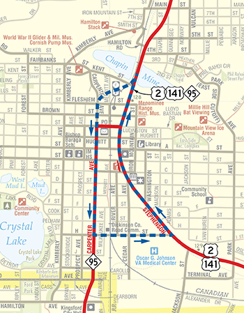 of-way, sidewalks were immediately adjacent to the highway with logging trucks literally coming within feet of pedestrians. A combination of a lack of other parallel through routes and the natural barrier of theMenominee River separating the states of Michigan and Wisconsin resulted in this heavy traffic—25% of which was through traffic just trying to get through the city—being funneled through the heart of Iron Mountain.
The first "preferred alternative" settled upon in April 1979 by MDOT, the Iron Mountain Advisory Committee (IMAC), and Breitung Twp officials was to create a downtown one-way pair configuration for US-2/US-141 and M-95 using Stephenson Ave for westbound and northbound traffic and Carpenter Ave for eastbound and southbound traffic (see map at left, or view a larger version). One-way pair configurations were a popular solution to downtown traffic problems in the 1970s. Further proposals explored using Washington St for wbd/nbd travel, but in May 1980 the Iron Mountain City Council stated changes to the traffic flow in the city were no longer desired and MDOT terminated that study.
Bypass Study Reinitiated
By March 1986, however, MDOT reinitiated the study of possible solutions to the traffic issues in Iron Mountain, as congestion and logging truck volume had only worsened. MDOT met with officials from the Dickinson Co Road Commission to discuss a bypass in October 1986. Then the Iron Mountain City Manager sent MDOT a letter in January 1988 requesting both the bypass and existing downtown one-way pair alternatives be eliminated, asking instead for existing US-2/US-141 be widened to five lanes, where possible, and a different one-way pair solution downtown, using the existing route paired with "a route west of US-2," although a single, already-existant convenient parallel route to the west of Stephenson Ave doesn't seem to exist. However, after an open house in March and a resolution from Breitung Twp officials in support of the bypass in May, the City of Iron Mountain sent MDOT a council resolution officially supporting construction of a "junction-to-junction" (from the M-95 jct north of the city to the jct of US-2 & US-141 southeast of the city) bypass.
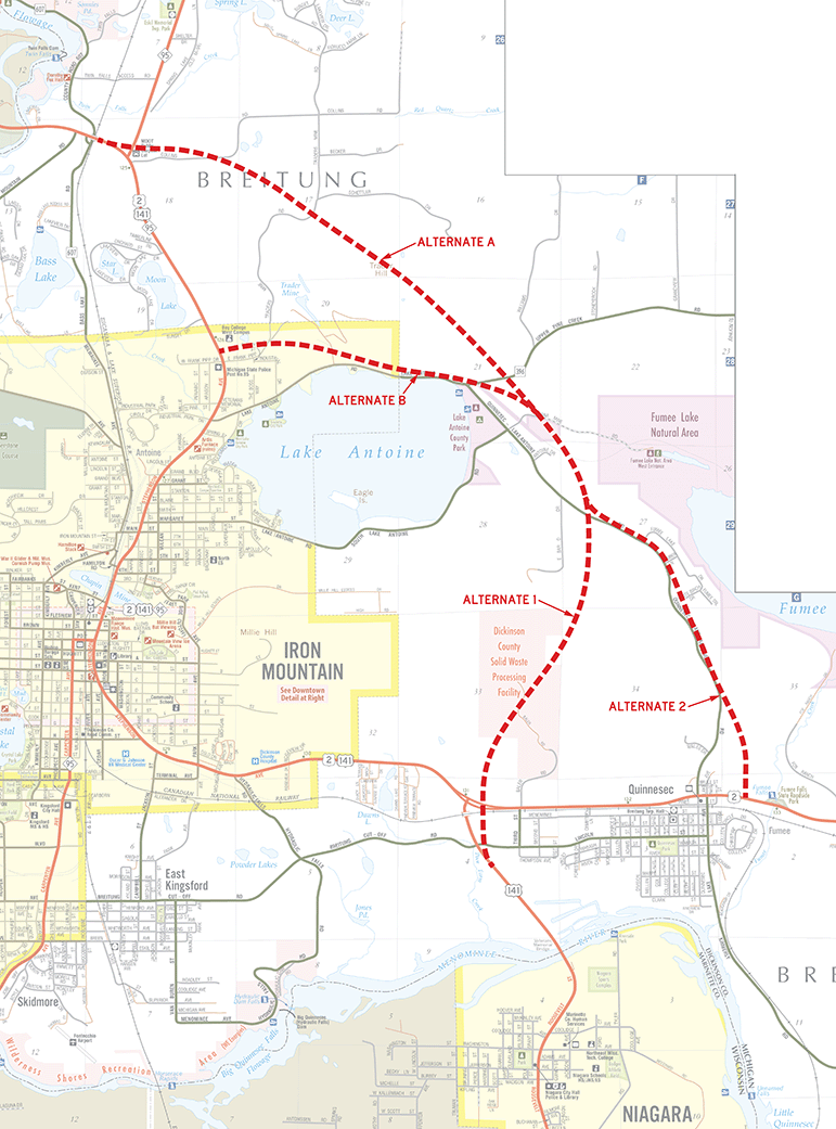 After an additional open house at Breitung Twp in May 1989, MDOT then published a Draft Environmental Impact Statement (DEIS) for a two-lane, new alignment US-2/US-141 bypass of Iron Mountain with four route alternatives (see map at right, or view a larger version), which was approved by the Federal Highway Administration (FHWA) on April 13, 1994. Following the public hearing on the DEIS, the project study team "concluded that more detailed topographic information was needed to assist in the refinement, evaluation, and selection of a preferred location for the bypass in this area of rugged terrain." Over the next two years, detailed topographic mapping of the potential bypass routes was carried out and in the spring of 1996, planning was resumed on the project using the newly-acquired data. The resulting analysis allowed MDOT to refine the potential bypass alternatives into a new set that, while closely resembling those in the DEIS, helped to mitigate some of the negative effects they could potentially cause. Three major build alternates were created which allowed for the creation of nine possible routes using varying combinations of the three alternatives. The lengths of these combinations ranged from 4.14 miles up to 6.59 miles, each with their advantages and disadvantages, similar to the original DEIS alternatives, with costs ranging from $13.2 million up to $29.7 million.
FEIS: No-Build Option Chosen
In the process of creating the Final Environmental Impact Statement (FEIS), MDOT determined a new-alignment bypass for US-2/US-141 around Iron Mountain would likely not attract enough of the through traffic—only 10% by some counts—to justify both the expense to construct the bypass as well as the negative environmental and socioeconomic effects which come with new highway construction.
Beyond the cost and low traffic siphoning issues, MDOT also noted two additional potential bypass routes had been created that may help lessen the congestion and heavy trucking impacts. First, in 1990 the City of Iron Mountain and Dickinson Co Road Commission secured a grant to make major improvements to Lake Antoine-Quinnesec Rd and, while not constructed to trunkline standards—having "restricted horizontal and vertical sight distance, narrow unpaved shoulders, and a significant amount of adjacent residential development"—does function as a "local bypass" and has drawn a portion of the truck traffic. Second, in October 1991 MDOT re-established M-69 along its 1927–1960 routing from US-2/US-41 at Hyde Park northwesterly to M-95 near Randville which, when coupled with the remainder of M-69 into Crystal Falls, also "also presents an alternate route for long distance traffic desiring to bypass Iron Mountain," according to the Department. The environmental impacts from the construction of the bypass route as well as a vocal opposition which "remained constant at about 50% of those who provided comments" throughout the study period also influenced the Department's decision. Additionally, the conditional support for the bypass project offered by the Iron Mountain City Commission in 1988 was officially rescinded by resolution in May 1994 with support instead for improvements to the existing route through the city and for implementation of a "truck bypass" route as proposed by the Dickinson Co Road Commission.
As stated in MDOT's "Five Year Road & Bridge Program, Volume II," which covered 2000–2004:
The study of roadway alternatives for the proposed US-2 Bypass of Iron Mountain was completed during 1999. The study determined that construction of a bypass was not feasible and, therefore, improvements to the existing US-2 alignment will be implemented. The Superior Region Office, in cooperation with the City of Iron Mountain, has identified a series of operational and geometric improvements with implementation to begin in 2000. Early preliminary engineering (EPE) for the widening of US-2 from Washington Street to Michigan Avenue will begin in 2001.
Present-Day
The transportation infrastructure of the Iron Mountain area looks today much like it did in the late 1970s when consideration of a bypass and other improvements first occurred, albeit with the minor updates and improvements made since 2000. The 1999 FEIS document noted the average daily traffic (ADT) on US-2/US-141 through downtown Iron Mountain was approximately 20,000 vehicles. With a bypass, it was projected the traffic volume would still grow to between 26,000 and 27,000 ADT by 2020 and without a bypass, as high as almost 30,000 ADT. While the 2020 traffic volumes were considerably impacted by the COVID-19 pandemic, by 2022 traffic through the city was topping out at 25,019 ADT. The segment of US-2/US-141 through Iron Mountain is roughly tied for the highest traffic volumes along the entire length of US-2 in Michigan, with the other segment being US-2/US-41/M-35 on the north side of Escanaba—a four lane divided highway with Michigan Lefts. The Lake Antoine-Quinnesec Rd "local bypass" carries nearly 4,200 ADT, far above other similar county roads in the reason by a factor of neary 8.5 times.
For US-2 through traffic, Lake Antoine-Quinnesec Rd is often algorithmically chosen by online/mobile mapping services over staying on US-2/US-141, with the informal bypass route being nearly a mile shorter in length and potentially three minutes shorter in drive time under the best conditions. For US-141 through traffic, though, continuing through downtown Iron Mountain takes generally the same amount of time as the Lake Antoine-Quinnesec route and is nearly two miles shorter, limiting the effectiveness of the "local bypass" option. For longer distance travel, the "M-69 alternate" for US-2 traffic is approximately five miles shorter and can sometimes shave nearly ten minute off the travel time between Escanaba and Crystal Falls in optimal conditions, although the desolate nature of the M-69 route can limit it as an option for those looking for motorist services such as fuel, food and lodging.
Additional Information