

| Back to Previous Route: I-94 |
 |
On to Next Route: M-95 |
| Western Terminus: | M-553 just southwest of Marquette Sawyer Regional Airport (formerly Sawyer International Airport and K.I. Sawyer Air Force Base), north of Gwinn in Marquette Co. |
| Southern Terminus: | US-2 immediately south of downtown Manistique (at cnr of Maple St & Lake Shore Dr) in Schoolcraft Co. |
| Length: | 87.196 miles |
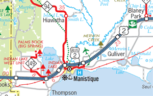
| Maps: | Route Map of M-94 |
| Notes: | M-94 between M-553 and Shingleton (eastern M-28 & M-94 jct) is an east-west highway, while the portion between Shingleton and Manistique trends north-south. However, unlike the other many "directionally-challenged" routes in Michigan, M-94 is almost completely signed as an east–west route through its entire length. Oddly, the M-94 route markers along US-2 at M-94's southern terminus in Manistique both point to "NORTH M-94," while the remainder of the signs throughout Manistique stick with "east" and "west." It is interesting in that while many other highways have their directional signs change en route, including others in the U.P., this one does not. (The reasons for that have not yet been discovered.) |
| Near its southern terminus in downtown Manistique, M-94 crosses the Manistique River via the historic Siphon Bridge, constructed in 1918 and a longtime fixture on the route of M-12 and US-2 until a new Manistique River bridge was built downstream in the early 1980s. From the US-2 Manistique River Bridge Reconstruction: Environmental Impact Statement (1979), the bridge was described as: US-2 crosses the Manistique River on a combination reinforced concrete T-beam and reinforced concrete slab structure constructed by the Manistique Pulp and Paper Company in 1918. The bridge was constructed as part of a complex flume project to provide hydropower for the paper mill industry. The roadway of the bridge is approximately three feet (.9 m) below the water level in the flume, with the railings acting as a dam to keep water off the bridge deck. Approximately 2 million cubic feet of water is normally contained in the flume, above the bridge deck. This unique design is a tourist attraction and the bridge is signed with a breif[sic] history description. The bridge is 296 feet (90.2 m) long, consisting of five spans over the flume and three spans over the unimpounded portion of the river. The structure is 60 feet (18.3 m) wide, with a pavement (clear roadway) and approach width of 42 feet (12.8 m). Pedestrian traffic is served by a 10-foot (3.05 m) wide sidewalk on each side of the bridge.
At the time of the 2004 Siphon Bridge restoration, the flume through which water powering the mill flowed was altered and its sides cut down ten feet, lowering the water level in the flume so that the bridge itself is no longer supported by the water underneath it. While the reasons for the bridge's historic notoriety—and it's listing in Ripley's Believe It or Not!—where the roadway level of the bridge was actually below the surface of the water flowing beneath it are now gone, the century-plus-old bridge remains a local landmark and is still heavily-promoted by area tourism organizations. |
|
On October 1, 1998, the entire lengths of Marquette Co Rd 460 and Co Rd 462, as well as K.I. Access Rd, Avenue A, Voodoo Ave, Avenue BB and 5th St across the former K.I. Sawyer Air Force Base (later Sawyer International Airport, now Marquette Sawyer Regional Airport), were transferred to the state to be maintained as a state trunkline. The transfer was one of several as a part of the Rationalization process. As the eastern end of Co Rd 460 intersected US-41 about a mile north of the western terminus of M-94, the M-94 designation was extended westerly over this new trunkline. Route signage was placed in late-September 1999. The specific route of this extension being:
|
|
In "State Trunkline Needs, 1960–1980," a set of maps prepared by the State Highway Dept's Office of Planning, Programming Division in 1960 showing possible additions, upgrades and improvements to the state trunkline system over the ensuing twenty years, MSHD staff recommended the following pair of major changes to the route of M-94 during that timeframe:
|
|
| History: | 1917 (Jan 3) – A 16-mile long state trunkline route is officially established in Alger Co beginning at the northern limit of Munising and continuing southerly and easterly through downtown Munising then easterly along present-day H-58 to just east of present-day H-15, then east-northeasterly roughly paralleling a logging railroad toward Cusino, terminating at the Alger/Schoolcraft Co line. The new route is given the designation T.L. 94 (Trunk Line 94), although the portion from east of Van Meer easterly to the Schoolcraft Co line has not yet been constructed. |
| 1919 (July 1) – T.L. 94 is signed in the field as M-94 as all state trunkline highways in Michigan are signed with route markers. Highway maps indicate the route may actually be signed beginning at M-25 (later redesginated M-28) south of Munising, then northerly into Munising before turning easterly along its designated route to the Van Meer area where the constructed portion ends. While the newly-signed route of M-94 may have intersected M-25 south of Munising, the officially-established route of M-94 does not intersect any other designated state trunkline highways at this point. | |
| 1925 (Oct 8) – The easternmost 14 miles of the 16 mile segment of M-94 desiganted in 1917 are turned back to county control from downtown Munising (at present-day jct M-28 & H-58) easterly to the Schoolcraft Co line. Simultaneously, a westerly extension of M-94 from the north city limit of Munising running south of present-day M-28 to just west of Christmas then westerly along the present-day M-28 corridor to a new western terminus in downtown Au Train. While not a part of the officially established route of M-94, a 0.7 mile segment of Cedar & Prospect Sts in southeastern Munising is likely signed as part of M-94 in order for it to connect to another state trunkline highway. | |
| 1927 (Aug 30) – A dedication ceremony is held at the Hiawatha Grange Hall in Hiawatha to commemorate the opening of M-94 between Manistique and Shingleton as a state highway, known locally as "the Hiawatha Road." This segment of highway, however, would not be officially established as a state trunkline route for another five months. | |
| 1928 (Jan 27) – A new 34.8-mile long trunkline highway is officially established as a state trunkline highway route in Alger and Schoolcraft Cos, beginning at M-25 (soon to be redesignated as part of an M-28 extension) in Shingleton and continuing southerly, easterly and southerly again, terminating at US-2 in Manistique. This new route is given the designation of M-94, however as this new segment is separated by the existing segment from Munising to Au Train by approximately 11 miles. Another new trunkline routing will be officially added between Shingleton and Munising in less than five months, so it's not clear how the gap is filled initially. M-94 route markers may have been temporarily added to the segment of M-25 between Shingleton and Munising, M-94 route markers may have been added to the future route to be established in May (prior to that route's official establishment), or the route of M-94 may have been discontinuous—in signage in the field at least—for those five months. | |
| 1928 (May 14) – A 13.6-mile long state trunkline route is officially established in Alger Co beginning at M-94 at the cnr of Munising Ave & Cedar St in Munising and continuing easterly via present-day H-58 for 9.2 miles to Van Meer, then southerly along present-day H-15 for 4.4 miles to the jct of M-28 & M-94 in Shingleton. The western two-thirds of this new route (Munising–Van Meer) follows a portion of highway which had been previously established as M-94 until October 1925. M-94 now begins at Au Train, continues easterly through Munising to Van Meer, then southerly through Shingleton, ending in Manistique. Construction on the Shingleton-to-Manistique segment is still underway, however. The 0.7 mile segment of what had likely been signed as part of M-94 in the southeastern part of Munising is now given a new route designation: M-178. | |
| c.1931 – A new alignment for M-94 (present-day H-58/E Munising Ave) on the east side of Munising between approximately Washington St and Connors Rd (present-day H-13) is constructed, based on right-of-way acqusition dates. | |
| 1931 (Dec 7) – M-94 is extended by 6.1 miles along a new alignment from the Scott Falls area (approximately 1½ miles east of Au Train) westerly along the present-day route of M-28 to Rock River Rd (present-day H-01) east of Shelter Bay. Construction on the route is completed in 1932. | |
| 1932 (Oct 29) – After having been bypassed by the new shoreline routing of M-94 the previous October, the 1.22-mile long former route of M-94 from the Scott Falls area westerly along Woodland Ave into Au Train is cancelled and turned back to county control. | |
| 1933 (Jan) – A huge white pine, four feet in diameter and reaching over 150 feet in height, is discovered along the proposed extension of M-94 approximately 1½ miles east of Deerton. As the tree would be situated only 8 inches from the centerline of the new highway, it is proposed to be removed unless a local business or civic organization steps forward to have it preserved as a monument to the old lumbering days in Michigan. If that occurs, the new highway would be split with traffic passing on either side of the massive tree. | |
| 1933 (July 12) – A new 8.7-mile alignment for M-94 from the west end of Munising through Christmas to the Scott Falls area (approximately 1½ miles east of Au Train) along the present-day route of M-28 is officially established as a trunkline route, while the former 7.6-mile long route between the same two points is cancelled as a state trunkline (either turned back to local control or obliterated as a public roadway). | |
| 1933 (Feb 9) – A 6.87-mile long westerly extension of M-94 in northwest Alger Co is officially established beginning at the western end of the existing highway at Rock River just east of Shelter Bay and continuing westerly to Deerton Rd approximately 1½ miles north of Deerton. While officially established as a state trunkline route, the roadway itself will not be completed for another two years. | |
| 1935 (Jan 7) – The final 15.7 mile segment of M-94 between Munising and Marquette from Deerton Rd near Deerton in northwest Alger Co westerly to US-41/M-28 at Harvey in Marquette Co is established as a state trunkline highway route. Due to funding shortfalls, this segment road highway will not be completed and officially opened to traffic for almost four years. | |
| 1935 (July) – Construction on the 6.87-mile long westerly extension of M-94 between Rock River and Deerton Rd in northwestern Alger Co, officially established as a state trunkline highway route in early 1933, is largely complete and open to traffic. Only sodding, seeding, guardrail installation and cobble gutter construction is left and will be done by mid-September. The $45,000 gravel surfacing project is financed through a grant from the federal government under the Hayden–Cartwright Act, which was enacted in 1934 to provide unemployment relief through highway-building projects. | |
| 1937 (Aug 30) – With the relocation of US-2 in Schoolcraft Co from Manistique westerly toward Thompson onto a new shoreline routing, the former route of US-2 between Manistique and M-149 north of Thompson is cancelled as a state trunkline route and turned back to local control with the exception of the approximately ½ mile portion along Deer St in Manistique from M-94/Fifth St easterly to Chippewa St—the new route for US-2 heading west out of Munising. The route of M-94 is extended from its former southern terminus at Fifth St & Deer St easterly over the former US-2 route to the cnr of Deer St & Chippewa St, extending the total length of M-94 by almost ½ mile. | |
| 1937 – Highway maps show four additional miles of M-94 added, albeit as "graded earth" highway, from Deerton Rd near Deerton westerly to the Alger/Marquette Co line. This portion of the route will be fully surfaced in two years and additional segments of the new M-94 are being constructed to take the highway west to US-41/M-28 at Harvey, south of Marquette. | |
| 1939 (July) – An additional seven miles of newly-constructed M-94 are gravelled and opened to traffic from Deerton Rd in northwestern Alger Co north of Deerton westerly into Marquette Co to one mile west of the community of Gordon (at present-day Kawbawgam Dr). Progress on this segment of highway was delayed, however, due to unusually heavy rains. The final five miles of M-94 between Gordon and US-41/M-28 at Harvey remain under construction. | |
| 1939 (Dec 6–26) – While the remainder of the route of M-94 from the community of Gordon in eastern Marquette Co westerly to US-41/M-28 at Harvey is essentially complete—completing the new Lake Superior shoreline trunkline route between Munising and Marquette—state highway officials make the decision to close the new highway in early December, rather than open it to traffic. The reason given is that the gravel surface of the highway is the same color as the soft gravel shoulders, which renders the new highway unsafe for travel. There is also concern that heavy trucks will damage the soft surface. However, officials open this segment to travel once the highway is completely frozen for the winter on Dec 26. Dedication of the new highway, originally to have ocurred during the fall, has been postponed until the spring of 1940. | |
| 1941 (July 1) – The routes of M-94 and M-28 west of Munising are swapped, a change ordered by State Highway Commissioner G. Donald Kennedy "for the benefit of through traffic on M-28, a route which extends the length of the Upper Peninsula." The length of M-28 is now six miles shorter verus the route via Skandia, Sundell, Eben, Chatham and Forest Lake, while the overall length of M-94 is also shortened by six miles. The western terminus of M-94, formerly at Harvey south of Marquette, is relocated to US-41 southeast of Skandia. At Munising, M-94 turns southerly via Cedar St, supplanting the M-178 designation to a jct with M-28 at Alger Falls south of Munising where it now turns westerly following the former route of M-28 through Chatham to US-41 near Skandia. Similarly, M-28 now continues northerly, concurrently with M-94, from Alger Falls into Munsing, where it turns westerly at Munising Ave to replace M-94 through Christmas and past Au Train and Deerton to Harvey where it continues with US-41 through Marquette, Ishpeming, Negaunee and westerly. | |
| 1949 (Nov 4) – The route of M-28/M-94 in the southeastern portion of Munising in Alger Co is realigned onto a brand-new 0.41-mile long alignment, which is officially established as a state trunkline route. Simultaneously, the former 0.6-mile long route via Cedar St from Onota St to Prospect St and Prospect St from Cedar St to the new M-28/M-94 alignment is turned back to municipal control. The realigned M-28/M-94 also opens to traffic on or soon after this date as well. | |
| 1955 (Aug 3) – A new, more-direct alignment for M-94 is officially established in central Alger Co southwest of Munising which eliminates several sharper curves in the route. The new alignment begins at the Lake Superior & Ishpeming RR overpass 2.9 miles west of M-28 and continues 3.9 miles southwesterly to just west of 16 Mile Lake Rd and shortens the route of M-94 by ½ mile. The former 4.4-mile alignment is turned back to county control. Construction on the new alignment is scheduled to be completed by Nov 15. | |
1957 (June 24) – Two realignments to the route of M-94 are officially established as state trunkline highway routes today:
|
|
| 1957 (July 30–Aug 19) – Yet another new, more-direct alignment for M-94 is completed and opened to traffic in western Alger Co between Chatham and Eben Junction on July 30, eliminating two 90° turns in the route. The new alignment begins approximately ¾ mile west of downtown Chatham and continues 1.4 miles northwesterly and westerly to Eben-Trenary Rd (present-day H-01) and shortens the route of M-94 by 0.3 mile. The realignment is part of an 8.6 mile long reconstruction project from Chatham westerly to the Alger/Marquette Co line, costing $520,000. On Aug 19, the new alignment is officially established as part of the M-94 route, while the former 1.7-mile alignment along Old 94 and Eben-Trenary Rd is turned back to county control. | |
| 1959 (May 18) – A 10.2-mile long realignment and upgrade to M-94 through western Schoolcraft Co is officially established and the 10.9-mile former route is cancelled with segments turned back to county control, obliterated or subsumed under the relocated and reconstructed highway. The realignment spans from a point 1¼ miles northwest of Co Rd 449 southeast of Steuben northerly to approximately ¼ mile south of Clear Lake Rd near Lily and Boot Lakes. Most of the segments of former M-94 not obliterated or buried under the new alignment are turned back to county control and are renamed Co Rd 452, except the segment spanning the Middle Br of Stutts Cr, which has its bridge crossing the creek removed and is named Old M-94 or Old State Rd. (On July 30, the Schoolcraft Co Road Commission authorizes abandonment of much of Old M-94/Old State Rd from its southern end at M-94, across the timber bridge spanning Middle Br of Stutts Cr and up "Ferguson Hill," which experiences frequent wash-outs. The timber bridge is removed as part of the abandonment.) | |
| 1959 (Dec 1) – Following an upgrading and resurfacing project along the whole segment, the 13.6-mile long M-94 "loop" north of M-28 between Munising and Shingleton is, once again, cancelled as a state trunkline highway. The former route of M-94 from Munising easterly to Van Meer (present-day H-58) and from there southerly to Shingleton (present-day H-15) is transferred to county control. From Shingleton, M-94 now runs concurrently with M-28 to the western jct of M-28 & M-94 south of Munising. The formerly concurrent M-28/M-94 segment from that point northerly into Munsing becomes just M-28. These changes shorten the length of M-94 by 5.8 miles and bring the route to its current configuration east of US-41. | |
1960 (Oct 14) – Three separate realignments to the route of M-94 in northwestern and central Schoolcraft Co are officially established as state trunkline routes and likely open to traffic around this same time as well. The three segments are:
|
|
| 1960 (Nov 4) – The route of M-28/M-94 is reconstructed and partially realigned from the Wetmore area in central Alger Co easterly to jct M-28 & M-94 in Shingleton. The entire 8.31-mile segment is officially established on this date, while the 8.43-mile old alignment is cancelled and is turned back to local control, obliterated, or subsumed under the reconstructed highway. Beginning at Alger Heights Rd on the western edge of Wetmore, a new, more direct 1.1-mile long M-28/M-94 bypass of the community removes through traffic from the business district of Wetmore and merges back with the existing alignment 0.4 mile east of H-13/FH-13/Connors Rd. The former route along Prospect St through Wetmore from M-28/M-94 west of the community easterly to H-13/FH-13/Connors Rd is turned back to county control, while the portion east of H-13/FH-13 is obliterated as a public roadway. Between Wetmore and Shingleton, M-28/M-94 is upgraded and slightly shifted to the north. From approximately 1½ miles west of Shingleton, M-28/M-94 is shifted onto a new, more notherly alignment to Pine St, one block west of the M-28 & M-94 jct in downtown Shingleton and the former alignment is obliterated as a public roadway. | |
| 1961 (Jan 6) – The five-mile segment of M-94 beginning at M-67 south of Chatham and continuing easterly through Forest Lake is reconstructed (and a wider right-of-way is acquired), which also includes the last stretch of unpaved M-94—one of the last unpaved state highways in all of Michigan to be completely hard-surfaced. The reconstruction also includes a ½-mile realignment east of Slapneck Rd west of Forest Lake, replacing a sharper reverse-curve with a more gentle alignment. The former route is obliterated as a public roadway. | |
| 1976 (Aug 6) – As the Dept of State Highways & Transportation continues planning for a new US-2 bridge spanning the Manistique River south of the existing US-2 "Siphon Bridge" in Manistique, the newly-appointed Manistique City Manager objects to departmental plans to turn back the eastern two-thirds of the existing route of US-2 through the city to municipal control (and routing M-94 along the Chippewa Ave leg of the route), which would place maintenance responsibility of both the former US-2 route and the Siphon Bridge in the city's hands. The MDSH&T agrees to flip their proposed jurisdictional transfer so that Chippewa Ave from Deer St southerly to relocated US-2 would be turned back to the city while the remainder of existing US-2 and the Siphon Bridge would remain under state control as an extension of M-94. | |
| 1984 (Nov 1) – A new US-2 Manistique River bridge is completed and opened to traffic at Manistique, bypassing the historic Siphon Bridge and shortening the route of US-2 by 1.4 miles. The portion of US-2 via Chippewa Ave on the west side of Manistique from relocated US-2 northerly to Deer St temporarily becomes an unsigned state route while the remainder of the former US-2 routing through the city is designated as an extension of M-94. | |
1998 (Oct 1)
|
|
| 2002 – MDOT recognizes the route of M-94 through the former K.I. Sawyer AFB—now Sawyer International Airport since September 1999 (present-day Marquette Sawyer Regional Airport)—requires traffic to make several 90° turns and re-engineers the highway to "cut-off" each of the turns, resulting in a smoothly-flowing route across the old base. | |
| 2009 – As part of a 9-mile resurfacing project along M-94 north of Manistique, the alignment of the highway is straightened where the Manistique & Lake Superior RR formerly crossed the roadway. Decades earlier, the State Highway Dept realigned M-94 to cross the railroad at a less-shallow angle for improved safety and sight lines. For the forty years since the tracks were removed in 1968, the highway still curved at what became the Haywire Trail snowmobile route. As the need for the curved alignment no longer exists, MDOT restores the formerly due north-south alignment where it now crosses the snowmobile trail, which itself is realigned to cross the highway at a 90º angle. The old roadway is obliterated and returned to nature. | |
| Controlled Access: | No portion of M-94 is freeway or expressway. |
| NHS: | Two segments—both due to concurrencies with other routes—of M-94 are on the National Highway System (NHS):
|
| Circle Tour: | |
| Memorial Highway: | At present, no portion of M-94 has been designated as part of a Memorial Highway. |
| Photographs: | |
| Weblinks: |
|
 Had the
 | Back to I-94 | Route Listings Home | On to M-95 |