

| Back to Previous Route: Former M-148 |
 |
On to Next Route: M-150 |
| Southern Terminus: | US-2 at Thompson |
| Northern Terminus: | Entrance of Palms Book State Park, 10.6 miles north of Thompson |
| Length: | 10.606 miles |
| Maps: | Route Map of M-149 |
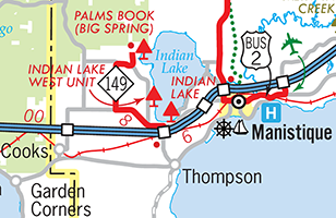
| Notes: | The primary purpose of M-149 is to connect the Indian Lake State Park units and Palms Book State Park with US-2 at Thompson. |
| M-149 is a rather lightly-used state trunkline spur route in southwestern Schoolcraft Co, not surprising as the roadway which continues northerly from the northern terminus of M-149, Sawmill Rd, is a minor, unpaved roadway which peters out and becomes difficult to traverse approximately 2¼ miles north of Palms Book State Park. While one of the primary purposes for the existence of this state highway route is to provided access to Palms Book State Park, it follows a bit of a roundabout path to get there. While motorists can save 1.9 miles when driving to the state park at the end of the route from US-2 at Thompson by using Co Rd 455, which runs closer to the west shore of Indian Lake and begins and ends at M-149, Co Rd 455 was not constructed until 1960, thirty years after M-149 was first established as a trunkline. (Co Rd 455 was not paved in its entirety until the 1980s at the earliest.) There has been no known push for the state and Schoolcraft Co to swap jurisdiction of M-149 and Co Rd 455, even though that would result in a shorter route for M-149 and the state highway would now directly serve the Westshore Unit of Indian Lake State Park. (The greater number of residential/vacation homes along Co Rd 455 when compared with M-149 may have something to do with this.) | |
"On June 8, 1849, Algernon Merryweather came across the spring while conducting the original survey for the General Land Office of the U.S. Government, noting 'West end of arm of Lake is a spring 450 links in diameter. Water 4½ fathoms deep from which proceeds a large brook.' Early photographs document tourism at the site in the late 1890s, at which time Manistique was a bustling mill town. Initially, visitors would cross Indian Lake and then hike to the Kitch-iti-kipi. Later, a narrow-gauge railroad was installed to transport visitors from Thompson to the Kitch-iti-kipi. Originally, people built their own rafts to go out onto the water. Through the years, the raft evolved to include a 'viewing well' and various methods of moving it around, including being pulled by a rowing boat." "John I. Bellaire, a local businessman, found the spring completely full of lumber and workers’ trash and immediately wanted to clean it up and restore its natural beauty. He prompted a deal with the Palms Book Land Company to sell 90 acres of the land around the spring to the state for $10 to preserve the area as a state park. The purchase was completed in 1928. The deed stipulated that the land 'to be forever used as a public park, bearing the name Palms Book State Park.' John I. Bellaire lived in Manistique and would advertise the spring there. He sold water and sand from the spring at his five-and-dime store claiming they had magical powers. Bellaire was instrumental in the construction of the present-day highway M-149 to provide easier access to the park." |
|
 In "State Trunkline Needs, 1960–1980," a set of maps prepared by the State Highway Dept's Office of Planning, Programming Division in 1960 showing possible additions, upgrades and improvements to the state trunkline system over the ensuing twenty years, MSHD staff recommended the cancellation of the portion of M-149 south of the proposed US-2 freeway which was to link Escanaba with I-75 at Saint Ignace. (The former route of US-2 was to also be turned back to local control.) As this 130-mile long US-2 freeway was never constructed, this modification to the route of M-149 never came to fruition. In "State Trunkline Needs, 1960–1980," a set of maps prepared by the State Highway Dept's Office of Planning, Programming Division in 1960 showing possible additions, upgrades and improvements to the state trunkline system over the ensuing twenty years, MSHD staff recommended the cancellation of the portion of M-149 south of the proposed US-2 freeway which was to link Escanaba with I-75 at Saint Ignace. (The former route of US-2 was to also be turned back to local control.) As this 130-mile long US-2 freeway was never constructed, this modification to the route of M-149 never came to fruition. |
|
| History: | 1930 (Dec 2) – A new 3.7-mile long state trunkline route, designated M-149, is established along a roadway yet-to-be-constructed from US-2 (present-day Co Rd 442) west of Indian Lake in Schoolcraft Co, running due northerly ½ mile west of present-day Co Rd 455 roughly along the alignment, in part, of a former logging railroad grade. As the officially-established route doesn't exist as an actual roadway, M-149 is "marked-and-maintained" along an existing county road approximately 1½ miles to the west, running essentially along the present-day alignment of M-149. The new M-149 begins at US-2, runs due northerly for nearly 3 full miles, then bends east-southeasterly and winds around for approximately a mile before turning northerly again for approximatley ¾ mile to the new Palms Book State Park, established the year prior. |
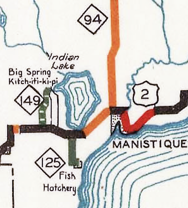 1931 (June 19, Aug 31) – On June 19, the State Administrative Board approves a new short spur highway from US-2 west of Manistique to serve the new Thompson State Fish Hatchery as part of 30 additional miles of roadway approved to be added to the trunkline sytem. (At this time, US-2 runs along present-day Co Rd 442 west of Manistique via Cooks instead of the present-day shoreline routing—see map at right.) Then 10½ weeks later on August 31, a new 1.5-mile long spur route, designated M-125, is established as a state trunkline highway five miles west of Manistique, beginning at US-2 at the southern tip of Indian Lake and continuing southerly to the Thompson State Fish Hatchery just north of the hamlet of Thompson. 1931 (June 19, Aug 31) – On June 19, the State Administrative Board approves a new short spur highway from US-2 west of Manistique to serve the new Thompson State Fish Hatchery as part of 30 additional miles of roadway approved to be added to the trunkline sytem. (At this time, US-2 runs along present-day Co Rd 442 west of Manistique via Cooks instead of the present-day shoreline routing—see map at right.) Then 10½ weeks later on August 31, a new 1.5-mile long spur route, designated M-125, is established as a state trunkline highway five miles west of Manistique, beginning at US-2 at the southern tip of Indian Lake and continuing southerly to the Thompson State Fish Hatchery just north of the hamlet of Thompson. |
|
| 1936 (early July) – A new relocation for US-2 from southwest of Cooks easterly through Thompson and into Manistique is completed and opened to traffic, running along the Lake Michigan shore between Thompson and Manistique, although the former route (along present-day Co Rd 442) is not yet cancelled as a state trunkline route. Until now, M-149 existed solely as a spur route leading northerly from the former US-2 to Palms Book State Park. With the completion of the relocation for US-2, the existing 1.5 mile route of M-125 from the former US-2 southerly to the Thompson State Fish Hatchery is redesignated as part of M-149—with the segment of the former US-2 between the two M-149 junctions becoming signed as part of the new, extended M-149 route—while the 1.35-mile long county roadway from the southern end of M-125 at the fish hatchery southerly to a jct with relocated US-2 in "downtown" Thompson is now "marked-and-maintained" as part of M-149, although a formal establishment for that portion of the route has not yet happened. This marks the end to the first iteration of M-125. | |
| 1937 (Aug 30) – On the same day as much of the former route of US-2 between Cooks and Manistique along present-day Co Rd 442 is turned back to local control, with the exception of the portion now signed as part of M-149, two major official changes come to the route of M-149 which actually result in no physical changes to the signed highway itself. First, the 1.35-mile long county roadway from the southern end of the former M-125 at the Thompson State Fish Hatchery southerly to relocated US-2 in "downtown" Thompson is officially established as a state trunkline highway and transferred from county to state jurisdiction. (It has been "marked-and-maintained" by the state as part of M-149 for over a year at this point.) Second, the originally-established 3.7-mile long route for M-149 from the former US-2 route (present-day M-149) northerly to Palms Book State Park is officially cancelled and what was intended to be a temporarily "marked-and-maintained" 4.7-mile long route is now officially established as the permanent route for M-149. With a few minor exceptions M-149 now takes on its present-day form. | |
| 1960 (Oct 15) – The two portions of M-149 which had not previously been part of the former route of US-2 in the 1930s leading northerly and southerly away from Co Rd 442 are fully hard-surfaced during the 1960 constructions season, with project completion by October 15. M-149 is now paved throughout. | |
| c.1975–76 – In the mid-1970s (prior to 1977), the formerly sharp, horsehoe-like curve at the intersection of M-149 & Co Rd 453/Miller Rd is reconstructed into a sweeping 90° curve and the remainder of the east-west segment of M-149 from that point easterly to Co Rd 455 is rebuilt and several sharper turns are straightened, improving safety along the route. The old route of M-149, where it is not subsumed under the newly rebuilt highway, is obliterated as a public roadway. | |
| Controlled Access: | No portion of M-149 exists as freeway or expressway. |
| NHS: | No portion of M-149 is on the National Highway System (NHS). |
| Photographs: | |
| Weblinks: |
|
| Back to Former M-148 | Route Listings Home | On to M-150 |