| M-126 is a former state trunkline route existing from 1934 until July 1, 1940. |
| Western Terminus*: |
US-31A/Peck St at cnr Airline Hwy in downtown Muskegon Heights |
| Eastern Terminus*: |
US-16/Cleveland St at cnr 112th Ave (present-day B-31) |
| Final Length*: |
13.6 miles |
| Maps: |
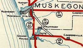
Route Map of Former M-126 (1939) |
| Notes: |
*The termini and final length for M-126 reflect the beginning and ending of the route and its length as of the time of its decommissioning in July 1940. |
| |
M-126 was a relatively short-lived state highway designation in the Greater Muskegon/Grand Haven area, existing from 1934–1940 as a cut-off route from US-16 at Nunica and the Muskegon area. Prior to 1940, US-16 proceeded directly west from Nunica in northern Ottawa Co through Spring Lake to a terminus at US-31 in Ferrysburg, across the Grand River from Grand Haven. Until the summer of 1934, the Wisconsin & Michigan Steamship Co operated a line connecting Grand Haven and Milwaukee, Wisconsin which was labeled on highway maps as "Continuation of U.S. Highway 16." In 1933, the Pere Marquette Lines, a subsidary of the Pere Marqutte Railroad (later part of the Chespeake & Ohio, then Chessie System, now CSX Transportation) began sailing from Muskegon Harbor to Milwaukee. By the next year, the Pere Marquette Lines were joined by several other steamship companies, including the Wisconsin & Michigan as well, in running ferries between Muskegon and Milwaukee, quickly supplanting Grand Haven as a leading steamship port for this portion of West Michigan. When the Wisconsin & Michigan Steamship Co ceased running boats from Grand Haven, this meant the "continuation" of US-16 across Lake Michigan was technically severed. This, the State Highway Department eventually decided to redirect US-16 from the Grand Haven area to running northwesterly from Nunica and into Muskegon via M-126, in part to resort the "continuation of US-16" via the steamship lines across Lake Michigan to Milwaukee. |
| |
M-126 is also a very interesting highway, historically, in that it began as a transportation artery in 1870—64 years before the first automobiles ever traversed it. As detailed in the "History" section below, M-126 was constructed, for the most part, atop the abandoned roadbed of the Grand Rapids, Grand Haven & Muskegon (GRGH&M) Railway, an electric interurban line serving to connect its namesake cities. The GRGH&M, itself, actually utilized a much earlier abandoned steam railroad line between Nunica and Fruitport, adding additional layers of transportation heritage into the route. Once the interurban era had concluded in the late-1920s, the State Highway Dept showed interest in acquiring the former interurban right-of-way between Nunica and Muskegon Heights, although the shift in steamship operations had not yet occured (see above). It took six years until the highway itself was completed, but portions of what are known as Apple Ave (Nunica–Fruitport) and Airline Hwy (Fruitport–Muskegon Heights) run atop the old interurban roadbed, for the most part. |
| |
After M-126 was decommissioned as a state highway route in 1940 when it was replaced by US-16 between Nunica and Muskegon Heights, there has been no other state highway in Michigan to bear that route designation. |
| History: |
The eventual route of M-126 had a long history as a transportation conduit, although not as a highway! This history section also details some of the early history of the route prior to its conversion as a roadway for vehicular use in the 1930s. |
| |
1870 – The Chicago and Michigan Lake Shore Railroad (C&MLS) constructs a railroad linking the Detroit & Milwaukee Railroad at Nunica in northern Ottawa Co to the North Yard on the east end of Muskegon Lake just north of downtown Muskegon. (In 1858, the Detroit & Milwaukee Railway [later the Detroit, Grand Haven & Milwaukee and then the Grand Trunk Western Railway] constructed the east-west line from Grand Rapids through Coopersville and Nunica and into Spring Lake.) The C&MLS line runs northwesterly from Nunica into Fruitport, mostly along the route of present-day Apple Ave. From Fruitport, the C&MLS line runs directly to the northwest into Muksegon. A year layer in 1871, the C&MLS constructs a railroad line linking Nunica directly with Holland, completing the route from Holland through to Muskegon. |
| |
1881 (July) – The Chicago and Michigan Lake Shore Railroad is merged with the Chicago & West Michigan Railroad (to form the Chicago & West Michigan Railway) which already had a line running directly between Holland and Muskegon via Grand Haven, while the 1870–71 C&MLS line via Nunica is more of an inland route running through smaller communities—a longer line with fewer potential customers. As such, the C&WM abandons its line from Holland through Nunica and as far north as Fruitport, leaving the Fruitport–North Yard section in service. Specifically related to the future M-126, the C&MLS line between Nunica and Fruitport has its rails removed, but the roadbed in the right-of-way remains in tact for the next 19 years. |
| |
1900 – After sitting idle for nearly two decades, the former Chicago and Michigan Lake Shore Railroad roadbed from Nunica through Fruitport to Picand's Junction is purchased by the Grand Rapids, Grand Haven & Muskegon Railway (GRGH&M), an electrified interurban line connecting downtown Grand Rapids with Berlin (now Marne), Coopersville, Nunica, Fruitport and Muskegon Heights with downtown Muskegon as well as a branch route from just south of Fruitport to Spring Lake and Grand Haven. |
| |
1902 (Feb 8) – After almost two years of construction, the Grand Rapids, Grand Haven & Muskegon Railway (GRGH&M) electrified interurban line is completed and starts operations between Grand Rapids and Muskegon as well as the branch from Grand Haven Jct just south of Fruitport into Spring Lake (later, into and through downtown Grand Haven to the Lake Michigan shoreline). From the Fruitport area, the GRGH&M interurban line bends to the northwest running directly into Muskegon Heights, parallelling the Pere Marquette (later C&O, now CSXT) from the east end of Mona Lake into downtown Muskegon Heights. This segment of the Interurban line is known by locals as the "airline" for its direct route between Fruitport and Muskegon Heights. |
| |
1928 (Apr 9) – Due to the proliferation of automobiles, trucks and paved highways, the fortunes of the Interuban systems across the state begin to wane in the early 1920s, with nearly every interurban statewide in receivership by 1925. Although the Grand Rapids, Grand Haven & Muskegon Railway was able to limp along slightly longer, it, too, was placed into receivership in 1926 and was formally abandoned in early April 1928, with the last regular service running on April 7. The court-appointed received was then instructed to sell off as many of the lines assets as possible to recoup money owed by the line to creditors. |
| |
1928 (Apr 12) – After the Grand Rapids, Grand Haven & Muskegon Railway interurban line had made its last regular trip prior to shutting down due to being placed into receivership, one last two-car trip is made along the line with Governor Fred W. Green, State Highway Commissioner Frank F. Rogers, State Senator Vincent A. Martin and various members from the Ottawa Co Road Commission. The purpose of the trip was to inspect portions of the line that might re-used for a "better, shorter, safer highway" to replace segments of nearby M-16 (which would be signed as part of US-16 the next month). At this point, M-16 (becoming US-16) runs northwesterly from the Grand Rapids area through Berlin (present-day Marne) and Coopersville, then due westerly past Nunica and into Spring Lake and a terminus at M-11 (becoming US-31) in Ferrysburg. |
| |
1928 (Oct 25) – The final sale to dispose of the assets of the now-defunct Grand Rapids, Grand Haven & Muskegon Railway is held and significant portions of the old inteurban's right-of-way—or at least those sections not subject to a reversionary clause to the original, abutting landowners—are purchased by either the Ottawa and Musekgon Co Road Commissions or the State Highway Dept (depending on the news source) for future use as a highway. A total of $8,000 is paid for the righf-of-way and abandoned railbed that is purchased. |
| |
 1929 (Dec 2) – A 12.7-mile long trunkline route is officially established between US-16 at Nunica in northern Ottawa Co northwesterly into Muskegon Co, through Fruitport and on into Musekgon Heights, utilizing the alignment of the recently-abandoned Grand Rapids, Grand Haven & Muskegon Railway, an electric interurban line linking Grand Rapids and Muskegon, with a spur into Grand Haven. At this time, no physical roadway runs along the route and only the old interurban right-of-way, sans tracks, exists. Initially, no work is done to convert the route into a driveable highway, but the future highway route is assigned the M-123 route designation. (See map excerpt—from a 1929 State Highway Department map.) 1929 (Dec 2) – A 12.7-mile long trunkline route is officially established between US-16 at Nunica in northern Ottawa Co northwesterly into Muskegon Co, through Fruitport and on into Musekgon Heights, utilizing the alignment of the recently-abandoned Grand Rapids, Grand Haven & Muskegon Railway, an electric interurban line linking Grand Rapids and Muskegon, with a spur into Grand Haven. At this time, no physical roadway runs along the route and only the old interurban right-of-way, sans tracks, exists. Initially, no work is done to convert the route into a driveable highway, but the future highway route is assigned the M-123 route designation. (See map excerpt—from a 1929 State Highway Department map.) |
| |
1930 (June 30)  – The 1.5-mile stretch of Getty St from Airline Hwy (established as a new state trunkline route M-123 seven months prior) northerly to Sherman Blvd east of downtown Muskegon Heights (southeast of Muskegon) is established as a state trunkline route—the first step in creating a "Muskegon East Belt" to route through traffic out of downtown Muskegon—although no roadway exists between Norton Ave and Broadway Ave and the remainder of the segment still needs to be rebuilt to state trunkline standards. – The 1.5-mile stretch of Getty St from Airline Hwy (established as a new state trunkline route M-123 seven months prior) northerly to Sherman Blvd east of downtown Muskegon Heights (southeast of Muskegon) is established as a state trunkline route—the first step in creating a "Muskegon East Belt" to route through traffic out of downtown Muskegon—although no roadway exists between Norton Ave and Broadway Ave and the remainder of the segment still needs to be rebuilt to state trunkline standards. |
| |
1931 (Mar 5) – The portion of the old Grand Rapids, Grand Haven & Muskegon right-of-way which had been purchased by the Muskegon Co Road Commission in that county is conveyed to the State Highway Dept as preparations continue to convert the old interurban line to a new state highwa yroute. |
| |
1931–33 – Since many of parcels of land used for the former Grand Rapids, Grand Haven & Muskegon right-of-way had reversionary clauses—which stated the land under the interurban's right-of-way would revert back to the original underlying or abutting landowner if it was to no longer be used for railroad purposes—the State Highway Dept receives grants of the former right-of-way from individual landowners where it had reverted. The State Highway Dept would only agree to use the former interurban line as the path for a shorter route into Muskegon from the southeast if the landowners with reversionary clauses in their deeds to the interurban would make grants of the right-of-way to the State instead of forcing the Department to purchase the parcels |
| |
1931 (Sept 18) – Local roadway officials announce the new "airline" route for M-123 entering Muskegon Heights from the southeast will, indeed, run parallel to both the Pere Marquette (later C&O, now CSXT) line and the existing route of US-31 as it enters the Muskegon area, immediately south of the railroad line. The reason for constructing a parallel 40-foot wide roadway when another 40-foot wide state trunkline highway exists just south of the new one across the railroad tracks, is that the only other option for this new highway would be to construct a grade separation at the Getty St crossing, which would have been up to twice the cost of simply building a new, parallel highway along the former interurban right-of-way just north of the Pere Marquette tracks. The Department chooses to go with the most cost-effective option. |
| |
1931 (Late) – By the end of the 1931 construction season, the "airline" route from downtown Muskegon Heights southeastery to the northern limit of Fruitport is fully graded and all drainage structures have been placed, but the highway itself is not complete nor is it opened to traffic. |
| |
1932 (Oct 29)– Two developments in the route of proposed M-123:
- The remainder of the new "Muskegon East Belt" bypassing downtown Muskegon is established as a state trunkline route, consiting of the 3.5 miles of Getty St from Sherman Blvd northery to Marquette Ave and westerly along Marquette Ave to US-31/Ottawa St northeast of downtown. The new Getty–Marquette trunkline route is assigned the M-123 designation, meaning the future highway designated M-123 now begins at US-16 at Nunica and continues northwesterly through Fruitport via Airline Hwy into Norton Twp where it turns northerly along Getty St and westerly via Marquette Ave to a terminus at US-31.
- The 5.2-mile portion of the route for M-123 between Nunica and Fruitport established in early December 1929 actually sat to the north of the Grand Rapids, Grand Haven & Muskegon Railway right-of-way that was earmarked for the future highway routing, largely paralleling the former interurban route. Whether this 1929 establishment was just an approximate routing or a cartographic error, the 5.2 miles is cancelled and a new establishment for M-123 is officially made between Nunica and Fruitport along the abandoned GRGH&M Ry roadbed instead, totalling 5.4 miles between those communities.
|
| |
 1933 (Fall) 1933 (Fall)  – By Fall 1933, the established (but not-yet-constructed) trunkline route from Nunica through Fruitport into Muskegon Heights is redesignated as M-126. In the end, the M-123 designation along this route is only used during the planning process and never actually signed along the route. – By Fall 1933, the established (but not-yet-constructed) trunkline route from Nunica through Fruitport into Muskegon Heights is redesignated as M-126. In the end, the M-123 designation along this route is only used during the planning process and never actually signed along the route. |
| |
1934 (July 11) – The vast majority of M-126 is paved and opened to traffic, specifically from US-16 on the south side of Nunica in northern Ottawa Co notherly along 112th Ave for 0.375 miles, turning westerly along South St for approximately 1,000 feet to the former Grand Rapids, Grand Haven & Muskegon Railway right-of-way, then northwesterly along the former interurban line to Grand Haven Jct just southeast of Hickory St where the new M-126 utilizes a sweeping curve to the southwest of the former interurban alignment into Fruitport. The newly-opened M-126 travels through Fruitport via Third Ave, then at the north village limit, picks back up on the former interurban roadbed to follow the "airline" route toward Muskegon to a temporary terminus at US-31A/Getty St in Norton Twp (present-day Norton Shores) southeast of Muskegon Heights. (The segment of the "airline route" from US-31A/Getty St and US-31/Peck St in Muskegon Heights remains in its graded state without any surfacing and not officially open to traffic for the time being.) A ribbon-cutting celebration, community picnic and fish fry is held in Fruitport on July 11 which includes 100 vehicles coming from Grand Rapids, Marne, Coopersville, Nunica, Muskegon and Muskegon Heights as well as the Blossom Queen of Musekgon and Miss Grand Rapids along with Governor William A. Comstock and State Highway Commissioner Murray D. VanWagoner, who both spoke at the ceremony. |
| |
1938 (Jul 1) – Even before there is any significant agitation for such a change by Muskegon area civic leaders, it becomes clear the State Highway Dept is likely planning to redesignate the entirety of M-126 as a realignment for US-16, running northwesterly from Nunica throuygh Fruitport and into Muskegon. The "Biennial Report Map" issued by the State Highway Dept as part of its 1936–38 Biennial Report to the Governor and stating "This map shows the status by surface types of the State Trunk Line System as of July 1, 1938" depicts US-16 as having been rerouted to supplant M-126 in its entirety from Nunica through Fruitport and into Muskegon. Interestingly, the same map shows the existing US-16 route from Nunica due westerly through Spring Lake to US-31 at Ferrysburg as having the M-126 designation transferred to it—essentially flip-flopping the two route designations. No route signage changes take place, official highway maps issued to the public do not show any such change, and there are no reports in the media annoucing such a change, so it can be assumed this is the Department "jumping the gun," cartographically, on a route modification that may be coming in the future. |
| |
1938 (Fall) – A 1.387-mile long paving project worth $42,736 completes the surfacing on Airline Hwy from US-31A/Getty St to US-31/Peck St in Muskegon Heights. M-126 is finally paved and completed and opened to traffic all the way to its final western terminus and its full length as a route. |
| |
1940 (Apr 9) – Local civic leaders from the Muskegon area meet with State Highway Commissioner Murray D. VanWagoner to advance several major highway projects in the Greater Muskegon area. Among them is the request to redesignate M-126 from Nunica through Fruitport to Muskegon Heights as US-16A (US-16 Alternate). Redesignating M-126 as an "Alternate" to US-16 would not work since US-16 currently terminates at US-31 in Ferrysburg, 6½ miles south of the western end of M-126, meaning M-126 would not be an alternate routing for US-16, but rather a spur. VanWagoner and the State Highway Dept had already been considering the opposite scenario: replacing M-126 with US-16 and either giving the existing US-16 between Nunica and Ferrysburg a different route designation or possibly making that route US-16A and then continuing US-16A concurrently with US-31 from Ferrysburg back to the relocated US-16 southeast of Muskegon. |
| |
1940 (May 31) – Michigan State Highway Commissioner Murray D. Van Wagoner petitons the American Association of State Highway Officials (AASHO, today's AASHTO) to approve rerouting US-16 from its Nunica-to-Grand Haven alignment to take over the route of M-126 (the "Airline Highway") from Nuncia through Fruitport to Muskegon. The M-104 designation is approved as the replacement for the portion of exisitng US-16 between Nunica and US-31 at Ferrysburg. |
| |
1940 (July 1) – Muskegon and Ottawa Co Road Commission crews, acting on instruction from the State Highway Dept, remove the M-126 route markers along the entire length of the highway, replacing them with US-16 markers. (US-16 continues into downtown Muskegon from the former terminus of M-126 in Muskegon Heights, terminating on the Mart Dock and a connection with the steamships which sail across Lake Michigan and connect with US-16 in Milwaukee, Wisconsin.) The US-16 route makers on the former route between Nunica and Ferrysburg via Spring Lake are replaced with M-104 signs at the same time. This brings the existence of M-126 to a close while ushering in the debut of M-104. |
| |
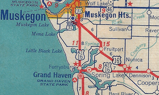 c.1940–1942 – While after the decommissioning of M-126, yet related in a way, the State Highway Dept commissions a new US-16A or ALT US-16 ("Alternate US-16") routing in the Greater Grand Haven/Ferrysburg/Spring Lake area which, in part, follows the former route of US-16 into the area from the Nunica area. As officially commissioned, US-16A begins at jct US-16 & M-104 at Nunica and runs westerly along M-104 (formerly US-16) through Spring Lake to Ferrysburg, then turns northerly concurrently with US-31 into Muskegon Co, terminating at the jct of US-16 & US-31 southeast of Muskegon. It is unclear if US-16A (or ALT US-16) is ever posted in the field, however, as the designation is never included on any official state highway map and very little is known about the designation. This route designation has only been found on a few internal State Highway Dept maps and only one commercial road map has been found with the route labeled, to date (see map). The reason for the Alternate route may have been to placate Grand Haven/Ferrysburg/Spring Lake-area civic leaders after the loss of the US-16 mainline route. If the route was actually signed in the field—and it may never have been, due to wartime labor and materials shortages—it was decommissioned within a year or two. c.1940–1942 – While after the decommissioning of M-126, yet related in a way, the State Highway Dept commissions a new US-16A or ALT US-16 ("Alternate US-16") routing in the Greater Grand Haven/Ferrysburg/Spring Lake area which, in part, follows the former route of US-16 into the area from the Nunica area. As officially commissioned, US-16A begins at jct US-16 & M-104 at Nunica and runs westerly along M-104 (formerly US-16) through Spring Lake to Ferrysburg, then turns northerly concurrently with US-31 into Muskegon Co, terminating at the jct of US-16 & US-31 southeast of Muskegon. It is unclear if US-16A (or ALT US-16) is ever posted in the field, however, as the designation is never included on any official state highway map and very little is known about the designation. This route designation has only been found on a few internal State Highway Dept maps and only one commercial road map has been found with the route labeled, to date (see map). The reason for the Alternate route may have been to placate Grand Haven/Ferrysburg/Spring Lake-area civic leaders after the loss of the US-16 mainline route. If the route was actually signed in the field—and it may never have been, due to wartime labor and materials shortages—it was decommissioned within a year or two. |
| Controlled Access: |
No portion of M-126 was freeway or expressway. |
| Photographs: |
|
| Weblinks: |
|
| |
|

